Sony, Mali
| Sony | |
|---|---|
| Commune | |
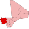
 Sony Location in Mali | |
| Coordinates: ML 14°42′54″N 12°3′14″W / 14.71500°N 12.05389°WCoordinates: ML 14°42′54″N 12°3′14″W / 14.71500°N 12.05389°W | |
| Country |
|
| Region | Kayes Region |
| Cercle | Kayes Cercle |
| Population (2009 census)[1] | |
| • Total | 11,125 |
| Time zone | GMT (UTC+0) |
Sony is a commune in the Cercle of Kayes in the Kayes Region of south-western Mali. The main town (chef-lieu) is Lany Tounka. The commune lies to the south of the Senegal River. In 2009 the commune had a population of 11,125.
References
- ↑ Resultats Provisoires RGPH 2009 (Région de Kayes) (PDF) (in French), République de Mali: Institut National de la Statistique.
External links
- Plan de Securité Alimentaire Commune Rurale de Sony 2007–2011 (PDF) (in French), Commissariat à la Sécurité Alimentaire, République du Mali, USAID-Mali, 2006.
This article is issued from Wikipedia - version of the 10/22/2016. The text is available under the Creative Commons Attribution/Share Alike but additional terms may apply for the media files.