Dimaro
| Dimaro | ||
|---|---|---|
| Comune | ||
| Comune di Dimaro | ||
|
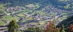
View of Dimaro and Carciato from Bolentina. | ||
| ||
 Dimaro Location of Dimaro in Italy | ||
| Coordinates: 46°20′N 10°52′E / 46.333°N 10.867°ECoordinates: 46°20′N 10°52′E / 46.333°N 10.867°E | ||
| Country | Italy | |
| Region | Trentino-Alto Adige/Südtirol | |
| Province / Metropolitan city | Trentino (TN) | |
| Frazioni | Folgarida, Carciato | |
| Area | ||
| • Total | 28.3 km2 (10.9 sq mi) | |
| Elevation | 766 m (2,513 ft) | |
| Population (Dec. 2004) | ||
| • Total | 1,193 | |
| • Density | 42/km2 (110/sq mi) | |
| Demonym(s) | Dimari | |
| Time zone | CET (UTC+1) | |
| • Summer (DST) | CEST (UTC+2) | |
| Postal code | 38025 | |
| Dialing code | 0463 | |
| Website | Official website | |
Dimaro (in local dialect: Dimàr, German: Diemmer) is a comune (municipality) in Trentino in the northern Italian region Trentino-Alto Adige/Südtirol, located about 66 kilometres (41 mi) northwest of Trento. As of 31 December 2004, it had a population of 1,193 and an area of 28.3 square kilometres (10.9 sq mi).[1]
The municipality of Dimaro contains the frazioni (subdivisions, mainly villages and hamlets) Folgarida and Carciato.
Dimaro borders the following municipalities: Malè, Commezzadura, Monclassico.
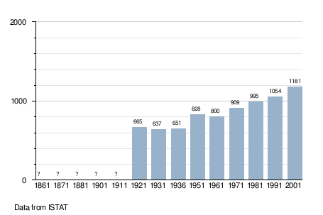
Demographic evolution
References
External links
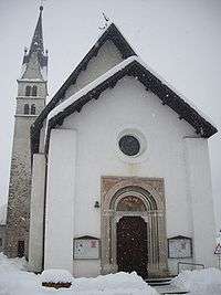
Church
- (Italian) Homepage of the city

This article is issued from Wikipedia - version of the 11/7/2016. The text is available under the Creative Commons Attribution/Share Alike but additional terms may apply for the media files.