Dutton, Cheshire
| Dutton | |
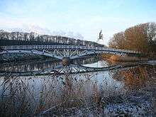 Dutton horse bridge and River Weaver |
|
 Dutton |
|
| Population | 424 |
|---|---|
| District | Cheshire West and Chester |
| Shire county | Cheshire |
| Region | North West |
| Country | England |
| Sovereign state | United Kingdom |
| Postcode district | WA4 |
| Dialling code | 01928 |
| Police | Cheshire |
| Fire | Cheshire |
| Ambulance | North West |
| EU Parliament | North West England |
Coordinates: 53°18′28″N 2°38′12″W / 53.307739°N 2.63674°W
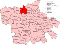
Dutton is a civil parish and village within the unitary authority of Cheshire West and Chester in the ceremonial county of Cheshire, England. It is located approximately 2 miles (3 km) east of Runcorn. Dutton is on the river Weaver and is home to Dutton Hall which was built in 1513. A viaduct of 20 arches, each 63 feet in span, and 60 feet high, takes the Grand Junction railway over Dutton Bottom, across the valley of the Weaver.[1]
It had a population of 424 according to the 2011 census.[2]
Industry
From the data of the 1881 census,it was shown that the dominant occupation of Dutton's population was agriculture with a total of 61 males and 3 females with this occupation. For males, workers in general or unspecified commodities was the second most populous occupation with a total of 16 males. The majority of Women in 1881 were persons without specified occupations, with a total of 40 listed with this occupation.[3] The main occupations for males in Dutton at the present time, according to the 2011 census key statistics data, are Skilled Trade Occupations, with a total of 22.7% of the economically active males with this occupation, and Managers, Directors and Senior Officials with a total of 20% of males having this occupation.[4] The main two occupations for women in Dutton, are, Professional Occupations with a total of 23.8% of females working in this area, and, Managers, Directors and Senior Officials, which has a total of 20% of females in Dutton with this occupation.[5]
History
It was known at Domesday as Duntune; and it belonged to the ancient family of Dutton, who had jurisdiction over the minstrels and pipers of the county. Dutton Hall was built in 1513 by the Duttons, and what remains of the hall represent and exhibit fine features of the architecture of its period.[6]
In 1887, Dutton was described as;
- "Dutton.-- township, Great Budworth par., mid. Cheshire, on river Weaver, 5½ miles NW. of Northwich, 2090 ac. (36 water), pop. 452."[7]

Population
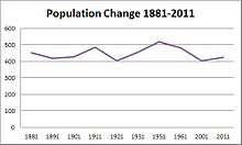
The overall population of Dutton has been fluctuating from 1881 to 2011, with an overall net loss in population. According to the 1881 census data, there were 452 people living in Dutton, whereas the population in 2011 was 424. This shows a loss of 28 people over the 130-year period recorded.[8] The population density of Dutton is 0.4 (Number of persons per hectare) according to the 2011 census data. This is significantly less than the average population density of England which is 5.0 persons per hectare. However due to its rural status, Dutton is expected to have a much lower density than major towns and cities.[9]
Housing and transport
The dominant housing in Dutton is detached housing with a total of 80 out of the 180 households in Dutton being detached. There is also 41 semi-detached houses in the Dutton parish. There is also a large amount of caravans or other mobile or temporary structures in Dutton, with 45 of these in total.[10] There are a total of 315 cars or vans registered in Dutton according to the 2011 census data. The majority of households, 71 out of the 180 households, have one car or van. Whereas 69 households have 2 cars or vans available. There is a total of 9 households which has no car or van available.[11]
See also
References
- ↑ Wilson, John Marius. "Imperial Gazetteer of England and Wales". Fullarton and Co., of London & Edinburgh. Retrieved 23 March 2013.
- ↑ "Dutton: Key Figures for 2011 Census: Key Statistics". Office for National Statistics. Retrieved 4 Feb 2013.
- ↑ Woollard, Matthew. "1881 Occupational Orders". University of essex. Retrieved 22 Mar 2013.
- ↑ "Occupation - Males 2011". Office for National Statistics. Retrieved 11 April 2013.
- ↑ "Females - occupation, 2011". Office for National Statistics. Retrieved 11 April 2013.
- ↑ Wilson, John. "Imperial Gazetteer of England and Wales". A. Fullarton and co. Retrieved 1 April 2013.
- ↑ Bartholomew, John (1887). Gazetteer of the British Isles (1st ed.). Edinburgh: Bartholomew. Retrieved 4 Feb 2013.
- ↑ "Total Population, A Vision of Britain through Time". Vision of Britain. Retrieved 1 April 2013.
- ↑ "Population Density, 2011". Neighbourhood statistics. Retrieved 26 April 2013.
- ↑ "Accommodation Type - households". Neighbourhood statistics. Retrieved 5 April 2013.
- ↑ "Car or van availability". Neighbourhood statistics. Retrieved 5 April 2013.
External links
| Wikimedia Commons has media related to Dutton, Cheshire. |
Cheshire Portal | |
| Unitary authorities | |
| Major settlements | |
| Rivers | |
| Topics | |