Beeston, Cheshire
| Beeston | |
 Beeston Castle gate |
|
 Beeston |
|
| Population | 188 (Civil Parish, 2011) |
|---|---|
| OS grid reference | SJ541585 |
| Civil parish | Beeston |
| Unitary authority | Cheshire West and Chester |
| Ceremonial county | Cheshire |
| Region | North West |
| Country | England |
| Sovereign state | United Kingdom |
| Post town | CHESTER |
| Postcode district | CW6 |
| Dialling code | 01829 |
| Police | Cheshire |
| Fire | Cheshire |
| Ambulance | North West |
| EU Parliament | North West England |
| UK Parliament | Eddisbury |
Coordinates: 53°07′24″N 2°41′10″W / 53.123368°N 2.6861262°W
Beeston is a village and civil parish in the unitary authority of Cheshire West and Chester, which itself is located in the ceremonial county of Cheshire in the north of England. It is located approximately 10 km south-east of Chester, and approximately 3.5 km south-west of Tarporley, close to the Shropshire Union Canal.[1] According to the 2011 census, Beeston had a population of 188.[2]
History
Beeston Castle nearby is a spectacular clifftop ruin in the care of English Heritage. Peckforton Castle is not far away. In the 1870s, the castle at Beeston was described as:
- Beeston Castle here crowns an isolated sandstone rock, 366 feet high; and commands a charming view of the vale of Cheshire, and over the Mersey to Liverpool. The castle was built, as a fortress, in 1228, by Ranulph de Blundeville; became a royal garrison between Henry III. and his barons; was dismantled, in 1645, by order of parliament; and is now an extensive and picturesque ruin.[3]
Population
According to the 1881 Census data, the population of Beeston was 328. Of these, 56 were engaged in agriculture, suggesting a strong farming community in the area. 30 persons were employed in domestic service in the parish at the time as well, possibly indicating the presence of a country estate. There was also a schoolmaster, an innkeeper and a shopkeeper, which suggests that there was a school, an inn and a village shop present in 1881.[4]
The overall trend for in Beeston has been that the population has reduced since the 1881 census, with approximately 188 people living in the village in 2011.[5] This is despite the overall number of households in the parish increasing.[6]
Transport
Beeston is located off the A49, which bypasses the village to the east.
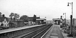
The village was once served by Beeston Castle and Tarporley railway station on the Chester to Crewe main line. The station closed to goods traffic in January 1965, and to passengers 15 months later, in April 1966. The line remains open, and sections of the platforms are still in situ.[7]
See also
References
- ↑ "Beeston Google Maps". Google Maps. Google. Retrieved 21 March 2013.
- ↑ "Beeston (Parish): Key Figures for 2011 Census: Key Statistics". Neighbourhood Statistics. Office for National Statistics. Archived from the original on 29 July 2014. Retrieved 10 February 2016.
- ↑ Wilson, John (1870–72). Imperial Gazetteer of England and Wales. Edinburgh: A. Fullarton and Co. Retrieved 4 February 2013.
- ↑ "1881 Census of England and Wales". A Vision of Britain Through Time. University of Portsmouth. Retrieved 3 April 2013.
- ↑ "Beeston Tn/CP / Population / Total Population". A Vision of Britain Through Time. University of Portsmouth. Retrieved 3 April 2013.
- ↑ "Beeston Tn/CP / Housing / Total Households". A Vision of Britain Through Time. University of Portsmouth. Retrieved 3 April 2013.
- ↑ Wright, Paul. "Beeston Castle & Tarporley". Disused Stations. Retrieved 21 March 2013.
External links
| Wikimedia Commons has media related to Beeston, Cheshire. |
Cheshire Portal | |
| Unitary authorities | |
| Major settlements | |
| Rivers | |
| Topics | |