Edison Park, Chicago
| Edison Park | |
|---|---|
| Community area | |
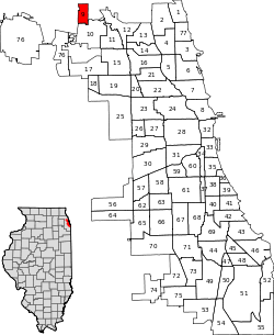
| Community Area 09 - Edison Park | |
|
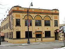
Fieldhouse in Edison Park on the Northwest Highway | |
 Location within the city of Chicago | |
| Coordinates: 42°0.6′N 87°48.6′W / 42.0100°N 87.8100°WCoordinates: 42°0.6′N 87°48.6′W / 42.0100°N 87.8100°W | |
| Country | United States |
| State | Illinois |
| County | Cook |
| City | Chicago |
| Neighborhoods | |
| Area | |
| • Total | 1.17 sq mi (3.03 km2) |
| Population (2010) | |
| • Total | 11,187 |
| • Density | 9,600/sq mi (3,700/km2) |
| Demographics 2010[1] | |
| • White | 88.4% |
| • Black | 1.26% |
| • Hispanic | 7.79% |
| • Asian | 2.40% |
| • Other | 1.15% |
| Time zone | CST (UTC-6) |
| • Summer (DST) | CDT (UTC-5) |
| ZIP Codes | part of 60631 |
| Median household income[2] | $77,678 |
| Source: U.S. Census, Record Information Services | |

Edison Park (formerly Canfield) is one of the 77 community areas of Chicago, in North Side, Chicago, Illinois.
It consists entirely of the Edison Park neighborhood, and is named after Thomas Alva Edison.[3] T. Edison gave his blessing to this community namesake in 1890. According to the 2000 Census, its population is 11,259. Edison Park has one of the highest concentrations of Irish ancestry in Chicago, where they make up over three-fourths of the neighborhood's population.
Located between the Des Plaines River and the Chicago River this area served as a local continental divide, with the Chicago River flowing then into Lake Michigan, which connected to the Atlantic Ocean through the Great Lakes, and the Des Plaines River feeding into the Illinois River and the Mississippi River to reach the Gulf of Mexico. Edison Park served as one of the portage points for early travelers who would carry their canoes across it to the north branch of the Chicago River corridor and is conveniently located next to Portage Park, Chicago, more generally recognized for this type of access.
Edison Park's settlement history dates back to 1834, with the arrival of pioneer Christian Ebinger Sr., 21, and his family: parents John and Katherine Ebinger along with his new bride, Barbara. As they traveled northwest from Chicago on the Indian trail to Milwaukee, Wisconsin (Milwaukee Avenue), their single horse was bitten by a snake and died, leaving them stranded. Consequently, the Ebingers decided to settle between Touhy and Devon. Their settlement location was west of the North Branch of the Chicago River, where they were joined by Christian's older brothers Frederick and John along with their sister Elizabeth (Mrs. John) Plank. The local public elementary school was named after Christian Ebinger.
One tradition in the community since 1972 is the Edison Park Festival, an end-of-summer weekend sponsored by the Edison Park Chamber of Commerce, combining merchant sidewalk sales, entertainment, a parade, Taste of Chicago and arts and crafts. It is an opportunity to introduce visitors to the benefits and beauty of the Edison Park community. The EP Fest is celebrated every year in mid-August.
Edison Park has the lowest violent crime rate of any Chicago neighborhood. Ranked as one of the best neighborhoods in Chicago, Edison Park also boasts a variety of restaurants and bars.
References
- ↑ Paral, Rob. "Chicago Demographics Data". Retrieved 3 June 2012.
- ↑ Paral, Rob. "Chicago Census Data". Retrieved 22 September 2012.
- ↑ Gannett, Henry (1905). The Origin of Certain Place Names in the United States. Govt. Print. Off. p. 114.
External links
- Official City of Chicago Edison Park Community Map
- The Northwest Chicago Historical Society's history of Edison Park
- Edison Park Chamber of Commerce
- History of Edison Park
- Chicago Landmarks
- Chicago Park District
 |
Park Ridge, Illinois | Park Ridge | Niles, Illinois | |
| Park Ridge | |
Niles | ||
| ||||
| | ||||
| Park Ridge | Norwood Park, Chicago | Old Norwood Park, Chicago |