Bridgeport, Chicago
| Bridgeport | |
|---|---|
| Community area | |
| Community Area 60 - Bridgeport | |
|
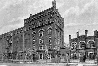
The White Eagle Brewing Company building in Bridgeport, designed by John S. Flizikowski, once stood at the corner of W. 37th Street and Racine. | |
 Location within the city of Chicago | |
| Coordinates: 41°50.4′N 87°39.0′W / 41.8400°N 87.6500°WCoordinates: 41°50.4′N 87°39.0′W / 41.8400°N 87.6500°W | |
| Country | United States |
| State | Illinois |
| County | Cook |
| City | Chicago |
| Neighborhoods |
list
|
| Area | |
| • Total | 2.10 sq mi (5.44 km2) |
| Population (2010) | |
| • Total | 31,925 |
| • Density | 15,000/sq mi (5,900/km2) |
| Demographics 2010[1] | |
| • White | 35.1% |
| • Black | 2.1% |
| • Hispanic | 27.0% |
| • Asian | 34.5% |
| • Other | 1.3% |
| Time zone | CST (UTC-6) |
| • Summer (DST) | CDT (UTC-5) |
| ZIP codes | parts of 60608, 60609 and 60616 |
| Median income | $35,535 |
| Source: U.S. Census, Record Information Services | |
Bridgeport, one of 77 community areas of Chicago, Illinois, is a neighborhood on the city's South Side, bounded on the north by the South Branch of the Chicago River, on the west by Bubbly Creek, on the south by Pershing Road, and on the east by the Union Pacific railroad tracks. Neighboring community areas are the Lower West Side across the river to the north, McKinley Park to the west, Canaryville to the south, and Armour Square to the east. Bridgeport has been the home of five Chicago mayors. Once known for its racial intolerance, Bridgeport today ranks as one of the city's most diverse neighborhoods.[2]
History
Historically, much of the neighborhood was initially an Irish-American enclave. In the 1830s, large numbers of immigrants from Ireland started settling in this working-class neighborhood. Many of the same Irish immigrants who helped build the Erie Canal later came to Chicago to work on the Illinois and Michigan Canal. Because of inadequate funding for the project, the State of Illinois began issuing "Land Scrip" to the workers rather than paying them with money. A large number of those Irish-Americans who received the scrip used it to purchase canal-owned land at the northern end of the canal where it meets the south branch of the Chicago River. The original Bridgeport village, named "Hardscrabble," centered on what is now the section of Throop Street north of 31st Street.[3] The area later became known as Bridgeport because of its proximity to a bridge on the Chicago River, which was too low to allow safe passage for boats, forcing cargo to be unloaded there. Finley Peter Dunne later wrote about this area in popular sketches around the turn of the 20th century. Dunne's protagonist, Mr. Dooley, lived on "Archey Road" (present day Archer Avenue).
Although the Irish are Bridgeport's oldest and arguably most famous ethnic group, Bridgeport has also been home to a large number of other groups. Bridgeport is also home to many Italian-Americans, as is its smaller neighbor to the east, Armour Square.[4][5] Many Lithuanian-Americans settled along Lituanica Avenue, which runs between 31st Street and 38th Place one block west of Halsted Street in what was once called "Lithuanian Downtown" and the center of Lithuanian settlement in Chicago. Today, there are also large numbers of first and second generation Mexican-Americans and Chinese-Americans who, like the Irish immigrants of the 19th century, have settled in the Bridgeport area due to its affordable housing and proximity to their work.
Bridgeport's Polish history is most visibly represented in its two churches in the Polish Cathedral style: St. Mary of Perpetual Help, and St. Barbara. The Art Institute of Chicago has done restoration work on the paintings in the Shrine Altars at St. Mary of Perpetual Help which date back to 1890, with further plans calling for restoration of the stained glass windows and to complete the painting of the interior ceilings and rotunda.
The Chinese influence in Bridgeport has also followed in the tradition of ethnic groups in the neighborhood establishing places of worship, with the Ling Shen Ching Tze (真佛宗美) Buddhist Temple on West 31st Street being established in 1992.[6]
Political history
Bridgeport has been the home or birthplace of five mayors of Chicago, representing all but 10 years between 1933 and 2011, illustrating the neighborhood's influence on Chicago politics for most of the 20th century:[7]
- Edward Joseph Kelly, mayor of Chicago from 1933 to 1947;
- Martin H. Kennelly, mayor of Chicago from 1947 to 1955;
- Richard J. Daley, mayor of Chicago from 1955 until his death in 1976;
- Michael A. Bilandic, initially appointed by City Council to finish Richard J. Daley's term as mayor, the former Bridgeport alderman won the special election in 1977 and served until 1979;
- Richard M. Daley, mayor of Chicago from 1989 until 2011, son of Richard J. Daley.
Kelly, Kennelly, the elder Daley, and Bilandic comprised an unbroken, 46-year period (1933-1979) in which Bridgeport was home to the city's mayor. Richard J. Daley is widely acknowledged as being the architect of the Chicago's 'machine politics' for a large part of the 20th Century.[8] Daley's base was rooted largely in Bridgeport's working-class Irish population with the 11th Ward as his vanguard.[9][10] The 11th Ward Democratic party, which is headquartered in Bridgeport near 36th Street and Halsted, remains a stronghold of the Daley family today, represented by Alderman Patrick Daley Thompson and his uncle, Committeeman John P. Daley.[11] Alderman Thompson represents the third generation of the Daley family to serve in Chicago politics: he is the grandson of Richard J. Daley and the nephew of Richard M. Daley. Thompson was sworn into office in May 2015.
Education
Primary and secondary schools
The Chicago Public School District operates several primary schools in Bridgeport, including Mark Sheridan Academy, Philip D. Armour School, Robert Healy School, Charles N. Holden School, and George B. McClellan School.[12][13] Residents are zoned to Tilden High School in the Canaryville neighborhood just south of Bridgeport.[14]
Parochial elementary schools in Bridgeport operating under supervision of the The Archdiocese of Chicago include Bridgeport Catholic Academy, Santa Lucia School, St. Jerome School, St. Mary School and St Barbara School.
Public libraries
The Richard J. Daley Branch of the Chicago Public Library system is located at 3400 South Halsted Street.[15]
Demographics
Historical population
| Historical population | |||
|---|---|---|---|
| Census | Pop. | %± | |
| 1930 | 53,553 | — | |
| 1940 | 49,109 | −8.3% | |
| 1950 | 46,070 | −6.2% | |
| 1960 | 41,560 | −9.8% | |
| 1970 | 35,150 | −15.4% | |
| 1980 | 30,923 | −12.0% | |
| 1990 | 29,877 | −3.4% | |
| 2000 | 33,694 | 12.8% | |
| 2010 | 31,925 | −5.3% | |
Source:[16]
Culture
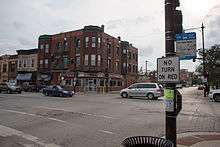
In 2008 the Chicago Sun-Times listed Bridgeport as one of the four most ethnically diverse neighborhoods in Chicago, alongside Albany Park, West Ridge, and Rogers Park. A traditionally working-class neighborhood, with a diverse ethnic heritage, Bridgeport's cultural history has left an indelible mark on Chicago cuisine. While pizza is well represented in Bridgeport, it is the breaded-steak sandwich served by most of the neighborhood's pizzerias, that the neighborhood can claim as an original.[17] Chinese and Mexican fare are also well represented, particularly along 31st Street, Halsted Street, and Archer Avenue. Bridgeport in the early 21st century has also begun to experience an upswing in new restaurants, with a few recent additions serving a wide range of items.[18]
The neighborhood is served by the Bridgeport News, a community newspaper delivered weekly on Wednesdays to homes throughout the neighborhood.
Public transit
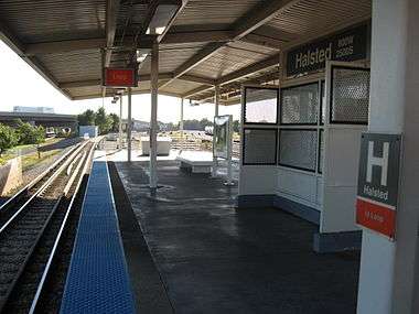
The area is served by the Chicago Transit Authority's Orange Line at the Halsted and Ashland stations, although Ashland is a few blocks outside of the neighborhood.
Notable residents
- ShanZuo and DaHuang Zhou (known professionally as the Zhou Brothers), visual artists and founders/directors of the Zhou B Art Center on 35th Street
- Benn Jordan, composer and recording artist
- Jonathan Sadowski, movie and TV actor
- Martin Felsen, architect at UrbanLab
References
- ↑ Paral, Rob. "Chicago Demographics Data". Archived from the original on 2 June 2013. Retrieved 6 June 2012.
- ↑ "Bridgeport Rising: The consequences of the whiteout of a neighborhood's changing face". newcity.com. 30 June 2010. Retrieved 9 October 2016.
- ↑ "Bridgeport: Lock Zero". uic.edu. Retrieved 9 October 2016.
- ↑ DeGrane, Susan. "A Little Italy". chicagoreader.com. Retrieved 9 October 2016.
- ↑ "Chicago's Bridgeport neighborhood comes out as diverse - Jeff McMahon - Scorched Earth - True/Slant". trueslant.com. Retrieved 9 October 2016.
- ↑ "Google Maps". google.com. Retrieved 9 October 2016.
- ↑ "BRIDGEPORT: CHAPTER V". uic.edu. Retrieved 9 October 2016.
- ↑ Weisberg, Jacob (23 July 2012). "Chicago Style". Retrieved 9 October 2016 – via Slate.
- ↑ "Irish Politics". wikitree.com. Retrieved 9 October 2016.
- ↑ "Despite Suburban Address, Finley An Old Machine Pol". chicagotribune.com. Retrieved 9 October 2016.
- ↑ "11th Ward". 11thward.com. Retrieved 9 October 2016.
- ↑ Black, Lisa. "Army of volunteers gives Bridgeport school a makeover." Chicago Tribune. June 14, 2008.
- ↑ "Home". Charles N. Holden School. Retrieved November 15, 2008.
- ↑ "Geographic Information Systems". Chicago Public Schools. Retrieved November 15, 2008.
- ↑ "Daley Library". Chicago Public Library. Retrieved November 15, 2008.
- ↑ Paral, Rob. "Chicago Community Areas Historical Data". Chicago Community Areas Historical Data. Archived from the original on 18 March 2013. Retrieved 29 August 2012.
- ↑ http://www.chicagojoes.net/sandwiches1.htm
- ↑ http://www.urbanspoon.com/nf/2/104/37148/Chicago/Bridgeport/Organic-Restaurants
External links
| Wikivoyage has a travel guide for Chicago/Bridgeport-Chinatown. |
- City of Chicago Bridgeport Community Map
- Images Of America: Bridgeport (Arcadia Press)
- Bridgeport's History
 |
Lower West Side, Chicago | |
| |
| McKinley Park, Chicago | |
Armour Square, Chicago | ||
| ||||
| | ||||
| New City, Chicago | Fuller Park, Chicago |