Edisto Island, South Carolina
| Edisto Island | |
|---|---|
| Unincorporated area | |
 Edisto Island Location within the state of South Carolina | |
| Coordinates: 32°33′34″N 80°17′42″W / 32.55944°N 80.29500°WCoordinates: 32°33′34″N 80°17′42″W / 32.55944°N 80.29500°W | |
| Country | United States |
| State | South Carolina |
| County | Charleston |
| Area | |
| • Total | 67.8 sq mi (175.5 km2) |
| • Land | 67.6 sq mi (175.1 km2) |
| • Water | 0.2 sq mi (0.4 km2) |
| Elevation | 8 ft (3 m) |
| Time zone | Eastern (EST) (UTC-5) |
| • Summer (DST) | EDT (UTC-4) |
| GNIS feature ID | 1247638[1] |
Edisto Island is one of South Carolina's Sea Islands, the larger part of which lies in Charleston County, with its southern tip in Colleton County. The town of Edisto Beach is in Colleton County, while the Charleston County part of the island is unincorporated.
The island, town, and Edisto River are named after the historic Edistow people, a Native American sub-tribe of the Cusabo Indians, who inhabited the island as well as nearby mainland areas.
History
Indigenous peoples often had fishing camps on the islands, using them seasonally. The historic Edisto people are known to have occupied the island as well as mainland areas and traded with the upcountry Catawba.[2] The sub-tribe became extinct during the colonial period. The Wassamassaw Tribe of Varnertown Indians is a group of descendants of various tribes who intermarried and who have occupied a settlement between Summerville and Moncks Corner in Berkeley County, South Carolina. In 2005 they gained state recognition as an Indian group, one of six tribes to do so.[2][3]
The first tracts of land, called plantations, were granted on Edisto Island before 1700. Landowners first harvested timber and deerskins, planted indigo and some rice, and kept herds of free-ranging cattle to produce hides for the European market and salt beef for Caribbean plantations. Cotton gradually became the principal crop, and after the American Revolution, Edisto Island planters became wealthy and famous from their production of long-staple Sea Island cotton. The labor done by hundreds of enslaved Africans who developed the creole Gullah language and culture on the islands and in the Lowcountry, distinctive for its African traditions.
Since the twentieth century, the island has been redeveloped for use as a tourist destination and resorts, although some private plantations remain.
The Alexander Bache U.S. Coast Survey Line, Bailey's Store, Bleak Hall Plantation Outbuildings, Brick House Ruins, Brookland Plantation, Cassina Point, Crawford's Plantation House, Edisto Island Baptist Church, Edisto Island Presbyterian Church, Fig Island, Frogmore, Paul Grimball House Ruins, Hutchinson House, Middleton's Plantation, Oak Island, Old House Plantation, Peter's Point Plantation, Presbyterian Manse, Prospect Hill, William Seabrook House, Seaside School, Seaside Plantation House, Spanish Mount Point, Sunnyside, Hephzibah Jenkins Townsend's Tabby Oven Ruins, Trinity Episcopal Church, Wescott Road, and Windsor Plantation are listed in the National Register of Historic Places.[4]
Geography
Edisto Island is located 42 miles (68 km) (about one hour by car) southwest of Charleston. Edisto Island is home to Edisto Beach and Wyndham Oceanridge resort.
The only grocery store near the beach is a BI-LO out on Jungle Road. There are three gas stations and about a dozen independently owned restaurants, most of which specialize in local seafood.
Demographics
As of the census of 2000, there were 2,301 people, 1,030 households, and 685 families residing in the CDP. The population density was about 34 people per square mile. There were 1,193 housing units at an average density of 34ppl/sq mi (84.4/km²). The racial makeup of the CDP was 59.6% White, 39.1% African American, 0.20% Native American, 0.0% Asian, 0.6% from other races, and 0.5% from two or more races. Hispanic or Latino of any race were 1.4% of the population.
There were 1,030 households out of which 31.5% had children under the age of 18 living with them, 41.4% were married couples living together, 21.0% had a female householder with no husband present, and 33.4% were non-families. 28.7% of all households were made up of individuals and 10.8% had someone living alone who was 65 years of age or older. The average household size was 2.55 and the average family size was 3.16.
In the CDP the population was spread out with 27.0% under the age of 18, 9.4% from 18 to 24, 27.8% from 25 to 44, 22.3% from 45 to 64, and 13.4% who were 65 years of age or older. The median age was 36 years. For every 100 females there were 91.8 males. For every 100 females age 18 and over, there were 82.8 males.
The median income for a household in the CDP was $25,962, and the median income for a family was $31,000. Males had a median income of $24,609 versus $19,131 for females. The per capita income for the CDP was $17,500. About 18.2% of families and 20.8% of the population were below the poverty line, including 22.3% of those under age 18 and 34.5% of those age 65 or over.
Notable residents
- James Jamerson, bass player and member of the Funk Brothers, who played Motown hits in the 1960s, was born here.
- Micah Jenkins, Confederate general in the American Civil War, mortally wounded by friendly fire at the Battle of the Wilderness
- Burnet Maybank III, owns the largest private plantation on the island
- Vic Ketchman, professional sports writer who has covered teams such as the Jacksonville Jaguars, Pittsburgh Steelers, and Green Bay Packers.
- Carolina Lafayette Seabrook - born in 1825. The daughter of very well-off cotton planter William Seabrook. Given her name by the Marquis De Lafayette who was visiting the plantation on his tour of the United States in 1824 - 1825.
- James Giles - Slave of and probable half brother of his owner Townsend Mikell. The two grew up together. Giles accompanied Mikell when he joined company I of the 3rd South Carolina Cavalry and served with him through the Confederate War. After the war he became a very successful merchant in Charleston. He received a pension from the state of South Carolina as a Confederate veteran in the 1920s.
References
- ↑ "US Board on Geographic Names". United States Geological Survey. June 30, 2015. Retrieved 2008-01-31.
- 1 2 Bo Petersen, "Researchers explore local tribe's ties to legendary temple", The Post and Courier, 17 April 2005, accessed 14 December 2011
- ↑ Bo Petersen, "Local tribe reclaims its roots, heritage", 17 April 2005, accessed 14 December 2011
- ↑ National Park Service (2010-07-09). "National Register Information System". National Register of Historic Places. National Park Service.
External links
The Lowcountry of South Carolina | ||
|---|---|---|
| Counties | 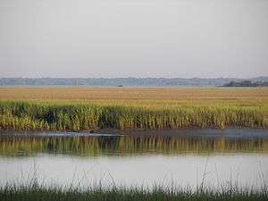 | |
| Major communities | ||
| Sea Islands | ||
| History & culture | ||
| Military installations | ||
| Natural areas | ||
| Other articles | ||
Municipalities and communities of Charleston County, South Carolina, United States | ||
|---|---|---|
| Cities | 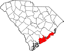 | |
| Towns | ||
| CDP | ||
| Unincorporated communities | ||
| Footnotes | ‡This populated place also has portions in an adjacent county or counties | |