Alexander Bache U.S. Coast Survey Line
|
Alexander Bache U.S. Coast Survey Line | |
|
Alexander Bache Survey Line Marker, January 2013 | |
  | |
| Location | 8377 State Cabin Rd., Edisto Island, South Carolina |
|---|---|
| Coordinates | 32°30′20″N 80°18′37″W / 32.50556°N 80.31028°WCoordinates: 32°30′20″N 80°18′37″W / 32.50556°N 80.31028°W |
| Area | less than one acre |
| Built | 1850 |
| NRHP Reference # | 07001082[1] |
| Added to NRHP | October 5, 2007 |
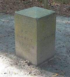
Alexander Bache U.S. Coast Survey Line is a historic geodetic survey line located at Edisto Island, Charleston County, South Carolina. This base line was surveyed by Alexander Dallas Bache and his assistants during January 1850. They buried granite blocks at each endpoint and then placed a granite monument on top of each block.[2][3]
It was listed on the National Register of Historic Places in 2007.[1]
References
- 1 2 National Park Service (2010-07-09). "National Register Information System". National Register of Historic Places. National Park Service.
- ↑ Lindsay Crawford and Al Hester (February 2007). "Alexander Bache U.S. Coast Survey Line" (pdf). National Register of Historic Places - Nomination and Inventory. Retrieved 2014-08-01.
- ↑ "Alexander Bache U.S. Coast Survey Line, Charleston County (8377 State Cabin Rd., Edisto Island)". National Register Properties in South Carolina. South Carolina Department of Archives and History. Retrieved 2014-08-01.
| Topics |   | |
|---|---|---|
| Lists by county |
| |
| Lists by city | ||
| Other lists | ||
This article is issued from Wikipedia - version of the 11/30/2016. The text is available under the Creative Commons Attribution/Share Alike but additional terms may apply for the media files.