Garden River First Nation
| Garden River 14 Gitigaan-ziibi | |
|---|---|
| Indian reserve | |
| Garden River Indian Reserve No. 14 | |
|
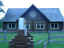
Shke-Sahkehjewaosa Community Centre | |
 Garden River 14 | |
| Coordinates: 46°33′N 84°06′W / 46.550°N 84.100°WCoordinates: 46°33′N 84°06′W / 46.550°N 84.100°W | |
| Country |
|
| Province |
|
| District | Algoma |
| First Nation | Garden River |
| Area[1] | |
| • Land | 215.20 km2 (83.09 sq mi) |
| Population (2011)[1] | |
| • Total | 1,107 |
| • Density | 5.1/km2 (13/sq mi) |
| Time zone | EST (UTC-5) |
| • Summer (DST) | EDT (UTC-4) |
| Website |
www |
Garden River First Nation, also known as Ketegaunseebee (Gitigaan-ziibi Anishinaabe in the Ojibwe language), is an Ojibwa band located at Garden River 14 near Sault Ste. Marie, Ontario, Canada.
The Garden River reserve consists of two non-contiguous areas, totaling 20,703.5 hectares (51,159 acres).[2] The larger, main area is located along the St. Marys River and Highway 17. The Garden River runs through the reserve as a tributary of the St. Mary's River. It is bordered by the Unorganized North Algoma District, Macdonald, Meredith and Aberdeen Additional, the city of Sault Ste. Marie, the Rankin Location Indian reserve, and Sugar Island Township, Michigan, USA.
Garden River First Nation is governed by a band council consisting of a chief and 12 councilors. Council elections are held biannually.[3] The current chief is Paul Syrette.
History
Garden River First Nation was created as a legal entity when Lord Elgin, Governor General of the Province of Canada, approved in law the Robinson Huron Treaty on November 29, 1850. The treaty had been negotiated between the British colony's representative William B. Robinson and numerous Ojibwa chiefs from the Lake Huron watershed earlier that year, and had been signed by these representatives on Sept. 9, 1850. The treaty extinguished Ojibwa title to the land in exchange for 17 reserve lands and annual annuities. Each reserve had to register its band members because an increase to annuity amounts would be determined on a per-person basis.[4]
Garden River First Nation was represented in the treaty by Shingwaukonse, who was generally recognized as an Ojibwe grand chief by other bands in both the Lake Huron and Lake Superior watersheds. Shingwaukonse and his band had been living at their traditional garden lands at the mouth of the Garden River since 1841, after leaving a settlement near Sault Ste. Marie. The treaty formally recognized the band's reserve lands in this vicinity as reservation 14. Upon his death in 1854, Shingwaukonse was succeeded as chief by his son Augustine Shingwauk.[5] The last hereditary chief was Shingwaukonse's second son Buhgwujjenene, who succeeded his brother Augustine.[6]
In the treaty's schedule of reservations, the fourteenth reservation is "a tract of land extending from Maskinongé Bay, inclusive, to Partridge Point, above Garden River on the front, and inland ten miles, throughout the whole distance; and also Squirrel Island."[4] For many years subsequent to signing the treaty, Garden River First Nation disputed the survey of their reserve conducted by the Province of Canada. In April 2003, the government of Canada returned 3,492 hectares of land to the reserve from the adjacent geographic townships of Anderson and Chesley. This resolution was negotiated between the band, the government of Canada, and the province of Ontario in accord with the Indian Lands Agreement of 1986. Ontario also released all mineral rights and revenues on the returned land to Canada to administer for the use of the band.[7]
In a letter written in October 1855, Johann Georg Kohl cites visiting Rivière au Désert ("Garden River" (literally "Desert River") in French), located a few miles for the mouth of the St. Marys River. He recounted a Menaboju story of an encounter with the "Beaver King", in the recounting of "The Legend of Beaverhead Rock and the Origin of the St. Mary's River".[8] Kohl also expressed praise of a beautiful birch bark biting art work he had seen while at Rivière au Désert[8]
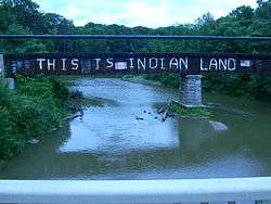
Highway 17 dispute

Highway 17, the primary route of the Trans-Canada Highway, was realigned when a four-lane bypass opened north of the existing roadway on October 31, 2007. The reserve objected to the renaming of the old road as Highway 638, and erected its own signs identifying the road, unofficially, as Highway 17B. The municipal councils of Sault Ste. Marie and Macdonald, Meredith and Aberdeen Additional, which border Garden River on either side and are also located on the route of the disputed roadway, both passed municipal resolutions in 2007 supporting Garden River's position. The provincial government of Ontario eventually acceded to the Garden River band's demand, officially designating the route as Highway 17B in early 2009.
In February 2010, Garden River's band council publicly warned that they would consider imposing tolls on the routes of both Highway 17 and Highway 17B through their territory if the provincial government did not assist the council with a funding shortfall of approximately $1 million. They threatened to impose the toll to protest the HST and native people having to pay the tax, not because they wanted a million dollars.[9]
Population
Garden River First Nation has a population of 2,134 members registered under the Indian Act, according to the latest statistics (June, 2006).[10] 1,004 members are resident on the band's reserve, while 1,130 members live off the reserve, predominantly but not exclusively in Sault Ste. Marie. According to Statistics Canada, the 2001 census showed the following: more than 45 per cent of the on-reserve population were under 25 years old; more than 93 per cent spoke only English at home; and more than 56 per cent identified as Catholic and 28 per cent as Protestant.[11]
Notable Garden River First Nation members
- Jordan Nolan - NHL player, with the Los Angeles Kings
- Ted Nolan -former NHL player and coach
- Shingwaukonse
- David B. Williams, painter and printmaker
References
- 1 2 "Garden River 14 census profile". 2011 Census of Population. Statistics Canada. Retrieved 27 May 2015.
- ↑ Band Details
- ↑ Garden River First Nation - Government
- 1 2 Copy of the Robinson Treaty Made in the Year 1850 with the Ojibewa Indians of Lake Huron Conveying Certain Lands to the Crown - Indian and Northern Affairs Canada
- ↑ shingwauktrust1
- ↑ shingwauktrust1
- ↑ Garden River First Nation Celebrates Addition To Its Reserve Lands - Indian and Northern Affairs Canada
- 1 2 Kohl, Johann (2008) [1860]. Kitchi-Gami: Life Among the Lake Superior Ojibway. ISBN 0873516761.
- ↑ "Province mum on legality of toll on Hwy. 17E", Sault Star, February 5, 2010.
- ↑ General Information
- ↑ 2001 Community Profiles
External links
| Wikimedia Commons has media related to Garden River First Nation. |
 |
Unorganized North Algoma | | ||
| Rankin Location 15D Sault Ste. Marie |
|
Unorganized North Algoma | ||
| ||||
| | ||||
| St. Marys River |
Macdonald, Meredith and Aberdeen Additional |
| Cities |  | |
|---|---|---|
| Towns | ||
| Townships | ||
| Villages | ||
| First Nations | ||
| Indian reserves | ||
| Local services boards | ||
| Unorganized areas | ||
| ||