List of extreme points of Bulgaria

The extreme points of Bulgaria include the coordinates that are further north, south, east or west than any other location in Bulgaria; and the highest and the lowest elevations in the country. Also included in this list is the southernmost Bulgaria station in Antarctica. With the exception of Cape Shabla, the easternmost location of Bulgaria, all other extreme points are uninhabited.
The latitude and longitude are expressed in decimal degree notation, in which a positive latitude value refers to the northern hemisphere, and a negative value refers to the southern hemisphere. Similarly, a positive longitude value refers to the eastern hemisphere, and a negative value refers to the western hemisphere. The coordinates used in this article are sourced from Google Earth, which makes use of the World Geodetic System (WGS) 84, a geodetic reference system.
Latitude and longitude

Bulgaria's northernmost point is where the Timok River flows into the Danube. The northern tip of Bulgaria is located in the Vidin Province, and neighbours the Mehedinţi County of Romania. The closest Bulgarian village to that area is Vrav.[1] Bulgaria's most southern point is in the Kardzhali Province's Mount Veykata. At 1,463 metres (4,800 ft), Veykata is the highest Bulgarian peak of the Gyumyurdzhinski Snezhnik ridge in the Eastern Rhodope Mountains,[2] and borders the East Macedonia and Thrace periphery of Greece.[3] Bulgaria's westernmost point is in Mount Shulep Kamak of the Chudintsi Mountain, standing at 1,337 m (4,386 ft).[4] This is the point where the Kyustendil Province borders both the Pčinja District of Central Serbia and the Kriva Palanka municipality of Northeastern Macedonia.[5] Cape Shabla is Bulgaria's easternmost point;[6] it lies in the Dobrich Province, on the country's Black Sea outlet.[7] Also included in this table is St. Kliment Ohridski Base, Bulgaria's station in Antarctica.[8]
| Heading | Location | Province | Bordering entity | Coordinates[nb 1] | Ref |
|---|---|---|---|---|---|
| North | The Timok's mouth into the Danube | Vidin | Mehedinţi County, Romania | 44°12′52″N 22°40′29″E / 44.214555°N 22.67459°E | [1] |
| South | Mount Veykata | Kardzhali | East Macedonia and Thrace, Greece | 41°14′10″N 25°17′17″E / 41.236022°N 25.288167°E | [3] |
| South (Antarctica) | St. Kliment Ohridski Base | Antarctica | N/A | 62°38′29″S 60°21′53″W / 62.641389°S 60.364722°W | [8] |
| West | Mount Shulep Kamak | Kyustendil | Pčinja District, Central Serbia, Serbia and Kriva Palanka, Northeastern Macedonia, Republic of Macedonia | 42°18′46″N 22°21′36″E / 42.312700°N 22.360067°E | [5] |
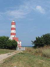
| East | Cape Shabla | Dobrich | Black Sea | 43°32′22″N 28°36′25″E / 43.539550°N 28.607050°E | [7] |
Extreme elevation
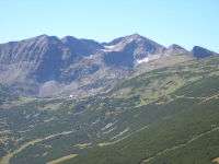
The highest point in Bulgaria is Mount Musala, which, standing at 2,925.4 m (9,598 ft), is located in the Rila National Park. Musala is part of the Rila mountain range in the Sofia Province. In addition to being Bulgaria's highest point, Musala is also taller than any other peak in the Balkans.[9] Other peaks of comparable height in the vicinity of Musala include Little Musala, standing at 2,902 m (9,521 ft), and Irechek, which is 2,852 m (9,357 ft).[10] Bulgaria's lowest point is located on the coast, with its outlet on the Black Sea.[11] The region stays steady at sea level, and stretches 354 km (220 mi), from the Romanian Black Sea Riviera to Turkey's Marmara Region.[11]
| Extremity | Name | Elevation | Location | Province | Coordinates | Ref |
|---|---|---|---|---|---|---|
| Highest | Mount Musala | 2,925.4 m (9,598 ft) | Rila Mountain, Sofia Province | Sofia | 42°06′17″N 23°21′04″E / 42.1047°N 23.3512°E | [10] |
| Lowest | Black Sea | 0 m (0.0 ft) | Bulgarian Black Sea Coast | Dobrich, Varna, and Burgas | 43°30′N 34°30′E / 43.5°N 34.5°E | [11] |
See also
Notes
- ↑ Coordinates obtained from Google Earth. Google Earth makes use of the WGS84 geodetic reference system.
References
- 1 2 Google (11 October 2008). "Timok Mouth" (Map). Google Maps. Google. Retrieved 11 October 2008.
- ↑ "Гюмюрджински снежник". Българска енциклопедия А-Я (in Bulgarian). БАН, Труд, Сирма. 2002. ISBN 954-8104-08-3. OCLC 163361648.
- 1 2 Google (11 October 2008). "Mount Veykata" (Map). Google Maps. Google. Retrieved 11 October 2008.
- ↑ Новаков, Красимир (2000–2008). "Най-крайните географски точки на България" (in Bulgarian). Водач за българските планини.
- 1 2 Google (11 October 2008). "Mount Shulep Kamak" (Map). Google Maps. Google. Retrieved 11 October 2008.
- ↑ "Шабла". Българска енциклопедия А-Я (in Bulgarian). БАН, Труд, Сирма. 2002. ISBN 954-8104-08-3. OCLC 163361648.
- 1 2 Google (11 October 2008). "Cape Shabla" (Map). Google Maps. Google. Retrieved 11 October 2008.
- 1 2 Google (22 October 2008). "St. Kliment Ohridski Base" (Map). Google Maps. Google. Retrieved 22 October 2008.
- ↑ Миланов, Захари (1976). Стоте национални туристически обекта (in Bulgarian). Медицина и физкултура. OCLC 6083589.
- 1 2 "Musala Peak". Encyclopædia Britannica. 2010. Retrieved 11 October 2008.
- 1 2 3 "Bulgaria: Geography". CIA – The World Factbook. Retrieved 18 October 2008.
| History |  | |
|---|---|---|
| Geography | ||
| Wildlife | ||
| Politics and economy | ||
| Demographics and culture | ||
| People | ||
| Miscellaneous | ||
| ||