Forge Road Historic District
|
Forge Road Historic District | |
 | |
  | |
| Location | Warwick, Rhode Island |
|---|---|
| Coordinates | 41°38′18″N 71°27′4″W / 41.63833°N 71.45111°WCoordinates: 41°38′18″N 71°27′4″W / 41.63833°N 71.45111°W |
| Area | 193 acres (78 ha) |
| Architect | Unknown |
| Architectural style | No Style Listed |
| MPS | Warwick MRA |
| NRHP Reference # | 84001861 [1] |
| Added to NRHP | February 23, 1984 |
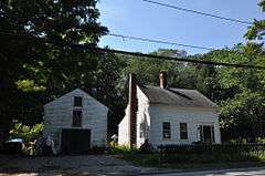
The Forge Road Historic District is a historic district on Forge Road from Ives Road to the Potowomut River in Warwick, Rhode Island. Most of the district's nearly 200 acres (81 ha) are taken up by the Forge Farm, which lies south of Forge Road, is one of the oldest farms in Rhode Island (dating to the mid-17th century), and was the birthplace of American Revolutionary War general Nathanael Greene. A memorial to Greene stands near the bridge crossing the Potowomut River. Opposite the farm on Forge Road stand four houses, all of which date to the late 18th to mid-19th century.[2]
The district was added to the National Register of Historic Places in 1984.[1]
See also
| Wikimedia Commons has media related to Forge Road Historic District. |
References
- 1 2 National Park Service (2007-01-23). "National Register Information System". National Register of Historic Places. National Park Service.
- ↑ "Historic Resources of Warwick (PDF pages 33-38)" (PDF). Rhode Island Preservation. Retrieved 2014-09-03.
| Topics | |
|---|---|
| Lists by states |
|
| Lists by insular areas | |
| Lists by associated states | |
| Other areas | |
| |
This article is issued from Wikipedia - version of the 11/26/2016. The text is available under the Creative Commons Attribution/Share Alike but additional terms may apply for the media files.