Fort Fremont Battery
|
Fort Fremont Battery | |
 | |
  | |
| Nearest city | Frogmore, South Carolina |
|---|---|
| Coordinates | 32°18′20″N 80°38′36″W / 32.30556°N 80.64333°WCoordinates: 32°18′20″N 80°38′36″W / 32.30556°N 80.64333°W |
| Area | 2.8 acres (1.1 ha) |
| Built | 1899 |
| Architectural style | Other, Coastal Fortification |
| MPS | Historic Resources of St. Helena Island c. 1740-c. 1935 MPS |
| NRHP Reference # | 88001821[1] |
| Added to NRHP | May 5, 2010 |
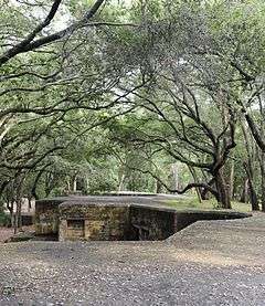
Fort Fremont Battery, located in Beaufort County, South Carolina, is historically significant as an example of late nineteenth and early twentieth century military architecture and as one of two surviving coastal fortifications in the United States intact from the Spanish–American War era.[2][3] The fort was named after John C. Fremont, the first presidential candidate of the Republican Party in 1856. Later, Fremont was a Civil War general. This very accessible landmark was decommissioned and sold at public auction by the War Department in 1930. Fort Fremont Battery was listed in the National Register of Historic Places on May 5, 2010.[1]
References
- 1 2 National Park Service (2010-07-09). "National Register Information System". National Register of Historic Places. National Park Service.
- ↑ Power, J. Tracy; Sherry Piland (February 16, 1988). "Fort Fremont Battery" (pdf). National Register of Historic Places - Nomination and Inventory. Retrieved 7 December 2012.
- ↑ "Fort Fremont Battery, Beaufort County (off Lands End Rd., St. Helena Island)". National Register Properties in South Carolina. South Carolina Department of Archives and History. Retrieved 7 December 2012.
External links
U.S. Geological Survey Geographic Names Information System: Fort Fremont Battery
| Topics |   | |
|---|---|---|
| Lists by county |
| |
| Lists by city | ||
| Other lists | ||
This article is issued from Wikipedia - version of the 11/29/2016. The text is available under the Creative Commons Attribution/Share Alike but additional terms may apply for the media files.