Geography of Qatar
 | |
| Continent | Asia |
|---|---|
| Coordinates | 25°18′N 51°09′E / 25.30°N 51.15°E |
| Area | Ranked 164th |
| • Total | 11,571 km2 (4,468 sq mi) |
| • Land | 100% |
| • Water | 0% |
| Coastline | 563 km (350 mi) |
| Borders | Saudi Arabia: 60 km (37 mi) |
| Highest point |
Qurayn Abu al Bawl, 103 m (338 ft) |
| Lowest point |
Persian Gulf, 0 m (0 ft) |
| Climate | arid; mild, pleasant winters; very hot, humid summers |
| Terrain | mostly flat and barren desert covered with loose sand and gravel |
| Natural Resources | petroleum, natural gas, fish |
| Natural Hazards | haze, dust storms, sandstorms common |
| Environmental Issues | limited natural freshwater resources are increasing dependence on large-scale desalination facilities |
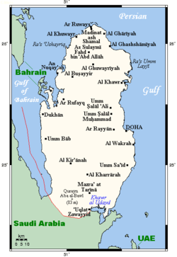
Qatar is a peninsula in the east of Arabia, bordering the Persian Gulf and Saudi Arabia, in a strategic location near major petroleum deposits. Qatar occupies 11,437 km2 (4,416 sq mi) on a peninsula that extends approximately 160 km (99 mi) north into the Persian Gulf from the Arabian Peninsula.
Varying in width between 55 and 90 km (34 and 56 mi), the land is mainly flat (the highest point is 103 m (338 ft)) and rocky. Notable features include coastal salt pans, elevated limestone formations (the Dukhan anticline) along the west coast under which lies the Dukhan oil field, and massive sand dunes surrounding Khawr al Udayd, an inlet of the Persian Gulf in the southeast known to local English speakers as the Inland Sea.
General topography
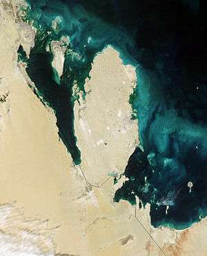
The peninsula of Qatar is low-lying. Its shape the surface expression of the Qatar Arch, one of the largest structural characteristics of the Arabian Plate.[1] It is enveloped by loose sand and pebbles broken off the outcropping limestone. Smooth plains are found in the east, where the surface is covered by fine-grained dust. The south and south-west portion of the peninsula mainly comprises sand dunes and salt flats.[2]
The coastline is emergent and gently slopes toward the sea. Many flat, low-lying offshore islands are located near the coast and are accompanied by coral reefs. As a result of salt water coming into contact with the low-lying land, many salt pans have formed near the coast.[2]
Climate
The long summer (May through September) is characterized by intense heat and alternating dryness and humidity, with temperatures reaching 50 °C (122 °F). Temperatures are moderate from November to April, ranging from as high as 39 °C (102 °F) in April to as low as 7 °C (45 °F) in January.[3] Rainfall is negligible, averaging 100 mm (3.9 in) per year, confined to the winter months, and falling in brief, sometimes heavy storms that often flood the small ravines and the usually dry wadis.[4]
Sudden, violent dust storms occasionally descend on the peninsula, blotting out the sun, causing wind damage, and temporarily disrupting transport and other services.[4]
The scarcity of rainfall and the limited underground water, most of which has such a high mineral content that it is unsuitable for drinking or irrigation, restricted the population and the extent of agricultural and industrial development the country could support until desalination projects began. Although water continues to be provided from underground sources, most is obtained by desalination of seawater.[4]
Vegetation zones
Although most of the country consists of sand deserts, a small part of the country houses different vegetation zones, where trees, reeds and shrubs like tamarind, phragmites, and mace can grow. These regions are mostly to the east, near the coast.
Area and land boundaries

Qatar has one land border. The country borders Saudi Arabia to the south. The boundary with Saudi Arabia was settled in 1965 but never demarcated. Qatar's northwest coast is fewer than 30 km (19 mi) from the main islands of Bahrain, while the small Hawar Islands of Bahrain are only 1.4 km (0.8 mi) off that coast.[4] The peninsula's northernmost point is Ras Rakan.[5]
Maritime claims
contiguous zone:
24 nmi (44.4 km; 27.6 mi)
exclusive economic zone:
as determined by bilateral agreements, or the median line
territorial sea:
12 nmi (22.2 km; 13.8 mi)
Islands
Of the islands belonging to Qatar, Halul is the most important. Lying about 90 km (56 mi) east of Doha, it serves as a storage area and loading terminal for oil from the surrounding offshore fields. Hawar and the adjacent islands immediately off the west coast are the subject of a territorial dispute between Qatar and Bahrain.[4]
Resources and land use
Based on estimates in 2011 estimates, 5.6% of the land is agricultural. Arable land comprises 1.1%, permanent crops 0.2% and permanent pasture 4.6%. 94.4% of the land was used for other uses.[6] In 2003, 129.4 km2 (50.0 sq mi) of land was irrigated.[6]
Geology and mineral deposits
| Era[7][8] | Period | Formation | Member | Mineral deposits and resources |
|---|---|---|---|---|
| Paleozoic | Cambrian | Hormuz Formation | Dolomite, sandstone | Hematite, carbonates, asbestos |
| Permian Carboniferous | Khuff Formation | Petroleum | ||
| Mesozoic | Jurassic | Uwainat Limestone Formation, Arab Formation | Dolomite, limestone, evaporite, shale | Petroleum |
| Cretaceous | Shuaiba Formation | Marlstone, limestone, shale | Petroleum | |
| Cenozoic | Paleocene | Umm Er Radhuma Formation | ||
| Lower Eocene | Rus Formation | Chalk | Celestine, gypsum | |
| Lower Dammam Formation | Dukhan limestone, Midra shale, Rudjm Aid limestone | Palygorskite, pyrite | ||
| Middle Eocene | Upper Dammam Formation | Umm Bab chalk, Simaisma dolomites | Dolomite, limestone | |
| Miocene | Upper and Lower Dam Formation | Clay, limestone, gypsum | Clay, limestone, celestine | |
| Pliocene | Hofuf Formation | Sandy clay, sandstone | Sand, gravel | |
| Pleistocene | Miliolite limestone | Limestone | ||
Most of Qatar's surface lies on Cenozoic strata. These strata have an abundance of mineral resources, most of which have not yet been exploited, such as limestone and clay.[9] The Upper Dammam Formation in the Middle Eocene period is the most predominant surface layer. It is constituted by limestone and dolomite.[10] The northern zone of Qatar, which comprises the most significant source of fresh groundwater in the peninsula, primarily draws its water from the Umm Err Radhuma Formation and Rus Formation dating to the Paleocene and Lower Eocene periods, respectively.[11] The Mesozoic strata are the most important layers as they contain petroleum. The first substantial deposit of crude oil was discovered in 1940 in the Jurassic period Arab Formation.[12]
Political and human geography

The capital, Doha, is located on the central east coast on a sweeping (if shallow) harbor. Other ports include Umm Said, Al Khawr, and Al Wakrah. Only Doha and Umm Said are capable of handling commercial shipping, although a large port and a terminal for loading natural gas are planned at Ras Laffan Industrial City, north of Al Khawr. Coral reefs and shallow coastal waters make navigation difficult in areas where channels have not been dredged.[4]
Doha is the capital of the country and the major administrative, commercial, and population center. In 1993 it was linked to other towns and development sites by a system of about 1,000 km (620 mi) of paved roads. Doha's international airport has an approximately 4,500 m (14,800 ft) main runway, capable of receiving all kinds of aircraft.[4]
Environmental agreements
Qatar is currently party to the following international environmental agreements:[6]
References
- ↑ Jeremy Jameson, Christian Strohmenger. "What's up with Qatar? How eustasy and neotectonics influenced the late Pleistocene and Holocene sea-level history of Qatar". ExxonMobil Research Qatar. Retrieved 17 July 2015.
- 1 2 Abdul Nayeem, Muhammad (1998). Qatar Prehistory and Protohistory from the Most Ancient Times (Ca. 1,000,000 to End of B.C. Era). Hyderabad Publishers. p. 2. ISBN 9788185492049.
- ↑ Casey & Vine (1991), p. 69
- 1 2 3 4 5 6 7 "Geography". Library of Congress Country Studies. Retrieved 17 July 2015.
 This article incorporates public domain material from the Library of Congress Country Studies website http://lcweb2.loc.gov/frd/cs/.
 - ↑ Bird, Eric (2010). Encyclopedia of the World's Coastal Landforms. Springer. p. 1038. ISBN 978-1402086380.
- 1 2 3 "Geography". CIA World Factbook. Retrieved 17 July 2015. This article incorporates public domain material from the CIA World Factbook website https://www.cia.gov/library/publications/the-world-factbook/index.html.
- ↑ Casey & Vine (1991), p. 73
- ↑ Al-Kubaisi, Mohammed Ali M. (1984). Industrial development in Qatar: a geographical assessment (PDF). Durham E-Theses, Durham University. p. 12.
- ↑ Al-Kubaisi, Mohammed Ali M. (1984). Industrial development in Qatar: a geographical assessment (PDF). Durham E-Theses, Durham University. pp. 10–11.
- ↑ Al-Saad, Hamad (2015). "Lithostratigraphy of the Middle Eocene Dammam Formation in Qatar, Arabian Gulf: effects of sea-level fluctuations along a tidal environment". Journal of Asian Earth Sciences. 25: Abstract. doi:10.1016/j.jseaes.2004.07.009. Retrieved 27 July 2015.
- ↑ "Umm er Radhuma-Dammam Aquifer System (Centre)". Inventory of Shared Water Resources in Western Asia. Retrieved 27 July 2015.
- ↑ Al-Kubaisi, Mohammed Ali M. (1984). Industrial development in Qatar: a geographical assessment (PDF). Durham E-Theses, Durham University. p. 11.
External links
- "East of Qatar". Terrestrial Ecoregions. World Wildlife Fund.
Bibliography
- Casey, Paula; Vine, Peter (1991). The heritage of Qatar (print ed.). Immel Publishing. ISBN 978-0907151500.
Qatar articles | |||||||
|---|---|---|---|---|---|---|---|
| Geography |  | ||||||
| Politics | |||||||
| Economy | |||||||
| Society |
| ||||||
| |||||||