Geography of Israel
 | |
| Continent | Asia |
|---|---|
| Region | Levant |
| Coordinates | 31°N 35°E / 31°N 35°ECoordinates: 31°N 35°E / 31°N 35°E |
| Area | Ranked 147th |
| • Total | 20,770[1][2] km2 (8,020 sq mi) |
| • Land | 97.88% |
| • Water | 2.12% |
| Coastline | 187 km (116 mi) |
| Borders | |
| Highest point | Mount Hermon |
| Lowest point | Dead Sea |
| Longest river | Jordan River |
| Largest lake | Sea of Galilee |
| Climate | Mediterranean |
| Natural Resources | Offshore gas fields, Dead Sea minerals (potash, magnesium) |
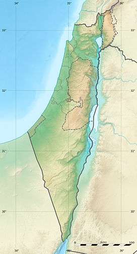
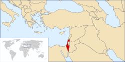
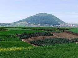
The geography of Israel is very diverse, with desert conditions in the south, and snow-capped mountains in the north. Israel is located at 31°30′N 34°45′E / 31.500°N 34.750°E at the eastern end of the Mediterranean Sea in western Asia.[1] It is bounded to the north by Lebanon, the northeast by Syria, the east by Jordan and the West Bank, and to the southwest by Egypt.[1] To the west of Israel is the Mediterranean Sea, which makes up the majority of Israel's 273 km (170 mi) coastline[3] and the Gaza Strip. Israel has a small coastline on the Red Sea in the south.
Israel's area is approximately 20,770 km2 (8,019 sq mi), which includes 445 km2 (172 sq mi) of inland water.[1][2][3] Israel stretches 424 km (263 mi) from north to south, and its width ranges from 114 km (71 mi) to, at its narrowest point, 15 km (9.3 mi).[3] The Israeli-occupied territories include the West Bank, 5,879 km2 (2,270 sq mi), East Jerusalem, 70 km2 (27 sq mi) and the Golan Heights, 1,150 km2 (444 sq mi).[2] Geographical features in these territories will be noted as such.
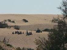
Southern Israel is dominated by the Negev desert, covering some 16,000 square kilometres (6,178 sq mi), more than half of the country's total land area. The north of the Negev contains the Judean Desert, which, at its border with Jordan, contains the Dead Sea which, at −417 m (−1,368 ft) is the lowest point on Earth. The inland area of central Israel is dominated by the Judean Hills of the West Bank, whilst the central and northern coastline consists of the flat and fertile Israeli coastal plain. Inland, the northern region contains the Mount Carmel mountain range, which is followed inland by the fertile Jezreel Valley, and then the hilly Galilee region. The Sea of Galilee is located beyond this, and is bordered to the east by the Golan Heights, which contains the highest point under Israel's control, a peak in the Israeli-occupied Mount Hermon massif, at 2,224 meters (7,297 ft). The highest point in territory internationally recognized as Israeli is Mount Meron at 1,208 meters (3,963 ft).[1]
Location and boundaries
Israel lies to the north of the equator around 31°30' north latitude and 34°45' east longitude.[1] It measures 424 km (263 mi) from north to south and, at its widest point 114 km (71 mi), from east to west.[1] At its narrowest point, however, this is reduced to just 15 km (9 mi). It has a land frontier of 1,017 km (632 mi) and a coastline of 273 km (170 mi).[1] It is ranked 153 on the List of countries and outlying territories by total area.[1]
Prior to the establishment of the British Mandate for Palestine, there was no clear-cut definition of the geographical and territorial limits of the area known as "Palestine." On the eve of World War I it was described by Encyclopedia Britannica as a "nebulous geographical concept."[4] The Sykes-Picot Treaty in 1916 divided the region that later became Palestine into four political units.[5] Under the British Mandate for Palestine, the first geo-political framework was created that distinguished the area from the larger countries that surrounded it. The boundary demarcation at this time did not introduce geographical changes near the frontiers and both sides of the border were controlled by the British administration.[6]
Modern Israel is bounded to the north by Lebanon, the northeast by Syria, the east by Jordan and the West Bank, and to the southwest by Egypt. To the west of Israel is the Mediterranean Sea, which makes up the majority of Israel's 273 km (170 mi) coastline and the Gaza Strip. Israel has a small coastline on the Red Sea in the south. The southernmost settlement in Israel is the city of Eilat whilst the northernmost is the town of Metula. The territorial waters of Israel extend into the sea to a distance of twelve nautical miles measured from the appropriate baseline.[1]
The statistics provided by the Israel Central Bureau of Statistics include the annexed East Jerusalem and Golan Heights, but exclude the West Bank and Gaza Strip. The population of Israel includes Israeli settlers in the West Bank. The route of the Israeli West Bank barrier incorporates some parts of the West Bank.
| Population (thousands) | Area (km2) | ||||||
|---|---|---|---|---|---|---|---|
| Name | Status Description | Israelis (incl. Israeli Jews and Israeli Arabs in Israel proper, and incl. Israeli settlers in the Israeli-occupied territories) | Cumulative Total | Palestinians (incl. non-Israeli Palestinians residing legally in Israel) | Cumulative Total | Area | Cumulative Total |
| Israel (Green Line) | Area sovereign to Israel since 1948 | 6,674[7] | 6,674[7] | 100-120 [8] | 100-120 [8] | 20,582[7] | 20,582[7] |
| East Jerusalem | Occupied and subject to Israeli law since 1967. Formal legislation on 1980 (see Jerusalem Law) | 455[9] | 7,129[7] | 225 (double counted)[10] | 225[7] | 336[11] | 20,918[7] |
| Golan Heights | Occupied since 1967, subject to Israeli law since 1981 (see Golan Heights Law) | 42[12] | 7,172[12] | n.a. | n.a. (Syrians) | 1,154[13] | 22,072[13] |
| Seam Zone (West Bank) | Area between the Green Line and the Israeli West Bank barrier. Occupied in 1967 | 188[14] | 7,359[7] | 35[14] | 260[7] | 200[11] | 22,272[7] |
| Other Israeli settlements and IDF Military Areas (West Bank Area C) | Other Israeli settlements (not in East Jerusalem or the Seam Zone) and areas in the West Bank directly controlled by the IDF. Occupied in 1967 | 57[7] | 7,473[12] | 115[15] | 375[7] | 2,961[16] | 25,233[7] |
| Palestinian civil control (West Bank Areas A+B) | Palestinian National Authority civil controlled area. Subject to "joint" military control with the IDF. Occupied in 1967 | 0 | 7,473[7] | 2,311[17] | 2,686[7] | 2,143[15] | 27,376[7] |
| Gaza Strip | Palestinian governed area. Israel controls airspace, maritime border and its own border with Gaza. Occupied in 1967, unilaterally disengaged in 2005, declared a foreign entity in 2007. | 0 | 7,473[7] | 1,552[18] | 4,238[7] | 360[18] | 27,736[7] |
Physiographic regions
Israel is divided into four physiographic regions: the Mediterranean coastal plain, the Central Hills, the Jordan Rift Valley and the Negev Desert.[1]
Coastal plain
The Israeli Coastal Plain stretches from the Lebanese border in the north to Gaza in the south, interrupted only by Cape Carmel at Haifa Bay.[19] It is about 40 kilometers (25 mi) wide at Gaza and narrows toward the north to about 5 kilometers (3.1 mi) at the Lebanese border.[19] The region is fertile and humid (historically malarial) and is known for its citrus orchards and viticulture.[19] The plain is traversed by several short streams. From north to south these are: the Kishon, the Hadera, the Alexander, the Poleg, and the Yarkon. All of these streams were badly polluted, but in the last ten years much work has been done to clean them up. Today the Kishon, Alexander and Yarkon again flow year round, and also have parks along their banks.[20]
The region is divided into five sub-regions. The Western Galilee stretches from Rosh HaNikra in the far north, down to Israel's third-largest city, Haifa. It is a fertile region containing with a coastline with many small islands off of it.[21] South of Haifa is the Hof HaCarmel region which runs to the town of Zikhron Ya'akov. The Sharon plain is the next stage down the Coastal Plain, running from Zikhron Ya'akov to Tel Aviv's Yarkon River. This area is Israel's most densely populated. South of this, running to Nahal Shikma, is the Central Coastal Plain. The southern region of the Coastal Plain is the Southern Coastal Plain (also known as the Shephelah, Plain of Judea, and Western Negev) and extends south to the Gaza Strip. It is divided into two. The Besor region, a savanna-type area with a relatively large number of communities, in the north, and the Agur-Halutsa region in the south which is very sparsely populated.[21]
Central hills

Inland (east) of the coastal plain lies the central highland region.[19] In the north of this region lie the mountains and hills of Upper Galilee and Lower Galilee, which are generally 500 meters (1,640 ft) to 700 meters (2,297 ft) in height, although they reach a maximum height of 1,208 meters (3,963 ft) at Mount Meron.[19] South of the Galilee, in the West Bank, are the Samarian Hills with numerous small, fertile valleys rarely reaching the height of 800 meters (2,625 ft).[19] South of Jerusalem, also mainly within the West Bank, are the Judean Hills, including Mount Hebron.[19] The central highlands average 610 meters (2,001 ft) in height and reach their highest elevation at Har Meron, at 1,208 meters (3,963 ft), in Galilee near Safed.[19] Several valleys cut across the highlands roughly from east to west; the largest is the Jezreel Valley (also known as the Plain of Esdraelon), which stretches 48 kilometers (30 mi) from Haifa southeast to the valley of the Jordan River, and is 19 kilometers (12 mi) across at its widest point.[19]
Jordan Rift Valley
East of the central highlands lies the Jordan Rift Valley, which is a small part of the 6,500 kilometers (4,039 mi)-long Syrian-East African Rift.[19] In Israel the Rift Valley is dominated by the Jordan River, the Sea of Galilee (an important freshwater source also known as Lake Tiberias and Lake Kinneret), and the Dead Sea.[19] The Jordan, Israel's largest river (322 kilometers (200 mi)), originates in the Dan, Baniyas, and Hasbani rivers near Mount Hermon in the Anti-Lebanon Mountains and flows south through the drained Hula Basin into the freshwater Lake Tiberias. Lake Tiberias is 165 square kilometers (64 sq mi) in size and, depending on the season and rainfall, is at about 213 meters (699 ft) below sea level.[19] With a water capacity estimated at 3 cubic kilometers (0.72 cu mi), it serves as the principal reservoir of the National Water Carrier (also known as the Kinneret-Negev Conduit).[19] The Jordan River continues its course from the southern end of Lake Tiberias (forming the boundary between the West Bank and Jordan) to its terminus in the highly saline Dead Sea.[19] The Dead Sea is 1,020 square kilometers (394 sq mi) in size and, at 420 meters (1,378 ft) below sea level, is the lowest surface point on the earth.[19] South of the Dead Sea, the Rift Valley continues in the Arabah (Hebrew "Arava", Arabic "Wadi 'Arabah"), which has no permanent water flow, for 170 kilometers (106 mi) to the Gulf of Eilat.[19]
Negev Desert
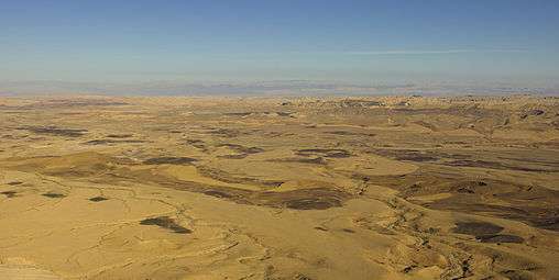
The Negev Desert comprises approximately 12,000 square kilometers (4,633 sq mi), more than half of Israel's total land area.[19] Geographically it is an extension of the Sinai Desert, forming a rough triangle with its base in the north near Beersheba, the Dead Sea, and the southern Judean Mountains, and it has its apex in the southern tip of the country at Eilat.[19] Topographically, it parallels the other regions of the country, with lowlands in the west, hills in the central portion, and the Arava valley as its eastern border.[19]
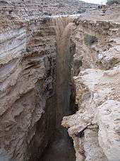
Unique to the Negev region are the craterlike makhteshim cirques; Makhtesh Ramon, Makhtesh Gadol and Makhtesh Katan.[22] The Negev is also sub-divided into five different ecological regions: northern, western and central Negev, the high plateau and the Arabah Valley.[23] The northern Negev receives 300 millimeters (11.8 in) of rain annually and has fairly fertile soils.[23] The western Negev receives 250 millimeters (9.8 in) of rain per year, with light and partially sandy soils.[23] The central Negev has an annual precipitation of 200 millimeters (7.9 in) and is characterized by impervious soil, allowing minimum penetration of water with greater soil erosion and water runoff.[23] This can result in rare flash floods during heavy rains as water runs across the surface of the impervious desert soil.[24] The high plateau area of Ramat HaNegev stands between 370 meters (1,214 ft) and 520 meters (1,706 ft) above sea level with extreme temperatures in summer and winter.[23] The area gets 100 millimeters (3.9 in) of rain each year, with inferior and partially salty soils.[23] The Arabah Valley along the Jordanian border stretches 180 kilometers (112 mi) from Eilat in the south to the tip of the Dead Sea in the north and is very arid with barely 50 millimeters (1.97 in) of rain annually.[23]
Geology
.jpg)
Israel is divided east-west by a mountain range running north to south along the coast. Jerusalem sits on the top of this ridge, east of which lies the Dead Sea graben which is a pull-apart basin on the Dead Sea Transform fault.[25]
The numerous limestone and sandstone layers of the Israeli mountains serve as aquifers through which water flows from the west flank to the east. Several springs have formed along the Dead Sea, each an oasis, most notably the oases at Ein Gedi and Ein Bokek (Neve Zohar) where settlements have developed.[25] Israel also has a number of areas of karst topography. Caves in the region have been used for thousands of years as shelter, storage rooms, barns and as places of public gatherings.[25]
The far northern coastline of the country has some chalk landscapes best seen at Rosh HaNikra, a chalk cliff into which a series of grottoes have been eroded.[26]
Seismic activity
The Jordan Rift Valley is the result of tectonic movements within the Dead Sea Transform (DSF) fault system. The DSF forms the transform boundary between the African Plate to the west and the Arabian Plate to the east. The Golan Heights and all of Jordan are part of the Arabian Plate, while the Galilee, West Bank, Coastal Plain, and Negev along with the Sinai Peninsula are on the African Plate. This tectonic disposition leads to a relatively high seismic activity in the region.
The entire Jordan Valley segment is thought to have ruptured repeatedly, for instance during the last two major earthquakes along this structure in 749 and 1033. The deficit in slip that has built up since the 1033 event is sufficient to cause an earthquake of Mw~7.4.[27]
The most catastrophic earthquakes we know of occurred in 31 BCE, 363, 749, and 1033 CE, that is every ca. 400 years on average.[28] Destructive earthquakes leading to serious loss of life strike about every 80 years.[29] While stringent construction regulations are currently in place and recently built structures are earthquake-safe, as of 2007 the majority of the buildings in Israel were older than these regulations and many public buildings as well as 50,000 residential buildings did not meet the new standards and were "expected to collapse" if exposed to a strong quake.[29] Given the fragile political situation of the Middle East region and the presence there of major holy sites, a quake reaching magnitude 7 on the Richter scale could have dire consequences for world peace.[28]
- Notable earthquakes
The region has experienced many earthquakes, the most destructive we know of are those of 31 BCE, 363, 749, and 1033 CE. Major earthquakes have included:
- 92 BCE – coast hit by tsunamis[30]
- 140 BCE – disastrous earthquake between Tyre and Ptolemais (Acre/Akko)[31][32]
- 31 BCE – epicenter in the Jordan Valley, magnitude at least 7; among the largest in 2000 years.[31] Josephus Flavius writes of 30,000 people killed (War, Chapter 19-4)[33] Damages Emmaus and Caesarea.[32]
- 115 CE – Yavne and Caesarea are hit by a tsunami[30]
- 130 – strong earthquakes affect among other places Caesarea, Lydda and Emmaus.[30] Different sources give varying dates: 129,[34] 131[31][35]
- 306 – tsunami on the Levantine coast.[32] Affects or is felt in Caesarea, Tiberias, Jerusalem.
- 363 – the Galilee earthquake. See also next (365 CE) earthquake. The failed attempt of the Jews to rebuild the Jerusalem Temple during the reign of Emperor Julian is connected by some to the earthquake.
- 419 – earthquake causes destruction in Antipatris[30]
- 502 – Ptolemais allegedly destroyed (Syriac chronicle of Joshua the Stylite[36]), tsunami hits northern coast,[30] Safed, Latrun (Nicopolis) affected[37]
- 551 – affects much of the Middle East, possibly largest event in the Levant (see 551 Beirut earthquake).[31][32] Gush Halav is destroyed. A major tsunami sweeps the coast from Caesarea to Tripoli, Lebanon[30]
- 633 – affects Emmatha in the Yarmouk Valley[38]
- 658 – affects Syria and Palestine.[32] Jerusalem is badly damaged according to the chronicles of Michael the Syrian and Theophanes the Confessor.[39]
- 672 – Ascalon, Gaza and Ramla hit by strong earthquake[30]
- 746–749 – a series of earthquakes, often confused into one (see 749 Galilee earthquake). Tiberias, Baysan (Beit She'an) and Hippos were largely destroyed. A large event was centered in the Jordan Valley and had a magnitude of 7.6.[31][32]
- 808 – An earthquake affects Jerusalem[31]
- 881 – An earthquake on the Levantine coast leads to a tsunami at Acre[32]
- 1016 – Jerusalem, Jaffa and the region around are affected[31][40]
- 1033–34 – an earthquake which is felt for 40 days destroys Ramla, Jericho and Nablus[31]
- 1063 – a large earthquake hits the Levantine littoral. Acre is badly damaged[30]
- 1068 – ground-rupturing event in Wadi Arabah. Ramla was totally destroyed and lay abandoned for four years after losing some 15,000–25,000 inhabitants in the earthquake.[41]
- 1070 – a large earthquake centered in the Beqaa Valley affects Palestine[31][32]
- 1091 – coastal towns affected, city towers collapse[30]
- 1157 - the Hama earthquake affected Christian monasteries and churches in the vicinity of Jerusalem
- 1170 – Caesarea damaged by tremor[30]
- 1202 – an earthquake centered in Syria[37] leaves many towns and castles in northern and central Palestine badly damaged, such as Acre and Nablus. The eastern and western halves of the ruins of the Crusader castle of Jacob's Ford are displaced relatively to each other by 1.6 metres due to the castle's position exactly straddling a faultline
- 1261 – between Akko and Tripoli islands disappear under the sea[30]
- 1752 – coast of Syria and Palestine hit by strong earthquake[30]
- 1759 - the Near East earthquakes of 1759: Nablus and Acre are affected
- 1834 - 1834 Jerusalem earthquake: Jerusalem, Bethlehem, Hebron are affected
- 1837 – the Galilee earthquake of 1837, known as the Safed earthquake. The Roum fault, and its extension south to the Sea of Galilee, were sources of the event[42]
- 1898 – Haifa damaged by earthquake[30]
- 1927 – the Jericho earthquake. The epicenter of the earthquake was in the northern area of the Dead Sea. The cities of Jerusalem, Jericho, Ramle, Tiberias, and Nablus were heavily damaged and at least 500 were estimated to have been killed.[43] The death toll in Jerusalem included more than 130 people and around 450 were injured. About 300 houses collapsed or were severely damaged to the point of not being usable. The earthquake also caused heavy damage to the domes of the Church of the Holy Sepulchre and the al-Aqsa Mosque. The earthquake was especially severe in Nablus where it destroyed around 300 buildings, including the Mosque of Victory and the historic parts of the Great Mosque of Nablus.[44] The death toll in Nablus included more than 150 people and around 250 were injured. In Jericho, a number of houses collapsed, including several relatively new hotels in one of which three female tourists from India were killed.[45] In addition, the Allenby Bridge collapsed and the Jordan river was blocked for about 21 hours following a collapse of marl cliffs from its banks. Ramla and Tiberias were also heavily damaged.
Rivers and lakes
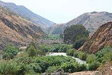
Israel's longest and most famous river is the 320-kilometre (199 mi) long River Jordan, which rises on the southern slopes of Mount Hermon in the Anti-Lebanon mountains.[46] The river flows south through the freshwater Sea of Galilee, and from there forms the boundary with the Kingdom of Jordan for much of its route, eventually emptying into the Dead Sea.[46] The northern tributaries to the Jordan are the Dan, Banias, and Hasbani.[46] Only the Dan is within undisputed Israel; the Hasbani flows from Lebanon and the Banias from territory captured from Syria in the Six-Day War.[46]

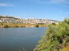
The Sea of Galilee (also called the Kinneret) is Israel's largest and most important freshwater lake, located in the northeast of the country. The pear-shaped lake is 23 kilometres (14 mi) long from north to south, with a maximum width of 13 kilometres (8 mi) in the north, covering 166 square kilometers (64 sq mi). The Kinneret lies 207 meters (679 ft) below sea level and reaches depths of 46 meters (151 ft). In a previous geological epoch the lake was part of a large inland sea which extended from the Hula marshes in northern Israel to 64 kilometers (40 mi) south of the Dead Sea. The bed of the lake forms part of the Jordan Rift Valley.[47]
South of the Kinneret lies the saltwater Dead Sea which forms the border between Israel and Jordan and is 418 meters (1,371 ft) below sea level, making it the lowest water surface on Earth.[48] The Dead Sea is 67 kilometers (42 mi) long with a maximum width of 16 kilometers (10 mi) and also makes up part of the Rift Valley.[48] A peninsula juts out into the lake from the eastern shore, south of which the lake is shallow, less than 6 meters (19.7 ft) deep. To the north is the lake's greatest depth.[48]
There are no navigable, artificial waterways in Israel, although the National Water Carrier, a conduit for drinking water, might be classified as such. The idea of a channel connecting the Mediterranean and Dead Seas or the Red and Dead Seas has been discussed.[49]
Selected elevations
The following are selected elevations of notable locations, from highest to lowest:[50]
| Location | Region | Elevation (feet) | Elevation (meters) |
|---|---|---|---|
| Mount Hermon | Golan Heights (Israeli-occupied) | 7,336 ft. | 2,236 m. |
| Mount Meron | Upper Galilee | 3,964 ft. | 1,208 m. |
| Mount Ramon | Negev | 3,396 ft. | 1,035 m. |
| Mount of Olives | East Jerusalem (Israeli-occupied) | 2,739 ft. | 835 m. |
| Mount Tabor | Lower Galilee | 1,930 ft. | 588 m. |
| Mount Carmel | Haifa | 1,792 ft. | 546 m. |
| Dead Sea | Judean Desert | – 1,368 ft. | – 417 m. |
Climate
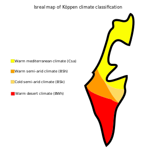
Israel has a Mediterranean climate with long, hot, rainless summers and relatively short, cool, rainy winters (Köppen climate classification Csa).[51] The climate is as such due to Israel's location between the subtropical aridity of the Sahara and the Arabian deserts, and the subtropical humidity of the Levant and Eastern Mediterranean.[51] The climate conditions are highly variable within the state and modified locally by altitude, latitude, and the proximity to the Mediterranean.[51]
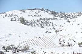
On average, January is the coldest month with average temperatures ranging from 6 to 15 °C (42.8 to 59.0 °F), and July and August are the hottest months at 22 to 33 °C (71.6 to 91.4 °F), on average across the country.[51] Summers are very humid along the Mediterranean coast but dry in the central highlands, the Rift Valley, and the Negev Desert. In Eilat, a desert city, summer daytime-temperatures are often the highest in the state, at times reaching 44 to 46 °C (111.2 to 114.8 °F). More than 70% of the average rainfall in Israel falls between November and March; June through September are usually rainless.[51] Rainfall is unevenly distributed, significantly lower in the south of the country.[51] In the extreme south, rainfall averages near 30 millimeters (1.18 in) annually; in the north, average annual rainfall exceeds 900 millimeters (35.4 in).[51] Rainfall varies from season to season and from year to year, particularly in the Negev Desert. Precipitation is often concentrated in violent storms, causing erosion and flash floods.[51] In winter, precipitation often takes the form of snow at the higher elevations of the central highlands, including Jerusalem.[51] Mount Hermon has seasonal snow which covers all three of its peaks in winter and spring. In rare occasions, snow gets to the northern mountain peaks and only in extremely rare occasions even to the coast. The areas of the country most cultivated are those receiving more than 300 millimeters (11.8 in) of rainfall annually, making approximately one-third of the country cultivable.[51]
Thunderstorms and hail are common throughout the rainy season and waterspouts occasionally hit the Mediterranean coast, capable of causing only minor damage. However, supercell thunderstorms and a true F2 tornado hit the Western Galilee in April 2006, causing significant damage and 75 injuries.[52]
Heat waves are frequent. 2010 was the hottest year in the history of Israel with absolute record high in several places in August. The heat became stronger from August when temperatures were considerably above the average. October and November were also dry, and November was almost rainless when it was supposed to be rainy.
Climate charts of different locations in Israel
| Tel Aviv | ||||||||||||||||||||||||||||||||||||||||||||||||||||||||||||
|---|---|---|---|---|---|---|---|---|---|---|---|---|---|---|---|---|---|---|---|---|---|---|---|---|---|---|---|---|---|---|---|---|---|---|---|---|---|---|---|---|---|---|---|---|---|---|---|---|---|---|---|---|---|---|---|---|---|---|---|---|
| Climate chart (explanation) | ||||||||||||||||||||||||||||||||||||||||||||||||||||||||||||
| ||||||||||||||||||||||||||||||||||||||||||||||||||||||||||||
| ||||||||||||||||||||||||||||||||||||||||||||||||||||||||||||
| Beit Dagan | ||||||||||||||||||||||||||||||||||||||||||||||||||||||||||||
|---|---|---|---|---|---|---|---|---|---|---|---|---|---|---|---|---|---|---|---|---|---|---|---|---|---|---|---|---|---|---|---|---|---|---|---|---|---|---|---|---|---|---|---|---|---|---|---|---|---|---|---|---|---|---|---|---|---|---|---|---|
| Climate chart (explanation) | ||||||||||||||||||||||||||||||||||||||||||||||||||||||||||||
| ||||||||||||||||||||||||||||||||||||||||||||||||||||||||||||
| ||||||||||||||||||||||||||||||||||||||||||||||||||||||||||||
| Jerusalem | ||||||||||||||||||||||||||||||||||||||||||||||||||||||||||||
|---|---|---|---|---|---|---|---|---|---|---|---|---|---|---|---|---|---|---|---|---|---|---|---|---|---|---|---|---|---|---|---|---|---|---|---|---|---|---|---|---|---|---|---|---|---|---|---|---|---|---|---|---|---|---|---|---|---|---|---|---|
| Climate chart (explanation) | ||||||||||||||||||||||||||||||||||||||||||||||||||||||||||||
| ||||||||||||||||||||||||||||||||||||||||||||||||||||||||||||
| ||||||||||||||||||||||||||||||||||||||||||||||||||||||||||||
| Haifa | ||||||||||||||||||||||||||||||||||||||||||||||||||||||||||||
|---|---|---|---|---|---|---|---|---|---|---|---|---|---|---|---|---|---|---|---|---|---|---|---|---|---|---|---|---|---|---|---|---|---|---|---|---|---|---|---|---|---|---|---|---|---|---|---|---|---|---|---|---|---|---|---|---|---|---|---|---|
| Climate chart (explanation) | ||||||||||||||||||||||||||||||||||||||||||||||||||||||||||||
| ||||||||||||||||||||||||||||||||||||||||||||||||||||||||||||
| ||||||||||||||||||||||||||||||||||||||||||||||||||||||||||||
| Safed | ||||||||||||||||||||||||||||||||||||||||||||||||||||||||||||
|---|---|---|---|---|---|---|---|---|---|---|---|---|---|---|---|---|---|---|---|---|---|---|---|---|---|---|---|---|---|---|---|---|---|---|---|---|---|---|---|---|---|---|---|---|---|---|---|---|---|---|---|---|---|---|---|---|---|---|---|---|
| Climate chart (explanation) | ||||||||||||||||||||||||||||||||||||||||||||||||||||||||||||
| ||||||||||||||||||||||||||||||||||||||||||||||||||||||||||||
| ||||||||||||||||||||||||||||||||||||||||||||||||||||||||||||
| Beersheba | ||||||||||||||||||||||||||||||||||||||||||||||||||||||||||||
|---|---|---|---|---|---|---|---|---|---|---|---|---|---|---|---|---|---|---|---|---|---|---|---|---|---|---|---|---|---|---|---|---|---|---|---|---|---|---|---|---|---|---|---|---|---|---|---|---|---|---|---|---|---|---|---|---|---|---|---|---|
| Climate chart (explanation) | ||||||||||||||||||||||||||||||||||||||||||||||||||||||||||||
| ||||||||||||||||||||||||||||||||||||||||||||||||||||||||||||
| ||||||||||||||||||||||||||||||||||||||||||||||||||||||||||||
| Tiberias | ||||||||||||||||||||||||||||||||||||||||||||||||||||||||||||
|---|---|---|---|---|---|---|---|---|---|---|---|---|---|---|---|---|---|---|---|---|---|---|---|---|---|---|---|---|---|---|---|---|---|---|---|---|---|---|---|---|---|---|---|---|---|---|---|---|---|---|---|---|---|---|---|---|---|---|---|---|
| Climate chart (explanation) | ||||||||||||||||||||||||||||||||||||||||||||||||||||||||||||
| ||||||||||||||||||||||||||||||||||||||||||||||||||||||||||||
| ||||||||||||||||||||||||||||||||||||||||||||||||||||||||||||
| Eilat | ||||||||||||||||||||||||||||||||||||||||||||||||||||||||||||
|---|---|---|---|---|---|---|---|---|---|---|---|---|---|---|---|---|---|---|---|---|---|---|---|---|---|---|---|---|---|---|---|---|---|---|---|---|---|---|---|---|---|---|---|---|---|---|---|---|---|---|---|---|---|---|---|---|---|---|---|---|
| Climate chart (explanation) | ||||||||||||||||||||||||||||||||||||||||||||||||||||||||||||
| ||||||||||||||||||||||||||||||||||||||||||||||||||||||||||||
| ||||||||||||||||||||||||||||||||||||||||||||||||||||||||||||
Natural resources
Unlike much of the Middle East which is rich in lucrative crude oil, Israel has limited natural resources. These include copper, phosphates, bromide, potash, clay, sand, sulfur, asphalt, and manganese.[1] Small amounts of natural gas and crude oil are present, often too little to merit commercial extraction.[1] In 2009, significant reserves of natural gas were discovered at the Tamar 1 offshore drilling site, 90 kilometers west of Haifa. It is the largest natural gas reserve ever discovered in Israel.[53]
Environmental concerns
Israel has a large number of environmental concerns ranging from natural hazards to man-made issues both resulting from ancient times to modern development. Natural hazards facing the country include sandstorms which sometimes occur during spring in the desert south, droughts which are usually concentrated in summer months, flash floods which create great danger in the deserts due to their lack of notice, and regular earthquakes,most of which are small, although there is a constant risk due to Israel's location along the Jordan Rift Valley.[1] Current environmental concerns include the lack of arable land and natural fresh water resources. Whilst measures have been taken to irrigate and grow in the desert, the amount of water needed here poses issues. Desertification is also a risk possible on the desert fringe, whilst air pollution from industrial and vehicle emissions and groundwater pollution from industrial and domestic waste are also issues facing the country.[1] Furthermore, the effects of the use of chemical fertilizers, and pesticides are issues facing the country.[1] Israel has signed many international environmental agreements and is party to:[1]
- Convention on Biological Diversity
- UNFCCC – Climate Change
- United Nations Convention to Combat Desertification
- Convention on the International Trade in Endangered Species of Wild Flora and Fauna
- Hazardous Wastes
- Nuclear Test Ban
- Montreal Protocol – Ozone Layer Protection
- MARPOL 73/78 – Ship Pollution
- Convention on Wetlands of International Importance Especially As Waterfowl Habitat
Signed but not ratified:
Rural settlements
Israel's rural space includes several unique kinds of settlements, notably the moshav and the kibbutz.[54] Originally these were collective and cooperative settlements respectively.[54] Over time, the degree of cooperation in these settlements has decreased and in several of them the cooperative structure has been dismantled altogether.[54] All rural settlements and many small towns (some of which are dubbed "rurban settlements") are incorporated in regional councils. Land use in Israel is 17% arable land, 4% permanent crops, and 79% other uses.[1] As of 2003 1,940 square kilometers (749 sq mi) were irrigated.[1]
There are 242 Israeli settlements and civilian land use sites in the West Bank, 42 in the Golan Heights, and 29 in East Jerusalem.[1]
Islands
Israel currently has no offshore islands within its territorial waters. However, the Israeli government plans to build artificial islands off the coast to house an airport, a seaport, a desalination plant, a power plant, and a military testing base, as an answer to Israel's lack of space.[55][56]
Human geography
As of 2013, the population of Israel is 8 million, 6,015,000 of them Jewish.[57]
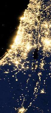
For statistical purposes, the country has three metropolitan areas; Gush Dan-Tel Aviv (population 3,150,000), Haifa (population 996,000), and Beersheba (population 531,600).[58] Some argue that Jerusalem, Israel's largest city with a population of 763,600,[59] and Nazareth,[60] should also be classified as metropolitan areas. In total, Israel has 74 cities, 14 of which have populations of over 100,000. Other forms of local government in Israel are local councils of which there are 144 governing small municipalities generally over 2,000 in population,[61][62] and regional councils of which there are 53, governing a group of small communities over a relatively large geographical area.[61][63]
Israel's population is diverse demographically; 76% Jewish, 20% Arab, and 4% unaffiliated.[64] In terms of religion, 76% are Jewish, 16% Muslim, 2% Christian, 2% Druze, and 4% are unclassified by choice.[65] 8% of Israeli Jews are haredi; 9% are "religious", 12% "religious-traditionalists", 27% are "non-religious traditionalists", and 43% are "secular".[66] Other small, but notable groups in Israel, include Circassians of whom there are approximately 3,000 living mostly in two northern villages, 2,500 Lebanese, and 5,000 Armenians predominantly in Jerusalem.[67][68]
Overshoot index
Israel is ranked 34th in the world in terms of population density with, as noted, a climate of long, hot, rainless summers and relatively short, cool, rainy winters.[51] The Population Matters 2011 overshoot index[69] ranked Israel as the third most dependent region in the World after Singapore and Kuwait.
See also
- Archaeology of Israel
- Kurkar
- Land of Israel
- List of endemic flora of Israel
- National parks and nature reserves of Israel
- Outline of Israel
- Tourism in Israel
- Wildlife of Israel
- Maps of Ancient Israel
References
- 1 2 3 4 5 6 7 8 9 10 11 12 13 14 15 16 17 18 19 20 21 22 23 24 25 26 27 "Israel". CIA World Factbook. Retrieved 8 April 2008.
- 1 2 3 Federal Research Division (2004). Israel A Country Study (Paperback ed.). Kessinger Publishing, LLC. p. 8. ISBN 1-4191-2689-X.
- 1 2 3 "Israel – Geography". U.S. Library of Congress. Retrieved 8 April 2008.
- ↑ An Empire in the Holy Land: Historical Geography of the British Administration in Palestine, 1917–1929, Gideon Biger, St. Martin's Press and Magnes Press, 1994, pp.40–41.
- ↑ An Empire in the Holy Land: Historical Geography of the British Administration in Palestine, 1917–1929, Gideon Biger, St. Martin's Press and Magnes Press, 1994, pp.46–52.
- ↑ An Empire in the Holy Land: Historical Geography of the British Administration in Palestine, 1917–1929, Gideon Biger, St. Martin's Press and Magnes Press, 1994, pp.67–69.
- 1 2 3 4 5 6 7 8 9 10 11 12 13 14 15 16 17 18 19 Figure calculated from other sourced figures in table
- 1 2 http://www.miftah.org/Display.cfm?DocId=14464&CategoryId=4
- ↑ Jerusalem Institute for Israel Studies. "Jerusalem Statistical Yearbook 2009/10" (PDF). Retrieved 5 October 2010.
- ↑ Middle East Forum. "The Politics of Palestinian Demography". Retrieved 5 October 2010.
- 1 2 Office for the Coordination of Humanitarian Affairs. "Barrier Report July 2009. Calculation based on East Jerusalem area of 346km2 being 97% west of the barrier, and 9.5% of the West bank including East Jerusalem being in the Seam Zone" (PDF). Retrieved 5 October 2010.
- 1 2 3 Israel Central Bureau of Statistics. "Israeli Census data" (PDF). Retrieved 5 October 2010.
- 1 2 Israel Central Bureau of Statistics. "Israeli statistical Area data" (PDF). Retrieved 5 October 2010.
- 1 2 B'Tselem. "Separation Barrier Statistics". Retrieved 5 October 2010.
- 1 2 Office for the Coordination of Humanitarian Affairs. "Area C Humanitarian Response Plan Fact Sheet September 2010. Assumes 35,000 Palestinians estimated by B'Tselem to be living in the Seam Zone are included in the 150,000 OCHA estimate." (PDF). Retrieved 5 October 2010.
- ↑ CIA World Factbook. "West Bank population. Based on total area of 5,640km2 including East Jerusalem and excluding water. Figure shown calculated from other figures sourced on page.". Retrieved 5 October 2010.
- ↑ CIA World Factbook. "West Bank population. Assumes CIA World Factbook number excludes Israeli settlers but includes estimated 225k Palestinians living in East Jerusalem". Retrieved 5 October 2010.
- 1 2 CIA World Factbook. "Gaza Strip population. Excludes Israeli settlers, but includes estimated 225k Non-Israeli Palestinians in East Jerusalem". Retrieved 5 October 2010.
- 1 2 3 4 5 6 7 8 9 10 11 12 13 14 15 16 17 18 19 "Israel Topography". U.S. Library of Congress. Retrieved 8 April 2008.
- ↑ "River Restoration". Israel Ministry of the Environment. Retrieved 29 July 2011.
- 1 2 "The coastal plain". Retrieved 26 January 2008.
- ↑ "Makhteshim Country". UNESCO. Retrieved 8 April 2008.
- 1 2 3 4 5 6 7 "Israel's Negev Desert". Archived from the original on 22 February 2008. Retrieved 8 April 2008.
- ↑ "Israel Natural Environment". Geckogo.com.
- 1 2 3 "Geology of Israel". Retrieved 8 April 2008.
- ↑ "Rosh HaNikra". JAFI. Retrieved 8 April 2008.
- ↑ Ferry M.; Meghraoui M.; Karaki A.A.; Al-Taj M.; Amoush H.; Al-Dhaisat S.; Barjous M. (2008). "A 48-kyr-long slip rate history for the Jordan Valley segment of the Dead Sea Fault". Earth and Planetary Science Letters. 260 (3—4): 394–406. Bibcode:2007E&PSL.260..394F. doi:10.1016/j.epsl.2007.05.049.
- 1 2 American Friends of the Tel Aviv University, Earthquake Experts at Tel Aviv University Turn to History for Guidance (October 4, 2007). Quote: The major ones were recorded along the Jordan Valley in the years 31 B.C.E., 363 C.E., 749 C.E., and 1033 C.E. "So roughly, we are talking about an interval of every 400 years. If we follow the patterns of nature, a major quake should be expected any time because almost a whole millennium has passed since the last strong earthquake of 1033." (Tel Aviv University Associate Professor Dr. Shmuel (Shmulik) Marco).
- 1 2 Zafrir Renat, Israel Is Due, and Ill Prepared, for Major Earthquake, Haaretz, 15 January 2010. "On average, a destructive earthquake takes place in Israel once every 80 years, causing serious casualties and damage."
- 1 2 3 4 5 6 7 8 9 10 11 12 13 Avner Rabban; Kenneth G. Holum, eds. (1996). Caesarea Maritima: A retrospective after two millennia. Documenta et Monumenta Orientis Antiqui, V. 21 (Book 21). Brill. p. 23. ISBN 9789004103788. Retrieved 3 April 2015.
- 1 2 3 4 5 6 7 8 9 John L. McKenzie S. J. (1995). Dictionary Of The Bible. New York: Touchstone/Simon & Schuster. p. 208. ISBN 9780684819136. Retrieved 3 April 2015.
- 1 2 3 4 5 6 7 8 Walter Hays (2013). "2013 Review of notable earthquakes in the Mediterranean region". University of Pittsburgh. Retrieved 3 April 2015.
- ↑ http://www.documentacatholicaomnia.eu/03d/0037-0103,_Flavius_Josephus,_De_Bello_Judaico,_EN.pdf
- ↑ "late Roman period - www.emmaus-nicopolis.org".
- ↑ Sharon, 1997, p. 79
- ↑ "Joshua the Stylite, Chronicle composed in Syriac in AD 507 (1882)pp.1-76".
- 1 2 Mohamed Reda Sbeinati; Ryad Darawcheh; Mikhail Mouty (2005). "The historical earthquakes of Syria: an analysis of large and moderate earthquakes from 1365 B.C. to 1900 A.D.". Annals of Geophysics, Vol. 48, N. 3, June 2005. pp. 381, 389–391, 410. Retrieved 3 April 2015.
- ↑ Khalidi, Walid (1992). All That Remains: The Palestinian Villages Occupied and Depopulated by Israel in 1948. Washington D.C.: Institute for Palestine Studies. p. 518. ISBN 0-88728-224-5.
- ↑ Gülru Neci̇poğlu, Julia Bailey, ed. (2009). Frontiers of Islamic Art and Architecture: Essays in Celebration of Oleg Grabar's Eightieth Birthday. Muqarnas, Volume XXV. Brill. p. 82, note 14. ISBN 9789004173279.
- ↑ "The Jaffa Cultural Heritage Project".
- ↑ History
- ↑ Ambraseys 1997, p. 929
- ↑ Kallner-Amiran, D. H. "A Revised Earthquake Catalog of Palestine". Retrieved 8 July 2012.
- ↑ Wachs, Daniel; Levitte, Dov (June 1978), Damage Caused By Landslides During the Earthquakes of 1837 and 1927 in the Galilee Region, Geological Survey of Israel
- ↑ Duff, Douglas V. (1934) Sword for Hire.The Saga of a Modern Free-Companion. John Murray, London. 1st Edition. pp.219–227
- 1 2 3 4 "River Jordan". Encarta. Archived from the original on 31 October 2009. Retrieved 9 September 2010.
- ↑ "Lake Tiberias". Encarta. Archived from the original on 31 October 2009. Retrieved 8 April 2008.
- 1 2 3 "Dead Sea". Archived from the original on 31 October 2009. Retrieved 8 April 2008.
- ↑ "Dead Sea Canal". Retrieved 8 April 2008.
- ↑ Statistical Abstract of Israel, No. 58, 2007
- 1 2 3 4 5 6 7 8 9 10 11 "Climate". U.S. Library of Congress. Retrieved 8 April 2008.
- ↑ "'Mini-tornado' sweeps through western Galilee". Ynetnews. Retrieved 8 April 2008.
- ↑ Bar, Avi (18 January 2009). "Israel`s largest-ever reserve of natural gas discovered off Haifa coast". Haaretz.
- 1 2 3 "Rural Settlement Geography of Israel" (PDF). Indiana State University. Retrieved 7 April 2008.
- ↑ "Israel considers building artificial islands – Israel Environment". Ynetnews. 20 June 1995.
- ↑ Ben, Ilan (17 June 2012). "Short on space, Israel looks to artificial islands". The Times of Israel.
- ↑ "CBS: Israel home to 8 Million citizens". Ynetnews.
- ↑ "Localities, Population, and Density" (PDF). Retrieved 2 July 2007.
- ↑ "Jerusalem: From Town to Metropolis". University of Southern Maine. Archived from the original on 7 March 2008. Retrieved 8 April 2008.
- ↑ "Initiated Development in the Nazareth Region". Archived from the original on 12 November 2007. Retrieved 8 April 2008.
- 1 2 Mahler, Gregory S. Politics and Government in Israel: The Maturation of a Modern State. Rowman & Littlefield. p. 229.
- ↑ Troen, Selwyn Ilan; Noah Lucas. Israel: The First Decade of Independence. SUNY Press. p. 496.
- ↑ Herzog, Hanna. Gendering Politics: Women in Israel. University of Michigan Press. p. 22.
- ↑ "Population by population group" (PDF). Israel CBS. Retrieved 8 April 2008.
- ↑ "Population by religion" (PDF). Israel CBS. Retrieved 8 April 2008.
- ↑ "Social Survey" (in Hebrew). Israel CBS. 2006. Retrieved 8 April 2008.
- ↑ "Circassians in Israel". Retrieved 8 April 2008.
- ↑ "The Armenian Quarter". Jewish Virtual Library. Retrieved 8 April 2008.
- ↑ "Overshoot Index 2011" (PDF). Population Matters. Retrieved 19 August 2014.
External links
| Wikimedia Commons has media related to Geography of Israel. |
 Wikimedia Atlas of Israel
 Geographic data related to Israel at OpenStreetMap
- Geography and Climate at the Israel Ministry of Foreign Affairs website
- Geography and Nature at the Israel Ministry of Tourism website
- Geography of Israel at the Jewish Virtual Library
- Israel: Maps and Views at DMOZ
| Districts |  | |
|---|---|---|
| Bodies of water | ||
| Occupied territories | ||
| Cities | ||
| Regions | ||
| Bordering nations | ||
| Archaeology | ||