Geography of Mongolia
|
The map showing the major cities and the neighbouring countries of Mongolia | |
| Continent | Asia |
|---|---|
| Region | East Asia |
| Coordinates | 46°0′N 105°0′E / 46.000°N 105.000°E |
| Area | Ranked 19 |
| • Total | 1,564,116[1] km2 (603,909 sq mi) |
| • Land | 99.3% |
| • Water | 0.7% |
| Borders | Russia, China |
| Highest point | Khüiten Peak (4,374 metres) |
| Lowest point | Hoh Nuur (560 metres) |
| Longest river | Orkhon River |
| Largest lake | Uvs Lake by area, Khövsgöl Nuur by volume |
| Climate | desert; continental |
| Terrain | vast semidesert and desert plains, grassy steppe, mountains in west and southwest |
| Natural Resources | oil, coal, copper, molybdenum, tungsten, phosphates, tin, nickel, zinc, fluorspar, gold, silver, iron |
| Natural Hazards | dust storms; grassland and forest fires; drought |
| Environmental Issues | limited natural freshwater; the burning of soft coal for power; poor enforcement of environmental laws; severe air pollution in Ulaanbaatar; deforestation, overgrazing, soil erosion; desertification and poor mining practise |

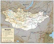
Mongolia is a landlocked country in Central Asia and East Asia, located between China and Russia. The terrain is one of mountains and rolling plateaus, with a high degree of relief. The total land area of Mongolia is 1,564,116 square kilometres. Overall, the land slopes from the high Altay Mountains of the west and the north to plains and depressions in the east and the south. The Khüiten Peak in extreme western Mongolia on the Chinese border is the highest point (4,374 metres). The lowest is 518 metres, an otherwise undistinguished spot in the eastern Mongolian plain. The country has an average elevation of 1,580 metres. The landscape includes one of Asia's largest freshwater lakes (Lake Khövsgöl), many salt lakes, marshes, sand dunes, rolling grasslands, alpine forests, and permanent mountain glaciers. Northern and western Mongolia are seismically active zones, with frequent earthquakes and many hot springs and extinct volcanoes. The nation's closest point to any ocean is approximately 645 kilometres (401 mi) from the country's easternmost tip bordering northern China to Jinzhou in Liaoning province, China along the coastline of the Bohai Sea.
Mountain regions
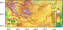
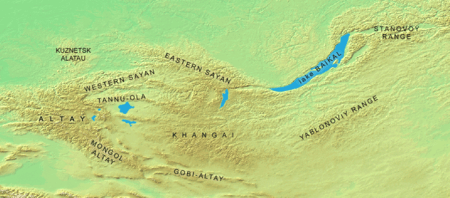
Mongolia has two major mountain ranges. The highest is the Altai Mountains, which stretch across the western and the southwestern regions of the country on a northwest-to-southeast axis. The highest peak in the country, Khüiten Peak at 4734 metres, is in the Altai range.[2]
The Khangai Mountains, mountains also trending northwest to southeast, occupy much of central and north-central Mongolia. These are older, lower, and more eroded mountains, with many forests and alpine pastures. Much of eastern Mongolia is occupied by a plain, and the lowest area is a southwest-to-northeast trending depression that reaches from the Gobi Desert region in the south to the eastern frontier.
Rivers and lakes
Some of Mongolia's waterways drain to the oceans, but many finish at Endorheic basins in the deserts and the depressions of Inner Asia. Rivers are most extensively developed in the north, and the country's major river system is that of the Selenge, which drains via Lake Baikal to the Arctic Ocean. Some minor tributaries of Siberia's Yenisei River, which also flows to the Arctic Ocean, rise in the mountains of northwestern Mongolia. In northeastern Mongolia the Onon River drains into the Pacific Ocean through the Shilka River in Russia and the Amur (Heilong Jiang) rivers, forming the tenth longest river system in the world.
Many rivers of western Mongolia end at lakes in the Central Asian Internal Drainage Basin, most often in the Great Lakes Depression, or at Hulun Lake, Ulaan Lake or Ulungur Lake.[3] The few streams of southern Mongolia do not reach the sea but run into lakes or deserts.
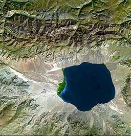
Mongolia's largest lake by area, Uvs Lake is in the Great Lakes Depression. Mongolia's largest lake by volume of water, Khövsgöl Nuur, drains via the Selenge river to the Arctic Ocean. One of the most easterly lakes of Mongolia, Hoh Nuur, at an elevation of 553 metres, is the lowest point in the country.[4] In total, the lakes and rivers of Mongolia cover 10,560 square kilometres, or 0.67% of the country.[1]
Climate

Overview
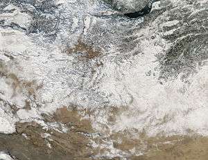
Mongolia is high, cold, and dry. It has an extreme continental climate with long, cold winters and short summers, during which most precipitation falls. The country averages 257 cloudless days a year, and it is usually at the center of a region of high atmospheric pressure. Precipitation is highest in the north, which averages 200 to 350 millimeters (7.9 to 13.8 in) per year, and lowest in the south, which receives 100 to 200 millimeters (3.9 to 7.9 in). The extreme south is the Gobi Desert, some regions of which receive no precipitation at all in most years. The name Gobi is a Mongol word meaning desert, depression, salt marsh, or steppe, but which usually refers to a category of arid rangeland with insufficient vegetation to support marmots but with enough to support camels. Mongols distinguish Gobi from desert proper, although the distinction is not always apparent to outsiders unfamiliar with the Mongolian landscape. Gobi rangelands are fragile and are easily destroyed by overgrazing, which results in expansion of the true desert, a stony waste where not even Bactrian camels can survive.
Average temperatures over most of the country are below freezing from November through March and are about freezing in April and October. January and February averages of 20 °C (68 °F) are common, with winter nights of 100 °C (212 °F) occurring most years. Summer extremes reach as high as 38 °C (100.4 °F) in the southern Gobi region and 33 °C (91.4 °F) in Ulaanbaatar. Most of Mongolia is covered by discontinuous permafrost (grading to continuous at high altitudes), which makes construction, road building, and mining difficult. All rivers and freshwater lakes freeze over in the winter, and smaller streams commonly freeze to the bottom. Ulaanbaatar lies at 1,351 meters (4,432 ft) above sea level in the valley of the Tuul River. Located in the relatively well-watered north, it receives an annual average of 310 millimetres (12.2 in) of precipitation, almost all of which falls in July and in August. Ulaanbaatar has an average annual temperature of −2.9 °C (26.8 °F) and a frost-free period extending on the average from mid-may to late August.
Mongolia's weather is characterized by extreme variability and short-term unpredictability in the summer, and the multiyear averages conceal wide variations in precipitation, dates of frosts, and occurrences of blizzards and spring dust storms. Such weather poses severe challenges to human and livestock survival. Official statistics list less than 1% of the country as arable, 8 to 10% as forest, and the rest as pasture or desert. Grain, mostly wheat, is grown in the valleys of the Selenge river system in the north, but yields fluctuate widely and unpredictably as a result of the amount and the timing of rain and the dates of killing frosts.
Zud

Although winters are generally cold and clear, and livestock can survive, under various weather conditions livestock are unable to graze and die in large numbers. A winter in which this occurs is known as a zud; causes include blizzards, drought, extreme cold, and freezing rain. Such losses of livestock, which are an inevitable and, in a sense, normal consequence of the climate, have made it difficult for planned increases in livestock numbers to be achieved.
Seasonal blizzards
Severe blizzards can occur in the region. The winters of 1970–1971, 2000–2001, 2008–2009 and 2009–2010 were particularly harsh, featuring extremely severe zuds.
The blizzards of December 2011 blocked many roads, and killed 16,000 livestock and 10 people.[5][6] The Mongolian State Emergency Commission said it was the coldest winter in 30 years and, like the preceding harsh summer drought,[5][6] could have been the result of global warming. The United Nations provided major aid due to the high level of damage caused.[7]
In the snowstorms between the 8 and 28 May 2008, 21 people were killed and 100 others went missing in seven provinces in eastern Mongolia.[8][9][10] The toll finally reached at least 52 people and 200,000 livestock by the end of June.[11] Most of the victims were herders who froze to death along with their livestock.[8] It was the worst cold snap since the founding of the modern state in 1922.
Snowstorms in December 2009–February 2010 also killed 8,000,000 livestock and 60 people.[12]
Ecoregions
- Altai montane forest and forest steppe
- Khangai Mountains conifer forests
- Selenge-Orkhon forest steppe
- Sayan montane conifer forests
- Trans-Baikal conifer forests
- Daurian forest steppe
- Mongolian-Manchurian grassland
- Altai alpine meadow and tundra
- Khangai Mountains alpine meadow
- Sayan Alpine meadows and tundra
- Alashan Plateau semi-desert
- Eastern Gobi desert steppe
- Gobi desert
- Gobi Lakes Valley desert steppe
- Great Lakes Basin desert steppe
- Junggar Basin semi-desert
Area and boundaries
Area:
total:
1,564,116 km2
land:
1,553,556 million km2
water:
10,560 km²
Area - comparative: slightly smaller than Quebec, slightly larger than Alaska
Land boundaries:
total:
8,220 km
border countries:
China 4,677 km, Russia 3,543 km
Coastline: 0 km (landlocked)
Maritime claims: none (landlocked)
Elevation extremes:
lowest point:
Hoh Nuur 518 m
highest point:
Khüiten Peak 4,374 m
Resources and land use
Natural resources: oil, coal, copper, molybdenum, tungsten, phosphates, tin, nickel, zinc, fluorspar, gold, silver, iron
Land use:
arable land:
9.10%
permanent crops:
0%
other:
99.61% (2011)
Irrigated land: 843 km² (2011)
Total renewable water resources: 34.8 km 3 (2011)
Antipodes
Much of central and western Mongolia, including Ulaanbaatar, is antipodal to southern Patagonia. See Geography of Chile#Antipodes and Geography of Argentina#Antipodes for details.
See also
References
- 1 2 "Mongolia". The World Factbook. CIA.
- ↑ "Tavan Bogd Uul, Mongolia/China". Peakbagger.com.
- ↑ "Rivers and Water". Mongolia Travel Guide. Retrieved 26 November 2016.
- ↑ Central Asian Review, Volume 15. Central Asian Research Centre. 1967. Retrieved 26 November 2016.
- 1 2
- 1 2
- ↑
- 1 2
- ↑ http://english.peopledaily.com.cn/90001/90777/90851/6420239.html
- ↑
- ↑ http://www.channelnewsasia.com/stories/afp_asiapacific/view/351407/1/.html
- ↑ http://ubpost.mongolnews.mn/index.php?option=com_content&task=view&id=4205&Itemid=36
 This article incorporates public domain material from the Library of Congress Country Studies website http://lcweb2.loc.gov/frd/cs/.
- This article incorporates public domain material from the CIA World Factbook website https://www.cia.gov/library/publications/the-world-factbook/index.html.
External links
- (Mongolian) Administration of Land Affairs, Geodesy and Cartography
- (English) (Mongolian) Official government site - Institute of Meteorology and Hydrology
- (English) (Mongolian) Official government site - Mineral Resources Authority
- (English) (Mongolian) Official government site - Water Agency of Mongolia
- Limnological Catalogue of Mongolian Lakes
- GEOLOGY OF THE KHARKHIRAA UUL, MONGOLIAN ALTAI
Mongolia articles | |||||||
|---|---|---|---|---|---|---|---|
| History |
|  | |||||
| Geography | |||||||
| Politics | |||||||
| Economy | |||||||
| Society |
| ||||||
| |||||||
Coordinates: 46°00′N 105°00′E / 46.000°N 105.000°E