Glastonbury–Rocky Hill Ferry Historic District
Not to be confused with Rocky Hill Historic District.
|
Glastonbury-Rock Hill Ferry Historic District | |
 | |
  | |
| Location | Roughly along Tryon St., Ferry Ln. and Glastonbury Ave., Meadow and Riverview Rds., Glastonbury, Connecticut |
|---|---|
| Coordinates | 41°39′46″N 72°37′19″W / 41.66278°N 72.62194°WCoordinates: 41°39′46″N 72°37′19″W / 41.66278°N 72.62194°W |
| Area | 230 acres (93 ha) |
| Architect | multiple |
| Architectural style | Colonial, Federal, et al. |
| NRHP Reference # | 05001046[1] |
| Added to NRHP | September 21, 2005 |
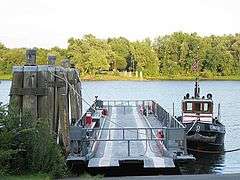
The Glastonbury-Rocky Hill Ferry Historic District is a historic district in Glastonbury and Rocky Hill, Connecticut. It includes the ferry landings and water traversed by the Rocky Hill – Glastonbury Ferry, one of the longest-running ferry services the nation.[2] Included in this are the farmscapes of the Great Meadows in South Glastonbury that preserve 17th-century land use patterns and Colonial and Greek Revival farmhouses, as well as the homes of shipbuilders and merchant traders near the two landings, including several examples of Colonial and Italianate architecture.[3]
The district was listed on the National Register of Historic Places in 2005.[1]
See also
- Gales Ferry, also NRHP-listed in CT
- Hadlyme Ferry Historic District, also NRHP-listed in CT
- National Register of Historic Places listings in Hartford County, Connecticut
References
- 1 2 National Park Service (2009-03-13). "National Register Information System". National Register of Historic Places. National Park Service.
- ↑ Jan Cunningham (December 30, 2005). "National Register of Historic Places Registration: Glastonbury-Rocky Hill Ferry Historic District" (PDF). National Park Service. and Accompanying 32 photos, from 2002 and 2004 (captions given on page 28 of text document)
- ↑ New Listings on the National Register, Connecticut Trust For Historic Preservation
| Topics | |
|---|---|
| Lists by states |
|
| Lists by insular areas | |
| Lists by associated states | |
| Other areas | |
| |
This article is issued from Wikipedia - version of the 11/26/2016. The text is available under the Creative Commons Attribution/Share Alike but additional terms may apply for the media files.