Golaghat
| Golaghat গোলাঘাট | |
|---|---|
| City | |
 | |
 Golaghat  Golaghat Location in Assam, India | |
| Coordinates: 26°31′N 93°58′E / 26.52°N 93.97°ECoordinates: 26°31′N 93°58′E / 26.52°N 93.97°E | |
| Country |
|
| State | Assam |
| Region | Upper - Assam |
| District | Golaghat |
| Golaghat Municipal Board | 1920[1] |
| Government | |
| • Body | Golaghat Municipality Board |
| • Deputy Commissioner | Gaurav Bothra, IAS |
| Elevation | 95 m (312 ft) |
| Population (2011) | |
| • Total | 60,782 |
| Languages | |
| • Official | Assamese |
| Time zone | IST (UTC+5:30) |
| PIN |
785 621 (Golaghat Central) - Head Office
|
| Telephone code | 03774 |
| ISO 3166 code | IN-AS |
| Vehicle registration | AS - 05 - XX - XXXX |
| Legislature type | Municipality |
| Climate | Semi-Arid (Köppen) |
| Precipitation | 500 millimetres (20 in) |
| Avg. annual temperature | 26 °C (79 °F) |
| Avg. summer temperature | 35 °C (95 °F) |
| Avg. winter temperature | 06 °C (43 °F) |
| Website |
www |
Golaghat (Pron: ˌgəʊləˈgɑ:t) which was one of the largest subdivisions of Assam later, elevated to the position of a full-fledged district of Assam on 15 August 1987, is the headquarters of Golaghat district and is a sister town to Jorhat which is about 55 km away.
The place had been elevated to a subdivision away back in 1846. It has the earliest post/mail service and telegraphic communication systems in Assam that dates back to 1876[2]
Golaghat has one of the oldest social - literature/rhetorical congresses of Assam. The Golaghat Sahitya Sabha is one of the oldest congresses of Asam Sahitya Sabha, started in 1918. It has been a District Headquarters since 1987. It is the only place in Assam to have SAI - STC after Guwahati.
Divisions
Golaghat has been divided into following divisions:
- Golaghat Central
- Golaghat East
- Golaghat North
- Golaghat South
- Golaghat West
- Morangi
Etymology
The name Golaghat ('Gola' which means shop and 'Ghat' meaning the landing point of river ferry) originated from the shops established by the 'Marwari' businessmen during the mid-20th century at the bank of river Dhansiri near present Golaghat town.
History
Stone inscription of Nagajari Khanikar gaon of Sarupathar, dating back to the 5th century, reveals that there was an independent kingdom in Doyang - Dhansiri valley and relics of ramparts, brick structures, temples, tanks etc. discovered in these area confirms the presence of a kingdom during 9th and 10th century.
The Doyang – Dhansiri valley came under the rule of Ahom's during the 16th century. Prior to that, this part was ruled by the Kacharis known as Herombial. During Ahom rule this area was under 'Morongi – Khowa Gohain', an administrative officer.
Golaghat during British Rule
After British took possession of Assam, Doyang – Dhansiri valley was included under the newly formed Golaghat subdivision of Sibsagar District in 1846. Golaghat was one of the largest subdivisions of Assam which was later, elevated to the position of a full-fledged district of Assam on 15 August 1987. Golaghat boasts of having one of the earliest post/mail service and telegraphic communication systems.
The earliest head post offices of the Assam Circle of British Assam were located in Golaghat besides Debrughur, Gouhati, Jorhat, Nowgaon, Sibsagar, Shillong and Tezpore (spellings as appear in the book - Glimpse of Assam).[3] Much later after telegraph lines had been stretched between Calcutta and Guwahati in 1869; Golaghat got its speaking wires' system in and around 1876. The telegraphic lines (speaking wires) were stretched to connect Golaghat with Kohima (in Nagaland), Shillong with Guwahati, Sibsagar with Nazira and Dibrugarh with Makum.[3]
In British Assam, Golaghat derived its importance chiefly because of having advanced communication systems during that time and on account of its connection by road with Kohima.[4]
Golaghat also has one of the oldest railway lines in Assam.[5] Text noted from the book Glimpse of Assam written by Mrs. SR Ward in 1884 states that, Mr. Bryers who was then the Chief of Cachar and Assam Railway Survey succeeded in finding a railway route that would be carried up the Dhansiri valley to Golaghat... thus giving Assam direct railway communication with Chittagong and Calcutta.[5]
Golaghat is known for its notable contribution in India's Freedom Struggle, Arts, Literature and Culture and Sports
- Kushal Konwar, Kamala Miri, Dwariki Das, Biju Vaishnav, Sankar Chandra Barua, Shri Tara P. Barooah, Maheshwar Barooah, Rajendra Nath Barua, Gaurilal Jain, Ganga Ram Bormedhi and Dwarikanath Goswami are eminent freedom fighters of the town.
- The Golaghat Sahitya Sabha is one of the oldest congresses of Asam Sahitya Sabha, started in 1918.
- The most prominent writer of the 19th century who hailed from Golaghat was Hem Chandra Barua, the writer of first Assamese dictionary Hemkosh.
- Ghanashyam Barua of Golaghat, who was also famous in the field of politics as the first Central Minister of Assam, translated William Shakespeare's The Comedy of Errors into the Assamese language along with three of his partners.
- Golaghat has played an important role in the field of sports in Assam. The tea town has produced several National and International players of repute in athletics, table tennis, tennis, boxing and football. Sports Authority of India has a training centre at SAI Sports Complex in Golaghat.
- Golaghat Tennis Club is one of the oldest in Assam. Presently, besides two clay courts in Golaghat Tennis Complex, there are also 2 lawn courts at Kushal Konwar Memorial Trust complex. The old club is now equipped with modern infrastructure facilities that includes the facility of floodlight system and qualified coach. The club has been organising North East Tennis Championship and other AITA tournaments regularly since 1987.
- The Lawn court at Kushal Konwar Memorial Trust Complex located near Mission Circle in Golaghat is the only grass court of Assam.
- Numaligarh Refinery,located at Morangi Area, Numaligarh, Golaghat district
Geography
Golaghat is located at 26°31′N 93°58′E / 26.52°N 93.97°E.[6] It has an average elevation of 95 metres (311 feet).
Demographics
As of 2001 India census,[7] Golaghat had a population of 33,021. Males constitute 53% of the population and females 47%. Golaghat has an average literacy rate of 82%, higher than the national average of 59.5%. Male literacy is 84%, and Female literacy is 79%. In Golaghat, 11% of the population is under 6 years of age.
-

Golaghat traffic circle
-

Golaghat Mission School
-

Golaghat traffic circle with musical fountain on display
-

Golaghat Baptist Church
Education
Golaghat is known for many literary intellects who have made outstanding contributions to Assamese literature. The place has good old institutions which have been credited with students' high academic performance and record scores in the past when being compared to other institution equivalents of similar repute in Assam.
Primary and secondary education in Golaghat are offered by various schools affiliated to one of the boards of education, such as the HSLC of SEBA, AISSE of CBSE and ICSE of CISE. Schools in Golaghat are either government run or are private (both aided and un-aided by the government). After completing their high or secondary education, students either attend Higher Secondary School Leaving Certificate (HSSLC) through Degree/Junior College affiliated to AHSEC or All India Senior Secondary School Examination (AISSSE) affiliated to CBSE or Indian School Certificate (ISC) affiliated to CISCE in one of the three streams – Arts / Humanities, Commerce or Science with combinational electives.
Following are a few of the institutes:
College
Colleges - Level: Undergraduate & Postgraduate Degree and HSSLC (Jr.)
- Biseswar Phukan Junior College
- College of Teacher Education (B.ed College) - CTE Golaghat
- Debraj Roy College - DR
- Don Bosco College
- Furkating College
- Golaghat Commerce College - Golaghat Commerce
- Golaghat Jatiya Mahavidyalaya
- Golaghat Law College
- H.P.B. Girls College
- Indian Technical Institute, Golaghat
- Pragjyotika Academy
- Morangi College
- Reliance Junior College
- Residential Girls' Polytechnic - RGP Golaghat
School
Schools - Level: Primary & High Schools and Higher or Senior Secondary
Primary
- No. 1 Town Model School
- No. 2 Town Model School
- No. 3 Town Chandmari School
- Golaghat Sishu Bhavan
High School and Higher or Senior Secondary
- Bengali School (SEBA - HSLC)
- Christian High School, Golaghat (SEBA - HSLC)
- Dandadhar Barooah Girls High School (SEBA - HSLC)
- Fallagani High School (SEBA - HSLC)
- Golaghat Jatiya Vidyalaya (SEBA - HSLC)
- Government Boys Bezbarooah Higher Secondary School (SEBA - HSLC, AHSEC - HSSLC)
- Hindi School (SEBA - HSLC)
- Jawahar Navodaya Vidyalaya, Golaghat - JNV Golaghat (CBSE - AISSE/AISSSE)
- Kendriya Vidyalaya - KV Golaghat (CBSE - AISSE)
- Marshneil Academy
- Morangi Dina Nath High School
- Montessori School, Golaghat - KKBB: Kushal Konwar Balya Bhawan (SEBA - HSLC)
- Phanidhar Bordoloi High School (Town High School) "(SEBA - HSLC)"
- Pulibor Vidyapith, (SEBA - HSLC, AHSEC - HSSLC)
- Rodhola high school (SEBA - HSLC)
- Sacred Heart High School - Golaghat (SEBA - HSLC)
- Saint Mary's High School, Doigrung (SEBA - HSLC)
- Shankardev Shisu/vidya Niketan
- Sri Sathya Sai Vidya Vihar (CBSE - AISSE)
- Town Girls High School, Golaghat (SEBA - HSLC)
- Vivekananda Kendra Vidyalaya - VKV Golaghat (CBSE - AISSE/AISSSE)
Creche/Daycare for children
- Golaghat Sishu Bhavan school, a daycare for infants, babies and young school going children (post-school hours), near the Deputy Commissioner's office and the district and sessions court.
- Bachpan Play School[8]
- Blue Valley
- Eurokids
- Kidzee
- Kids Paradise etc. are some of the play school
Others
- Ajanta Kala Manadal: School of dance.
- KVK: Krishi Vigyan Kendra (ICAR - AAU)
- Maheshwar Barooah Sangeet Mahavidyalaya: Music college
- Mayur Kala Kendra
- NEiiT: North East Institute of Information Technology
- Rupaban Mahavidyalaya: College of music and dance
Transportation
- Air
Rowriah Airport is the nearest airport from Golaghat.
- Rail
The Golaghat railway station is located at Bet Mahal, and the main railhead is Furkating junction on Lumding–Dibrugarh section of Northeast Frontier Railway, about 10 kilometers from Golaghat municipal area. There are daily and weekly trains running through the Furkating junction to all important cities of the country.
- Road
Golaghat is well connected by roadways to all the cities and towns of Assam. The National Highway 39 (NH 39) starts from Numaligarh, passes near Golaghat town which is linked by GD Road and GF Road.
Places of Interest

- Kaziranga National Park: Kazirônga is a national park in the Golaghat and Nagaon districts of the state of Assam, India. A World Heritage Site, the park hosts two-thirds of the world's great one-horned rhinoceroses. Kaziranga boasts the highest density of tigers among protected areas in the world and was declared a tiger reserve in 2006. The park is home to large breeding populations of elephants, wild water buffalo, and swamp deer. Kaziranga is recognized as an Important Bird Area by BirdLife International for conservation of avifaunal species. Compared to other protected areas in India, Kaziranga has achieved notable success in wildlife conservation. Located on the edge of the Eastern Himalaya biodiversity hotspot, the park combines high species diversity and visibility. It is a vast expanse of tall elephant grass, marshland, and dense tropical moist broadleaf forests, crisscrossed by four major rivers, including the Brahmaputra, and the park includes numerous small bodies of water. Kaziranga has been the theme of several books, songs, and documentaries. The park celebrated its centennial in 2005 after its establishment in 1905 as a reserve forest.
- Garampani Wildlife Sanctuary : It is a 6.05-square-kilometre (2.34 sq mi) wildlife sanctuary located in Karbi Anglong district, Assam, India. It is 25 km (16 mi) from Golaghat. It is one of the oldest Sanctuary containing Hot water spring and Waterfalls and surrounded by Nambor Sanctuary having 51 rare species of orchid. Visit to see tiger, elephant, gaur, bear, sambar, barking deer, rhesus macaque,hoolock gibbon, wild pig, The great pied hornbill, hill myna, python, cobra, monitor lizards, etc. Best season for visit : November to April.

- Science and Nature Museum (Uncle Robin's Children Museum): The museum is located on the Mission Road in Golaghat and within the residence of late Dr Robin Banerjee, a naturalist of International repute. The museum is full of dolls, artifacts, mementos, movies and other personal collections of Dr Banerjee's lifetime. There are 587 dolls and 262 other show pieces. They have mostly been presented by admirers and children during his many trips to abroad and within the country as well.
.jpg)
- Golaghat Gymkhana: The new Golaghat Gymkhana is an architecture built in 1910 and is a clubhouse offering a complete package food and board with a restaurant and a bar, a swimming pool, a gymnasium and even a billiards room. Raibahadur Ghanashyam Baruah, had constructed the bungalow after the family ventured into the tea business. Being a tea-town of Assam, Golaghat had its own Gymkhana Club much like Jorhat which was later destroyed during the Quit India Movement.[9] It was then the centre of entertainment and merry-making for the Military personnel.
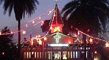
- Golaghat Baptist Church: Golaghat Baptist Church, one of the oldest and biggest Baptist Churches in Assam, which celebrated its Centenary Jubilee in 1999, came into being in December 1898. The pioneering man in this Great Venture was Dr. O. L. Swanson, a missionary from America, who had come to Assam in 1893 along with his wife. Dr. Swanson was assisted by a number of local people.
- GATS - Golaghat Amateur Theatre Society: It is a Theatre cum Local Town Convention Hall that is located at the Centre of the City. Most of the seminars, conferences, theatres, meetings and other workshops are conducted in GATS Hall.
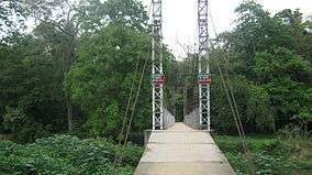
- Dhansiri river ghat: A walk down the Dhansiri bridge towards the river offers a very beautiful sight. It is a popular picnic spot close to the town.
- Jamuna Water Park: It is a Public Park within the city that provides water boating facility for the locals and the tourists who visit the city.
- Jamuna Water Body: It is an especialized region of the Jamuna Water Park that has been preserved and is not open to public boating that has a rich recorded history of abundant flora and fauna plantations.
- Japixojia lake (beel): This large natural water body is about 30 minutes drive from Golaghat town, located near the district jail of Golaghat. The japixojia lake is a very lovely spot, with lush tea gardens lining the borders of the vast expanses of water. The lake is visited by many migratory birds as well as home to various all season birds.
- Doss & Co. is one of the largest and oldest Department Store in Assam and largest within the City, that has been established away back during British Raj which is still present in the Centre of the City in its original building complex. The Department Store has many divisions that houses home appliances, electronics, and additionally select other lines of products such as paint, hardware, toiletries, cosmetics, photographic equipment, jewellery, toys, and sporting goods amongst others. A branch of this Store is also present in the sister town of Jorhat which is also equally huge and old.
- Athkheliya Namghar: It is one of the prominent religious places of Assam. The namghar was built in 1681 by Ahom king Gadapani. It is situated at the bank of river Kakodonga in Bosagaon of Golaghat district.
- Nambor - Doigrung Wildlife Sanctuary: Nambor - Doigrung Wildlife Sanctuary, spreading in 97 square kilometres (37 sq mi). in 3 blocks, is located in Morangi, Golaghat district and is famous for Hot water springs and one can easily sight gaur and hoolock gibbon here.
Sports
Sport's Clubs
- Golaghat Tennis Club: Being one of the oldest clubs in Assam, the GTC has 2 clay courts in Golaghat Tennis Complex besides two lawn courts at Kushal Kunwar Memorial Trust complex in Mission Circle. The club equipped with modern infrastructure facilities has also Floodlight stipulation - the facility that provides broad-beamed, high-intensity artificial lights for outdoor playing in low-light conditions, and qualified coaches. The club has been organising North East Tennis Championship and other AITA tournaments regularly since 1987.
- The Indoor Stadium: The premises confined near to Mission Circle, the Table Tennis and Badminton Indoor Stadium is equipped with four table tennis boards and two badminton courts. It is a great professional cum recreational sports centre for sports enthusiast.
- The Boxing Club: Golaghat boxing club is one of the pioneering boxing clubs of Assam. The club in the Amolapatty - Old is a centre for boxing events.
- The Swimming Club: Located next to the indoor stadium near to Mission Circle the swimming pool managed by District's Sport Office, has training facility for all age groups conducted by trained and experienced coaches.
- Golaghat Stadium: It is a fully built stadium with galleries and sitting capacity of 4000 people. Good Cricket pitch which is however also used to host football matches.The stadium complex houses two volleyball courts, two boxing rings, a cricket ground, a football ground, a twin-crease indoor cricket practice stadium and a four star guest house-cum-gallery.The indoor cricket practice stadium is built with materials imported from Australia.
- Golaghat District Carrom Association (GDCA) is the only platform for the carrom players of the DIstrict.
Prominent Localities
Few prominent localities of Golaghat are:
- Amolapatty - New {Residential Locality}
- Amolapatty - Old {Residential Locality}
- Arengapara - {Residential cum Commercial Locality}
- Baagicha Ali {Residential Locality}
- Begenakhuwa {Residential cum Commercial Locality}
- Chandan Nagar {Residential Locality}
- Chandmari {Residential}
- Chitra Sen Kakoty Path {Residential Locality}
- Court Road {Residential cum Commercial Locality}
- Junaaki Nagar {New development area}
- Krishna Nagar (Residential area located on the south)
- Marwari Patty - {Residential Locality}
- Mission Road {Mostly residential however exist few commercial establishments}
- Paltanpatty - {Residential Locality}
- Santipur {Residential Locality}
- Srimanta Nagar {Residential Locality}
- Station Road - Betmahal {Residential cum Commercial Locality}
- Tapan Nagar-{Mostly residential however exist few commercial establishments}
Notable personalities
- Aideu Handique, Assamese actress
- Ajanta Neog,politician
- Hemchandra Goswami, Eminent writer, poet, historian, teacher and a linguist
- Swargajyoti Barooah, Assamese actress
- Nilmani Phookan, Eminent writer, poet
- Chandradhar Barua, Eminent writer, poet
- Atul Bora, Politician
- Debo Prasad Barooah, Academician, Historian, Ex-VC Gauhati University
- Hiren Gohain, Literary critic, social scientist
- Kushal Konwar, Freedom fighter
- Munin Barua, prominent Assamese film maker
- Syed Abdul Malik, Writer
- Digbijoy Nath, Electronic Device Engineer, Professor at IISc
- Nagen Saikia, Writer
- Gunaram Khanikar, Herbal Medicine Expert
- Robin Banerjee, noted wildlife expert, environmentalist, painter, photographer and documentary filmmaker
- Rana Tamooly, Assamese actor
Politics
Golaghat is part of Kaliabor (Lok Sabha constituency).[10]
References
- ↑ http://www.telegraphindia.com/1150119/jsp/northeast/story_9079.jsp#.V0OXAZMrIcg
- ↑ A Glimpse of Assam
- 1 2 A Glimpse of Assam
- ↑ A Glimpse of Assam
- 1 2 A Glimpse of Assam
- ↑ Falling Rain Genomics, Inc - Golaghat
- ↑ "Census of India 2001: Data from the 2001 Census, including cities, villages and towns (Provisional)". Census Commission of India. Archived from the original on 2004-06-16. Retrieved 2008-11-01.
- ↑ "Bachpan Play School". Bachpanglobal.com. Retrieved 2015-08-22.
- ↑ https://books.google.com/books?id=gZmusO1pWjUC&pg=PA123&lpg=PA123&dq=golaghat+gymkhana&source=bl&ots=x0xbBjK00a&sig=jIdGXVBqls0YIVpN28TM6z6qNIY&hl=en&sa=X&ei=YyMLU9DYCsGGrgfWxIDQDQ&ved=0CDIQ6AEwAjgK#v=onepage&q=golaghat%20gymkhana&f=false
- ↑ "List of Parliamentary & Assembly Constituencies" (PDF). Assam. Election Commission of India. Retrieved 2008-10-06.
| Topics | |
|---|---|
| History | |
| Districts & Divisions |
|
| Geography | |
| Culture | |
| Arts, Literature, Music Cinema |
|
| People | |
| Notable surnames |
|
| Urban centres | |
| |