Gove City, Kansas
| Gove City, Kansas | |
|---|---|
| City | |
 Location within Gove County and Kansas | |
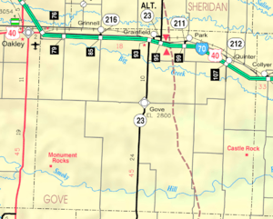 KDOT map of Gove County (legend) | |
| Coordinates: 38°57′34″N 100°29′14″W / 38.95944°N 100.48722°WCoordinates: 38°57′34″N 100°29′14″W / 38.95944°N 100.48722°W | |
| Country | United States |
| State | Kansas |
| County | Gove |
| Area[1] | |
| • Total | 0.25 sq mi (0.65 km2) |
| • Land | 0.25 sq mi (0.65 km2) |
| • Water | 0 sq mi (0 km2) |
| Population (2010)[2] | |
| • Total | 80 |
| • Estimate (2015)[3] | 76 |
| • Density | 320/sq mi (120/km2) |
| Time zone | Central (CST) (UTC-6) |
| • Summer (DST) | CDT (UTC-5) |
| FIPS code | 20-27125 [4] |
Gove City, more commonly known as just Gove, is a city in and the county seat of Gove County, Kansas, United States.[5] As of the 2010 census, the city population was 80.[6]
History
Gove City was founded in 1885.[7] It was designated county seat in 1886, and incorporated in 1888.[8] It is named for Grenville Gove, member of the 11th Regiment Kansas Volunteer Cavalry.[9]
Geography
Gove City is located at 38°57′34″N 100°29′14″W / 38.95944°N 100.48722°W (38.959576, -100.487316).[10] According to the United States Census Bureau, the city has a total area of 0.25 square miles (0.65 km2), all of it land.[1]
Climate
The climate in this area is characterized by hot, humid summers and generally mild to cool winters. According to the Köppen Climate Classification system, Gove City has a humid subtropical climate, abbreviated "Cfa" on climate maps.[11]
Demographics
| Historical population | |||
|---|---|---|---|
| Census | Pop. | %± | |
| 1890 | 118 | — | |
| 1900 | 162 | 37.3% | |
| 1910 | 196 | 21.0% | |
| 1920 | 132 | −32.7% | |
| 1930 | 241 | 82.6% | |
| 1940 | 284 | 17.8% | |
| 1950 | 206 | −27.5% | |
| 1960 | 228 | 10.7% | |
| 1970 | 172 | −24.6% | |
| 1980 | 148 | −14.0% | |
| 1990 | 103 | −30.4% | |
| 2000 | 105 | 1.9% | |
| 2010 | 80 | −23.8% | |
| Est. 2015 | 76 | [3] | −5.0% |
| U.S. Decennial Census | |||
2010 census
As of the census[2] of 2010, there were 80 people, 37 households, and 22 families residing in the city. The population density was 320.0 inhabitants per square mile (123.6/km2). There were 56 housing units at an average density of 224.0 per square mile (86.5/km2). The racial makeup of the city was 97.5% White and 2.5% from two or more races.
There were 37 households of which 21.6% had children under the age of 18 living with them, 51.4% were married couples living together, 2.7% had a female householder with no husband present, 5.4% had a male householder with no wife present, and 40.5% were non-families. 35.1% of all households were made up of individuals and 18.9% had someone living alone who was 65 years of age or older. The average household size was 2.16 and the average family size was 2.86.
The median age in the city was 48 years. 22.5% of residents were under the age of 18; 5.1% were between the ages of 18 and 24; 18.9% were from 25 to 44; 31.4% were from 45 to 64; and 22.5% were 65 years of age or older. The gender makeup of the city was 48.8% male and 51.3% female.
2000 census
As of the census[4] of 2000, there were 105 people, 45 households, and 27 families residing in the city. The population density was 279.3 people per square mile (106.7/km²). There were 57 housing units at an average density of 151.6 per square mile (57.9/km²). The racial makeup of the city was 98.10% White, 0.95% Native American, and 0.95% from two or more races. Hispanic or Latino of any race were 1.90% of the population.
There were 45 households out of which 28.9% had children under the age of 18 living with them, 51.1% were married couples living together, 8.9% had a female householder with no husband present, and 40.0% were non-families. 35.6% of all households were made up of individuals and 22.2% had someone living alone who was 65 years of age or older. The average household size was 2.33 and the average family size was 3.15.
In the city the population was spread out with 30.5% under the age of 18, 4.8% from 18 to 24, 23.8% from 25 to 44, 18.1% from 45 to 64, and 22.9% who were 65 years of age or older. The median age was 40 years. For every 100 females there were 75.0 males. For every 100 females age 18 and over, there were 69.8 males.
The median income for a household in the city was $23,438, and the median income for a family was $42,813. Males had a median income of $22,500 versus $20,625 for females. The per capita income for the city was $11,870. There were 20.0% of families and 34.5% of the population living below the poverty line, including 58.5% of under eighteens and 7.7% of those over 64.
References
- 1 2 "US Gazetteer files 2010". United States Census Bureau. Retrieved 2012-07-06.
- 1 2 "American FactFinder". United States Census Bureau. Retrieved 2012-07-06.
- 1 2 "Annual Estimates of the Resident Population for Incorporated Places: April 1, 2010 to July 1, 2015". Retrieved July 2, 2016.
- 1 2 "American FactFinder". United States Census Bureau. Retrieved 2008-01-31.
- ↑ "Find a County". National Association of Counties. Retrieved 2011-06-07.
- ↑ "2010 City Population and Housing Occupancy Status". U.S. Census Bureau. Retrieved March 27, 2011.
- ↑ Kansas State Historical Society (1916). Biennial Report of the Board of Directors of the Kansas State Historical Society. Kansas State Printing Plant. p. 195.
- ↑ Blackmar, Frank Wilson (1912). Kansas: A Cyclopedia of State History, Embracing Events, Institutions, Industries, Counties, Cities, Towns, Prominent Persons, Etc. Standard Publishing Company. p. 766.
- ↑ Gannett, Henry (1905). The Origin of Certain Place Names in the United States. Govt. Print. Off. p. 140.
- ↑ "US Gazetteer files: 2010, 2000, and 1990". United States Census Bureau. 2011-02-12. Retrieved 2011-04-23.
- ↑ Climate Summary for Gove City, Kansas
Further reading
- History of the State of Kansas; William G. Cutler; A.T. Andreas Publisher; 1883. (Online HTML eBook)
- Kansas : A Cyclopedia of State History, Embracing Events, Institutions, Industries, Counties, Cities, Towns, Prominent Persons, Etc; 3 Volumes; Frank W. Blackmar; Standard Publishing Co; 944 / 955 / 824 pages; 1912. (Volume1 - Download 54MB PDF eBook),(Volume2 - Download 53MB PDF eBook), (Volume3 - Download 33MB PDF eBook)
External links
| Wikimedia Commons has media related to Gove City, Kansas. |
- City
- Schools
- USD 292, local school district
- Maps
- Gove City Map, KDOT
Municipalities and communities of Gove County, Kansas, United States | ||
|---|---|---|
| Cities | 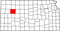 | |
| Townships | ||
| Footnotes | ‡This populated place also has portions in an adjacent county or counties | |