Grade II* listed buildings in South Holland
There are over 20,000 Grade II* listed buildings in England. This page is a list of these buildings in the district of South Holland in Lincolnshire.
South Holland
| Name | Location | Type | Completed [note 1] | Date designated | Grid ref.[note 2] Geo-coordinates |
Entry number [note 3] | Image |
|---|---|---|---|---|---|---|---|
| The Manor House | Crowland, South Holland | House | c. 1775 | 7 February 1967 | TF2398510260 52°40′33″N 0°10′03″W / 52.675867°N 0.167632°W |
1359273 | 
|
| The Peacock Guest House | Donington, South Holland | House | Late 17th century | 13 January 1988 | TF2089035683 52°54′18″N 0°12′14″W / 52.904993°N 0.204001°W |
1064450 |  |
| Wikes Farmhouse | Donington, South Holland | Farmhouse | 1680 | 13 January 1988 | TF2314835407 52°54′07″N 0°10′14″W / 52.902002°N 0.170551°W |
1359286 |
|
| 36 Church Street | Donington, South Holland | House | Mid 18th century | 7 February 1967 | TF2085235905 52°54′25″N 0°12′16″W / 52.906997°N 0.204483°W |
1064448 |
|
| Church of Holy Trinity | Gedney Hill, South Holland | Parish Church | Late 14th century | 30 June 1966 | TF3386811273 52°40′57″N 0°01′16″W / 52.682619°N 0.021138°W |
1146771 | .jpg) |
| Cressy Hall | Gosberton, South Holland | House | 1695 | 7 February 1967 | TF2240430479 52°51′28″N 0°11′00″W / 52.857894°N 0.183457°W |
1064460 |
|
| Garnsgate Hall with Wall and Railings | Lutton, South Holland | House | Early 18th century | 30 June 1966 | TF4191222624 52°46′57″N 0°06′10″E / 52.782546°N 0.102674°E |
1359230 | 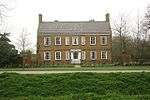 |
| Chapel of St James | Moulton Chapel, Moulton, South Holland | Chapel of Ease | 1722 | 7 February 1967 | TF2934818231 52°44′46″N 0°05′07″W / 52.746231°N 0.085225°W |
1359293 | 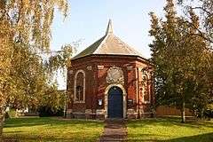 |
| Crosskeys Bridge | River Nene, Sutton Bridge, South Holland | Swing Bridge | 1897 | 11 January 1980 | TF4821721030 52°46′00″N 0°11′43″E / 52.766535°N 0.195364°E |
1064536 | 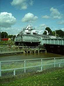 |
| East Lighthouse on Bank of River Nene | Sutton Bridge, South Holland | Lighthouse/House | C20 | 1 April 1980 | TF4931025717 52°48′30″N 0°12′49″E / 52.808336°N 0.213687°E |
1281069 | .jpg) |
| Hydraulic Engine House | Sutton Bridge, South Holland | Hydraulic Engine House | 1897 | 11 January 1980 | TF4800620902 52°45′56″N 0°11′32″E / 52.765443°N 0.192181°E |
1204796 |  |
| West Lighthouse on Bank of River Nene | River Nene, Sutton Bridge, South Holland | House | C20 | 30 June 1966 | TF4911625750 52°48′31″N 0°12′39″E / 52.808686°N 0.210826°E |
1064537 | 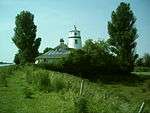 |
| Tower to Church of St James | Sutton St James, South Holland | Tower | 15th century | 26 November 1987 | TF3962518388 52°44′42″N 0°04′01″E / 52.745087°N 0.066986°E |
1204853 | 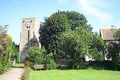 |
| Cley Hall | High St, Spalding, South Holland | Hotel | Mid 18th century | 29 December 1950 | TF2513922840 52°47′19″N 0°08′45″W / 52.788632°N 0.145784°W |
1169039 | .jpg) |
| Constitutional Club | Spalding, South Holland | House | Mid 18th century | 29 December 1950 | TF2486222776 52°47′17″N 0°09′00″W / 52.788121°N 0.149913°W |
1063999 | .jpg) |
| East Elloe | High St., Spalding, South Holland | House | Late 18th century | 29 December 1950 | TF2521422981 52°47′24″N 0°08′41″W / 52.789881°N 0.144618°W |
1359525 |
|
| Garden Wall to No 21, High St | Spalding, South Holland | Garden Wall | 20 November 1975 | TF2510622816 52°47′18″N 0°08′47″W / 52.788424°N 0.146282°W |
1063983 |
| |
| Garden Wall to the South of No 4, Church St | Spalding, South Holland | Gate | 18th century | 20 November 1975 | TF2501122496 52°47′08″N 0°08′52″W / 52.785571°N 0.147812°W |
1147578 |
|
| Monk's House, Bourne Rd | Spalding, South Holland | House | Early 16th century | 29 December 1950 | TF2310022164 52°46′59″N 0°10′35″W / 52.783026°N 0.176257°W |
1063993 |
|
| Old Office Block of Land Settlement Association | Low Fulney, South Holland | House | Medieval | 19 December 1978 | TF2712222352 52°47′02″N 0°07′00″W / 52.783784°N 0.116585°W |
1359567 |
|
| Spalding High School for Girls | Spalding, South Holland | House | Mid 18th century | 29 December 1950 | TF2469822099 52°46′55″N 0°09′09″W / 52.782076°N 0.152601°W |
1306654 |
|
| The Grange, Pinchbeck Rd | Spalding, South Holland | House | Mid 18th century | 29 December 1950 | TF2481422913 52°47′22″N 0°09′02″W / 52.789363°N 0.150572°W |
1063959 |
|
| The Limes | Spalding, South Holland | House | Early 18th century | 29 December 1950 | TF2493822710 52°47′15″N 0°08′56″W / 52.78751°N 0.148812°W |
1063971 |  |
| The Masters Lodge | Spalding, South Holland | House | 1721 | 29 December 1950 | TF2502522544 52°47′10″N 0°08′51″W / 52.785999°N 0.147586°W |
1359534 |
|
| The Sycamores | Spalding, South Holland | House | Early 19th century | 29 December 1950 | TF2494922728 52°47′16″N 0°08′55″W / 52.787669°N 0.148642°W |
1307194 |  |
| The Vicarage | Spalding, South Holland | House | Early 19th century | 29 December 1950 | TF2509022462 52°47′07″N 0°08′48″W / 52.785247°N 0.146654°W |
1064006 |
|
| Vicarage to Church of St Paul | Fulney, South Holland | Vicarage | 1877-1879 | 21 August 2007 | TF2610223817 52°47′50″N 0°07′52″W / 52.797186°N 0.131136°W |
1392209 |
|
| Welland Terrace | Spalding, South Holland | Terraced House | 18th century | 29 December 1950 | TF2481622388 52°47′05″N 0°09′03″W / 52.784645°N 0.150743°W |
1359539 | .jpg) |
| Westbourne House | Spalding, South Holland | House | Mid 18th century | 29 December 1950 | TF2482622129 52°46′56″N 0°09′02″W / 52.782316°N 0.150693°W |
1359518 | .jpg) |
| Westbourne Lodge | Spalding, South Holland | House | Mid 18th century | 29 December 1950 | TF2477822044 52°46′54″N 0°09′05″W / 52.781563°N 0.151437°W |
1359519 |
|
| White Hart Hotel | Spalding, South Holland | Hotel | Mid 18th century | 29 December 1950 | TF2478622670 52°47′14″N 0°09′04″W / 52.787186°N 0.15108°W |
1063953 |  |
| Willesby | Spalding, South Holland | House | Early 17th century | 29 December 1950 | TF2522323195 52°47′30″N 0°08′40″W / 52.791802°N 0.144403°W |
1063991 |
|
| Wisteria Lodge | Spalding, South Holland | House | 1792 | 29 December 1950 | TF2498022529 52°47′09″N 0°08′54″W / 52.785874°N 0.148259°W |
1147529 |  |
| Yew Lodge | Spalding, South Holland | Country House | Mid-Late 18th century | 29 December 1950 | TF2511222810 52°47′18″N 0°08′46″W / 52.788368°N 0.146195°W |
1359524 |
|
| 34 London Road | Spalding, South Holland | House | Early 18th century | 29 December 1950 | TF2477722185 52°46′58″N 0°09′05″W / 52.78283°N 0.151398°W |
1063947 |
|
| 1 Sheep Market | Spalding, South Holland | Smiths Cottage | c. 1230 | 29 December 1950 | TF2464622707 52°47′15″N 0°09′11″W / 52.787551°N 0.153141°W |
1359545 | |
Notes
- ↑ The date given is the date used by Historic England as significant for the initial building or that of an important part in the structure's description.
- ↑ Sometimes known as OSGB36, the grid reference is based on the British national grid reference system used by the Ordnance Survey.
- ↑ The "List Entry Number" is a unique number assigned to each listed building and scheduled monument by Historic England.
External links
![]() Media related to Grade II* listed buildings in Lincolnshire at Wikimedia Commons
Media related to Grade II* listed buildings in Lincolnshire at Wikimedia Commons
This article is issued from Wikipedia - version of the 8/24/2016. The text is available under the Creative Commons Attribution/Share Alike but additional terms may apply for the media files.