Green infrastructure
Green Infrastructure or blue-green infrastructure is a network providing the “ingredients” for solving urban and climatic challenges by building with nature.[1] The main components of this approach include stormwater management, climate adaptation, less heat stress, more biodiversity, food production, better air quality, sustainable energy production, clean water and healthy soils, as well as the more anthropocentric functions such as increased quality of life through recreation and providing shade and shelter in and around towns and cities.[2] Green infrastructure also serves to provide an ecological framework for social, economic and environmental health of the surroundings.[3]
Introduction
Green infrastructure
Nature can be used to provide important services for communities by protecting them against flooding or excessive heat, or helping to improve air, soil and water quality. When nature is harnessed by people and used as an infrastructural system it is called “green infrastructure”.[4] Green infrastructure occurs at all scales. It is most often associated with storm water management systems, which are smart and cost-effective.[5] However, green infrastructure is really a bigger concept and is closely associated with many other things. Green infrastructure also serves to provide an ecological framework for social, economic and environmental health of the surroundings.[6]
Blue infrastructure
"Blue" or Water infrastructure is commonly associated with green infrastructure and referred to as "blue-green" when there is a combination of the two in the design.
Benefits
Some people might expect that green spaces are excessive to maintain and extravagant in nature, but high-performing green spaces can provide real economic, ecological and social benefits.[7] For example:
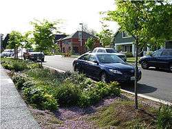
- Urban forestry in an urban environment can supplement managing storm water and reduce the energy usage costs and runoff in result.[5]
- Bio-retention systems can work to create a green transportation system.[5]
In result, high performing green spaces work to create a balance between built and natural environments.[5]
- Higher abundance of green space in communities or neighbourhoods is observed to have higher frequencies in participation of physical activity among elderly men.[8]
- More green space around one's house is associated with better mental health.[9]
Economic effects
A study in 2012 that focused on 479 green infrastructure projects across the United States, found that 44% of green infrastructure projects reduced costs compared to the 31% that increased the costs. The most notable cost savings were due to reduced stormwater runoff and decreased heating and cooling costs.[10][11]
Terminology
Ideas for green urban structures began in the 1870s, with concepts of urban farming and garden allotments.[1] Alternative terminology includes stormwater best management practices (BMPs), source controls, and low impact development (LID) practices.[12]
Green infrastructure concepts originated in mid-1980s proposals for best management practices that would achieve more holistic stormwater quantity management goals for runoff volume reduction, erosion prevention, and aquifer recharge.[13] In 1987, amendments to the U.S. Clean Water Act introduced new provisions for management of diffuse pollutant sources from urban land uses, establishing the regulatory need for practices that unlike conventional drainage infrastructure managed runoff "at source." Under the Act, the U.S. Environmental Protection Agency (EPA) published regulations for municipalities in 1990, requiring the development of storm water pollution prevention plans and the implementation of "source control practices".[14] EPA's 1993 handbook, Urban Runoff Pollution Prevention and Control Planning, identified BMPs to consider in such plans, including vegetative controls, filtration practices and infiltration practices (trenches, porous pavement).[15]
Green Infrastructure is a concept that highlights the importance of the natural environment in decisions about land-use planning.[16][17] However, the term does not have a widely recognised definition.[18][19] Also known as “blue-green infrastructure”[20] or “green-blue urban grids”[1] the terms are used by many design-, conservation- and planning related disciplines and commonly feature stormwater management, climate adaptation and multifunctional green space.
The term "green infrastructure" is sometimes expanded to "multifunctional" green infrastructure. Multifunctionality in this context refers to the integration and interaction of different functions or activities on the same piece of land.
EPA extended the concept of “green infrastructure” to apply to the management of stormwater runoff at the local level through the use of natural systems, or engineered systems that mimic natural systems, to treat polluted runoff.[21] This use of the term "green infrastructure" to refer to urban "green" BMPs, although not central to the larger concept, does contribute to the overall health of natural ecosystems.
However, it is apparent that the term “blue-green infrastructure” is applied in an urban context and places a greater emphasis on the management of stormwater as an integral part of creating a sustainable, multifunctional urban environment.[20]
The role of water
Many cities are facing severe water uncertainties, such as floods, droughts and upstream activities on trans-boundary rivers. The increasing pressure, intensity and speed of urbanisation has led to the disappearance of any visible form of water infrastructure in most cities.[22]
One fifth of the world’s population, 1.2 billion people, live in areas of water scarcity. Climate change and water-related disasters will place increasing demands on urban systems and will result in increased migration to urban areas. Cities require a very large input of freshwater and in turn have a huge impact on freshwater systems. Urban and industrial water use is projected to double by 2050.[23]
In 2010 the United Nations declared that access to clean water and sanitation is a Human Right.[24] New solutions for improving the sustainability of cities are being explored. Good urban water management is complex and requires not only water and wastewater infrastructure, but also pollution control and flood prevention. It requires coordination across many sectors and between different local authorities and changes in governance that lead to more sustainable and equitable use of the urban water resources.[23]
Types of green infrastructure
Urban forests
Urban forests are forests located in cities. They are an important component of urban green infrastructure systems. Urban forests use appropriate tree and vegetation species, instead of noxious and invasive kinds, which reduce the need of maintenance and irrigation.[25] In addition, native species also provide aesthetic value while reducing cost. Diversity of plant species should also be considered in design of urban forests to avoid monocultures; this makes the urban forests more durable and resilient to pests and other harms.[25]
Benefits
- Energy Use: According to a study conducted by the Lawrence Berkeley National Laboratory and Sacramento Municipal Utility District, it was found that urban trees can provide up to 47% energy savings.[25]
- Urban Heat Island: Maximum air temperature for tree groves were found to be lower than that of open areas without trees. This is because of a process called evaporative cooling.[25]
- Water Management: Urban forests helps with city water management on diverting storm water from water channels. Trees intercept a large amount of rainfall that hit them.[25]
- Air Pollution: Trees hold carbon, which improve air quality in cities.[25]
- Property Values: Having more trees increases property value, which suggests that people value greenery and trees wherever they are. This implies that trees contribute to the preferred living conditions of people. Urban greenery can also improve mental health and well-being.[25]
Constructed wetlands
Constructed wetlands are manmade wetlands, which work as a bio-filtration system. They contain wetland vegetation and are mostly built on uplands and floodplains.[26] Constructed wetlands are built this way to avoid connection or damage to natural wetlands and other aquatic resources.[26] There are two main categories of constructed wetlands: subsurface flow system and free water surface system.[26] Proper planning and operating can help avoid possible harm done to the wetlands, which are caused by alteration of natural hydrology and introduction of invasive species.[26]
Benefits
- Water efficiency: Constructed wetlands try to replicate natural wetland ecosystems. They are built to improve water efficiency and water quality. They also create wildlife habitats by using natural processes of plants, soils, and associated microorganisms. In these types of wetlands, vegetation can trap parts of suspended solids and slow down water flow; the microorganisms that live there process some other pollutants.[26]
- Cost-effective: Wetlands have low operating and maintenance costs. They can also help with fluctuating water levels. Aesthetically, constructed wetlands are able to add greenery to its surrounding environment. It also helps to reduce unpleasing odors of wastewater.[26][27]
Green roofs and green walls
Green roofs improve air and water quality while reducing energy cost. The plants and soil provide more green space and insulation on roofs. Green roofs also help reducing city runoff by retaining rainfall.[28]
Planning approach
The Green Infrastructure approach analyses the natural environment in a way that highlights its function and subsequently seeks to put in place, through regulatory or planning policy, mechanisms that safeguard critical natural areas. Where life support functions are found to be lacking, plans may propose how these can be put in place through landscaped and/or engineered improvements.[29]
Within an urban context, this can be applied to re-introducing natural waterways[30] and making a city self-sustaining particularly with regard to water, for example, to harvest water locally, recycle it, re-use it and integrate stormwater management into everyday infrastructure.[31]
The multi-functionality of this approach is key to the efficient and sustainable use of land, especially in a compact and bustling country such as England where pressures on land are particularly acute. An example might be an urban edge river floodplain which provides a repository for flood waters, acts as a nature reserve, provides a recreational green space and could also be productively farmed (probably through grazing). There is growing evidence that the natural environment also has a positive effect on human health.[32]
United Kingdom
In the United Kingdom, Green Infrastructure planning is increasingly recognised as a valuable approach for spatial planning and is now seen in national, regional and local planning and policy documents and strategies, for example in the Milton Keynes and South Midlands Growth area.[33]
In 2009, guidance on green infrastructure planning was published by Natural England, and can be accessed online at This guidance promotes the importance of green infrastructure in 'place-making', i.e. in recognizing and maintaining the character of a particular location, especially where new developments are planned.[34]
In North West England the former Regional Spatial Strategy had a specific Green Infrastructure Policy (EM3 - Green Infrastructure) as well as other references to the concept in other land use development policies (e.g. DP6).[35] The policy was supported by the North West Green Infrastructure Guide.[36] The Green Infrastructure Think Tank (GrITT) provides the support for policy development in the region and manages the web site that acts as a repository for information on Green Infrastructure.[37]
The Natural Economy Northwest programme has supported a number of projects, commissioned by The Mersey Forest to develop the evidence base for green infrastructure in the region. In particular work has been undertaken to look at the economic value of green infrastructure, the linkage between grey and green infrastructure and also to identify areas where green infrastructure may play critical role in helping to overcome issues such as risks of flood or poor air quality.
In March 2011, a prototype Green Infrastructure Valuation Toolkit[38] was launched. The Toolkit is available under a Creative Commons licence, and provides a range of tools that provide economic valuation of green infrastructure interventions. The toolkit has been trialled in a number of areas and strategies, including the Liverpool Green Infrastructure Strategy.[39]
In 2012, the Greater London Authority published the All London Green Grid Supplementary Planning Guidance (ALGG SPG) which proposes an integrated network of green and open spaces together with the Blue Ribbon Network of rivers and waterways. The ALGG SPG aims to promote the concept of green infrastructure, and increase its delivery by boroughs, developers, and communities, to benefit areas such as sustainable travel, flood management, healthy living and the economic and social uplift these support.[40]
Green Infrastructure is being promoted as an effective and efficient response to projected climate change.[41]
Green Infrastructure may include geodiversity objectives.[42]
United States
Green infrastructure programs managed by EPA and partner organizations are intended to improve water quality generally through more extensive management of stormwater runoff. The practices are expected to reduce stress on traditional water drainage infrastructure--storm sewers and combined sewers—which are typically extensive networks of underground pipes and/or surface water channels in U.S. cities, towns and suburban areas. Improved stormwater management is expected to reduce the frequency of combined sewer overflows and sanitary sewer overflows, reduce the impacts of urban flooding, and provide other environmental benefits.[43][44]
For example, the City of Philadelphia has installed or supported a variety of retrofit projects in neighborhoods throughout the city. Installed improvements include:
- permeable pavements in parks, basketball courts and parking lots
- rain gardens and bioretention systems at schools and other public facilities
- constructed wetlands for management of stormwater runoff.
Some of these facilities reduce the volume of runoff entering the city's aging combined sewer system, and thereby reduce the extent of system overflows during rainstorms.[45]
Another U.S. example is the State of Maryland's promotion of a program called GreenPrint. GreenPrint Maryland is the first web-enabled map in the nation that shows the relative ecological importance of every parcel of land in the state.
Combining color-coded maps, information layers, and aerial photography with public openness and transparency, Greenprint Maryland applies the best environmental science and Geographic Information Systems (GIS) to the urgent work of preserving and protecting environmentally critical lands. A valuable new tool not only for making land conservation decisions today, but for building a broader and better informed public consensus for sustainable growth and land preservation decisions into the future.
The program was established in 2001 with the objective to “preserve an extensive, intertwined network of land vital to the long-term survival of our native plants and wildlife and industries dependent on clean environment and abundant natural resources.”[46]
In April 2011, EPA announced the Strategic Agenda to Protect Waters and Build More Livable Communities through Green Infrastructure and the selection of the first ten communities to be green infrastructure partners.[47][48] The communities selected were: Austin, Texas; Chelsea, Massachusetts; the Northeast Ohio Regional Sewer District (Cleveland, Ohio); the City and County of Denver, Colorado; Jacksonville, Florida; Kansas City, Missouri; Los Angeles, California; Puyallup, Washington; Onondaga County and the City of Syracuse, New York; and Washington, D.C.[49]
The Federal Emergency Management Agency (FEMA) is also promoting green infrastructure as a means of managing urban flooding (also known as localized flooding).[50]
Singapore
Since 2009, two editions of the ABC (Active, Beautiful, Clean) Waters Design Guidelines have been published by the Public Utilities Board (PUB), Singapore. The latest version (2011) contains planning and design considerations for the holistic integration of drains, canals and reservoirs with the surrounding environment. PUB encourages the various stakeholders — landowners, private developers to incorporate ABC Waters design features into their developments, and the community to embrace these infrastructures for recreational & educational purposes.
The main benefits outlined in the ABC Waters Concept include:
- Treating stormwater runoff closer to the source naturally, without the use of chemicals through the use of plants and soil media, so that cleaner water is discharged into waterways and eventually our reservoirs.
- Enhancing biodiversity and site aesthetics.
- Bringing people closer to water, and creating new recreational and community spaces for people to enjoy.[51]
Other states
A 2012 paper by the Overseas Development Institute reviewed evidence of the economic impacts of green infrastructure in fragile states.
Upfront construction costs for GI were up to 8% higher than non-green infrastructure projects. Climate Finance was not adequately captured by Fragile states for GI investments, and governance issues may further hinder capability to take full advantage.
GI Investments needed strong government participation as well as institutional capacities and capabilities that fragile states may not possess. Potential poverty reduction includes improved agricultural yields and higher rural electrification rates, benefits that can be transmitted to other sectors of the economy not directly linked to the GI investment.
Whilst there are examples of GI investments creating new jobs in a number of sectors, it is unclear what the employment opportunities advantages are in respect to traditional infrastructure investments. The correct market conditions (i.e. labour regulations or energy demand) are also required in order to maximise employment creation opportunities.
Such factors that may not be fully exploited by fragile state governments lacking the capacity to do so. GI investments have a number of co-benefits including increased energy security and improved health outcomes, whilst a potential reduction of a country’s vulnerability to the negative effects of climate change being arguably the most important co-benefit for such investments in a fragile state context.
There is some evidence that GI options are taken into consideration during project appraisal. Engagement mostly occurs in projects specifically designed with green goals, hence there is no data showing decision making that leads to a shift towards any green alternative. Comparisons of costs, co-benefits, poverty reduction benefits or employment creation benefits between the two typologies are also not evident.[52]
Currently, an international standard for green infrastructure is developed: SuRe® – The Standard for Sustainable and Resilient Infrastructure is a global voluntary standard which integrates key criteria of sustainability and resilience into infrastructure development and upgrade.[3] SuRe® is developed by the Swiss Global Infrastructure Basel Foundation (GIB) and the French bank Natixis as part of a multi-stakeholder process and will be compliant with ISEAL guidelines.[53]
Examples
ABC Water Design Guidelines by PUB in Singapore
Since 2009, two editions of the ABC (Active, Beautiful, Clean) Waters Design Guidelines have been published by the Public Utilities Board (PUB), Singapore. The latest version in 2011 contains planning and design considerations for the holistic integration of drains, canals and reservoirs with the surrounding environment. PUB encourages the various stakeholders — landowners, private developers to incorporate ABC Waters design features into their developments, and the community to embrace these infrastructures for recreational & educational purposes.
The main benefits outlined in the ABC Waters Concept include:
- Treating stormwater runoff closer to the source naturally, without the use of chemicals through the use of plants and soil media, so that cleaner water is discharged into waterways and eventually our reservoirs.
- Enhancing biodiversity and site aesthetics.
- Bringing people closer to water, and creating new recreational and community spaces for people to enjoy.[54]
Stormwater Management, Surrey, British Columbia
Farmers claimed that flooding of their farmlands was caused by suburban development upstream. The flooding was a result of funneled runoff directed into storm drains by impervious cove, which ran unmitigated and unabsorbed into their farmlands downstream. The farmers were awarded an undisclosed amount of money in the tens of millions as compensation. Low density and highly paved residential communities redirect stormwater from impervious surfaces and pipes to stream at velocities much greater than predevelopment rates. Not only are these practices environmentally damaging, they can be costly and inefficient to maintain. In response, the city of Surrey opted to employ a green infrastructure strategy and chose a 250-hectare site called East Clayton as a demonstration project. The approach reduced the stormwater flowing downstream and allows for infiltration of rainwater closer if not at its point of origin. In result, the stormwater system at East Clayton had the ability to hold one inch of rainfall per day, accounting for 90% of the annual rainfall. The incorporation of green infrastructure at Surrey, British Columbia was able to create a sustainable environment that diminishes runoff and to save around $12,000 per household.[4]
Nya Krokslätt, Sweden
The site of former factory “Nya Krokslätt” is situated between a mountain and a stream. Danish engineers, Ramboll, have designed a concept of slowing down and guiding storm water in the area with methods such as vegetation combined with ponds, streams and soak-away pits as well as glazed green-blue climate zones surrounding the buildings which delay and clean roof water and grey water. The design concept provides for a multifunctional, rich urban environment, which includes not only technical solutions for energy efficient buildings, but encompasses the implementation of blue-green infrastructure and ecosystem services in an urban area.[20]
Zürich, Switzerland
Since 1991, the city of Zürich has had a law stating all flat roofs (unless used as terraces) must be greened roofed surfaces. The main advantages as a result of this policy include increased biodiversity, rainwater storage and outflow delay, and micro-climatic compensation (temperature extremes, radiation balance, evaporation and filtration efficiency).[55] Roof biotopes are stepping stones which, together with the earthbound green areas and the seeds distributed by wind and birds, make an important contribution to the urban green infrastructure.[1]
Duisburg-Nord, Germany
In the old industrial area of the Ruhr District in Germany, Duisburg-Nord is a landscape park which incorporates former industrial structures and natural biodiversity. The architects Latz + Partner developed the water park which now consists of the old River Emscher, subdivided into five main sections: Klarwasserkanal (Clear Water Canal), the Emschergraben (Dyke), the Emscherrinne (Channel), the Emscherschlucht (Gorge) and the Emscherbach (Stream). The open waste water canal of the “Old Emscher” river is now fed gradually by rainwater collection through a series of barrages and water shoots. This gradual supply means that, even in lengthy dry spells, water can be supplied to the Old Emscher to replenish the oxygen levels.[56] This has allowed the canalised river bed to become a valley with possibilities for nature development and recreation. As a key part of the ecological objectives, much of the overgrown areas of the property were included in the plan as they were found to contain a wide diversity of flora and fauna, including threatened species from the red list. Another important theme in the development of the plan was to make the water system visible, in order to stimulate a relationship between visitors and the water.[1]
New York Sun Works Center, US
The Greenhouse Project was started in 2008 by a small group of public school parents and educators to facilitate hands-on learning, not only to teach about food and nutrition, but also to help children make educated choices regarding their impact on the environment. The laboratory is typically built as a traditional greenhouse on school rooftops and accommodates a hydroponic urban farm and environmental science laboratory. It includes solar panels, hydroponic growing systems, a rainwater catchment system, a weather station and a vermi composting station. Main topics of education include nutrition, water resource management, efficient land use, climate change, biodiversity, conservation, contamination, pollution, waste management, and sustainable development. Students learn the relationship between humans and the environment and gain a greater appreciation of sustainable development and its direct relationship to cultural diversity.[57]
Hammarby Sjöstad, Stockholm, Sweden
In the early 1990s, Hammarby Sjöstad had a reputation for being a run-down, polluted and unsafe industrial and residential area.[1] Now, it is a new district in Stockholm where the City has imposed tough environmental requirements on buildings, technical installations and the traffic environment. An ‘eco-cycle’ solution named the Hammarby Model, developed by Fortum, Stockholm Water Company and the Stockholm Waste Management Administration, is an integral energy, waste and water system for both housing and offices. The goal is to create a residential environment based on sustainable resource usage.[58] Examples include waste heat from the treated wastewater being used for heating up the water in the district heating system, rainwater runoff is returned to the natural cycle through infiltration in green roofs and treatment pools, sludge from the local wastewater treatment is recycled as fertiliser for farming and forestry.[1] This sustainable model has been a source of inspiration to many urban development projects including the Toronto (Canada) Waterfront, London's New Wembley, and a number of cities/city areas in China.[59]
Emeryville, California, US
EPA supported the city of Emeryville, California in the development of "Stormwater Guidelines for Green, Dense Redevelopment."[60] Emeryville, which is a suburb of San Francisco, began in the 1990s reclaiming, remediating and redeveloping the many brownfields within its borders. These efforts sparked a successful economic rebound. The city did not stop there, and decided in the 2000s to harness the redevelopment progress for even better environmental outcomes, in particular that related to stormwater runoff, by requiring in 2005 the use of on-site GI practices in all new private development projects. The city faced several challenges, including a high water table, tidal flows, clay soils, contaminated soil and water, and few absorbent natural areas among the primarily impervious, paved parcels of existing and redeveloped industrial sites. The guidelines, and an accompanying spreadsheet model, were developed to make as much use of redevelopment sites as possible for handling stormwater. The main strategies fell into several categories:
- Reducing the need, space and stormwater impact of motor vehicle parking by way of increased densities, height limits and floor area ratios; shared, stacked, indoor and unbundled automobile parking; making the best use of on-street parking and pricing strategies; car-sharing; free city-wide mass transit; requiring one secure indoor bicycle parking space per bedroom and better bicycle and pedestrian roadway infrastructure.
- Sustainable landscape design features, such as tree preservation and minimum rootable soil volumes for new tree planting, use of structural soils, suspended paving systems, bioretention and biofiltration strategies and requiring the use of the holistic practices of Bay-Friendly Landscaping.[61]
- Water storage and harvesting through cisterns and rooftop containers.
- Other strategies to handle or infiltrate water on development and redevelopment sites.
Gowanus Canal Sponge Park, New York, US
The Gowanus Canal, in Brooklyn, New York, is bounded by several communities including Park Slope, Cobble Hill, Carroll Gardens, and Red Hook. The canal empties into New York Harbor. Completed in 1869, the canal was once a major transportation route for the then separate cities of Brooklyn and New York City. Manufactured gas plants, mills, tanneries, and chemical plants are among the many facilities that operated along the canal. As a result of years of discharges, storm water runoff, sewer outflows, and industrial pollutants, the canal has become one of the nation's most extensively contaminated water bodies. Contaminants include PCBs, coal tar wastes, heavy metals, and volatile organics. On March 2, 2010, EPA added the canal to the its Superfund National Priorities List (NPL). Placing the canal on the list allows the agency to further investigate contamination at the site and develop an approach to address the contamination.
After the NPL designation, several firms tried to redesign the area surrounding the canal to meet EPA's principles. One of the proposals was the Gowanus Canal Sponge Park, suggested by DLANDstudio, an architecture and landscape architecture firm based in Brooklyn. The firm designed a public open space system that slows, absorbs, and filters surface water runoff with the goal of remediating contaminated water, activating the private canal waterfront, and revitalizing the neighborhood. The unique feature of the park is its character as a working landscape that means the ability to improve the environment of the canal over time while simultaneously supporting public engagement with the canal ecosystem. The park was cited in a professional award by the American Society of Landscape Architects, in the Analysis and Planning category, in 2010.
Lafitte Greenway + Revitalization Corridor | Linking New Orleans Neighborhoods, New Orleans, Louisiana, US
The Lafitte Greenway in New Orleans, Louisiana, is a post-Hurricane Katrina revitalization effort that utilizes green infrastructure to improve water quality as well as support wildlife habitat.[62] The site was previously an industrial corridor that connected the French Quarter to Bayou St. John and Lake Pontchartrain.[62] Part of the revitalization plan was to incorporate green infrastructure for environmental sustainability.[62] One strategy to mitigate localized flooding was to create recreation fields that are carved out to hold water during times of heavy rains.[62] Another strategy was to restore the native ecology of the corridor, giving special attention to the ecotones that bisect the site.[62] The design proposed retrofitting historic buildings with stormwater management techniques, such as rainwater collection systems, which allows historic buildings to be preserved.[62] This project received the Award of Excellence from the American Society of Landscape Architects in 2013.[62]
Geographic Information System applications
A Geographic Information System (GIS) is a computer system for that allows users to capture, store, display, and analyze all kinds of spatial data on Earth.[63] GIS can gather multiple layers of information on one single map regarding streets, buildings, soil types, vegetation, and more.[63] Planners can combine or calculate useful information such as impervious area percentage or vegetation coverage status of a specific region to design or analyze the use of green infrastructure. The continued development of Geographic Information Systems (GIS) and their increasing level of use is particularly important in the development of Green Infrastructure plans. The plans frequently are based on GIS anaysis of many layers of geographic information.[63]
Green Infrastructure Master Plan
According to the Green Infrastructure Master Plan, developed by Hawkins Partners, civil engineers use GIS to analyze the modeling of impervious surfaces with historical Nashville rainfall data within the CSS (combined sewer system) to find the current rates of runoff. GIS are able to help planning teams analyze potential volume reductions at the specific region for green infrastructures, including water harvesting, green roofs, urban trees, and structural control measures.[64]
Implementation
Barriers
Lack of funding is consistently cited as a barrier to the implementation of green infrastructure. One advantage that green infrastructure projects offer, however, is that they generate so many benefits that they can compete for a variety of diverse funding sources. Some tax incentive programs administered by federal agencies can be used to attract financing to green infrastructure projects. Here are two examples of programs whose missions are broad enough to support green infrastructure projects:
- The U.S. Department of Energy administers a range of energy efficiency tax incentives, and green infrastructure could be integrated into project design to claim the incentive. An example of how this might work is found in Oregon’s Energy Efficiency Construction Credits. In Eugene, Oregon, a new biofuel station built on an abandoned gas station site included a green roof, bioswales and rain gardens. In this case, nearly $250,000 worth of tax credits reduced income and sales tax for the private company that built and operated the project.
- The U.S. Department of Treasury administers the multi-billion dollar New Markets Tax Credit program, which encourages private investment for a range of project types (typically real estate or business development projects) in distressed areas. Awards are allocated to non-profit and private entities based on their proposals for distributing these tax benefits.[65]
Benefits

Some people might expect that green spaces are excessive to maintain and extravagant in nature, but high-performing green spaces can provide real economic, ecological and social benefits. For example:
- Urban forestry in an urban environment can supplement managing storm water and reduce the energy usage costs and runoff in result.
- Bio-retention systems can work to create a green transportation system.
- Stormwater Curb Extensions can increase pedestrian safety by increasing visibility and reducing crossing distances at intersections.
In result, high performing green spaces work to create a balance between built and natural environments.
Economic effects
A study in 2012 that focused on 479 green infrastructure projects across the United States, found that 44% of green infrastructure projects reduce costs compared to the 31% that increased the costs. The most notable cost savings were due to reduced stormwater runoff and decreased heating and cooling costs.
A comprehensive green infrastructure in Philadelphia is planned to cost just $1.2 billion over the next 25 years, compared to over $6 billion for "grey" infrastructure (concrete tunnels created to move water). Under the new green infrastructure plan it is expected that:
- 250 people will be employed annually in green jobs.
- Up to 1.5 billion pounds of carbon dioxide emission to be avoided or absorbed through green infrastructure each year (the equivalent of removing close to 3,400 vehicles from roadways)
- Air quality will improve due to all the new trees, green roofs, and parks
- Communities will benefit on the social and health side
- About 20 deaths due to asthma will be avoided
- 250 fewer work or school days will be missed
- Deaths due to excessive urban heat could also be cut by 250 over 20 years.
- The new greenery will increase property values by $390 million over 45 years, also boosting the property taxes the city takes in.
A green infrastructure plan in New York City is expected to cost $1.5 billion less than a comparable grey infrastructure approach. Also, the green stormwater management systems alone will save $1 billion, at a cost of about $0.15 less per gallon. The sustainability benefits in New York City range from $139–418 million over the 20 year life of the project. This green plan estimates that “every fully vegetated acre of green infrastructure would provide total annual benefits of $8.522 in reduced energy demand, $166 in reduced CO2 emissions, $1,044 in improved air quality, and $4,725 in increased property value.”[10][11][66][67]
See also
- Landscape Architecture
- European green infrastructure
- Green belt
- Permaculture
- Infrastructure
- Recycling infrastructure
- Sustainable architecture
- Sustainable engineering
- Sustainable drainage system
- Watershed Central
References
- 1 2 3 4 5 6 7 Hiltrud Pötz & Pierre Bleuze (2012). Urban green-blue grids for sustainable and dynamic cities. Delft: Coop for life. ISBN 978-90-818804-0-4.
- ↑ "Sustainable trade infrastructure in Africa: A key element for growth and prosperity?". International Centre for Trade and Sustainable Development.
- 1 2 "Nachhaltigesinvestment 2016".
- 1 2 Benedict, Mark A. & McMahon, Edward T. (2006). Green Infrastructure: linking landscapes and communities
- 1 2 3 4 "The Value of Green Infrastructure: A Guide to Recognizing Its Economic, Environmental and Social Benefits" (PDF). Chicago, IL: Center for Neighborhood Technology. 21 January 2011.
- ↑ Sprawlwatch Clearinghouse. http://www.sprawlwatch.org/greeninfrastructure.pdf
- ↑ "Sustainable Infrastructure and Finance - UNEP Inquiry".
- ↑ Gong, Y., Gallacher, J., Palmer, S. Fone, D.(2014)Neighbourhood green space, physical function and participation in physical activities among elderly men: the Caerphilly Prospective study The international journal of behavioral nutrition and physical activity 11(1):40.
- ↑ Bos, E.H.; van der Meulen, L.; Wichers, M.; Jeronimus, B.F. (2016). "A Primrose Path? Moderating Effects of Age and Gender in the Association between Green Space and Mental Health". International Journal of Environmental Research and Public Health. 13 (5): 492. doi:10.3390/ijerph13050492.
- 1 2 "Green Infrastructure Could Save Cities Billions".
- 1 2 "The Economics of Green Infrastructure". Washington, D.C.: U.S. Environmental Protection Agency (EPA). 2015-11-02.
- ↑ "Urban Runoff: Low Impact Development". EPA. 2016-01-22.
- ↑ Schueler, Tom (1987). Controlling Urban Runoff: A Practical Manual For Planning And Designing Urban BMPs (Report). Washington, D.C.: Metropolitan Washington Council of Governments.
- ↑ EPA (1990-11-16). "National Pollutant Discharge Elimination System Permit Application Regulations for Storm Water Discharges". Federal Register, 44 FR 47990.
- ↑ Handbook: Urban Runoff Pollution Prevention and Control Planning (Report). Cincinnati: EPA. September 1993. EPA/625/R-93/004.
- ↑ The Conservation Fund, Arlington, VA. "Green Infrastructure." Accessed 2009-10-06.
- ↑ Maryland Department of Natural Resources, Annapolis, MD. Maryland's Green Infrastructure Assessment: A Comprehensive Strategy for Land Conservation and Restoration. May 2003.
- ↑ http://www.eea.europa.eu/publications/green-infrastructure-and-territorial-cohesion accessed: 09.04.13
- ↑ http://www.csc.noaa.gov/magazine/2009/03/article2.html accessed: 09.04.13
- 1 2 3 http://www.ramboll.com/projects/viewproject?projectid=F73AC734-B657-48A0-AE92-0C8A85C8992A accessed: 10.04.13
- ↑ "Basics: What is Green Infrastructure?". EPA. 2016-08-12.
- ↑ http://www.academia.edu/2369268/Water_purificative_landscapes_constructed_ecologies_and_contemporary_urbanism accessed: 10.04.13
- 1 2 http://www.un.org/waterforlifedecade/swm_cities_zaragoza_2010/pdf/02_water_uncertainties.pdf. accessed: 09.04.13
- ↑ "The Human Right to Water (poster)" (PDF). UN-Water Decade Programme on Advocacy and Communication. United Nations. 2011.
- 1 2 3 4 5 6 7 "Green Infrastructure: Cities". American Society of Landscape Architects. Washington, D.C. Retrieved 12 November 2014.
- 1 2 3 4 5 6 "Constructed treatment wetland" (PDF). Retrieved 2 December 2014.
- ↑ "Constructed Wetland". Architecture 2030. Retrieved 7 October 2014.
- ↑ "Green roof". Architecture 2030. Retrieved 7 October 2014.
- ↑ Mark Benedict and Edward T. McMahon (2006). Green Infrastructure, Linking Landscapes and Communities. Washington, D.C.: Island Press. ISBN 1-55963-558-4.
- ↑ http://www.ramboll.com/megatrend/feature-articles/in-the-cities-of-the-future-water-flows-everywhere accessed 11.04.13
- ↑ “Blue-Green Infrastructures”. (December 13, 2012). Topos, p.18, 21,22.
- ↑ Irvine KN, Warber SL. (2002). "Greening healthcare: practicing as if the natural environment really mattered." Altern Ther Health Med. 2002 Sep-Oct;8(5):76-83.
- ↑ "Environment Agency, Bristol, UK".
- ↑ Natural England website 2009
- ↑ North West Regional Assembly, Wigan, UK. "The North West Plan: Submitted Draft Regional Spatial Strategy for the North West of England." January 2006.
- ↑ Green Infrastructure Think Tank (GrITT), Warrington, UK. "North West Green Infrastructure Guide." September 2007.
- ↑ GrITT. "Green Infrastructure North West." Accessed 2009-10-06.
- ↑ Green Infrastructure Valuation Toolkit - www.ginw.co.uk/projects
- ↑ Liverpool Green Infrastructure Strategy 2010. www.ginw.co.uk/liverpool
- ↑ http://www.london.gov.uk/priorities/planning/publications/all-london-green-grid-spg accessed 11.04.13
- ↑ Green Infrastructure to Combat Climate Change - www.ginw.co.uk/climatechange
- ↑ Green Infrastructure Planning in the Black Country: Barrow Hill LNR and Russells Hall Hospital, Dudley - http://www.bcll.org.uk/whats_happening/documents/GreenInfrastructurePlanningintheBCBarrowHillCaseStudy.pdf
- ↑ "Benefits of Green Infrastructure". EPA. 2016-04-19.
- ↑ American Rivers, Inc., Washington, D.C.; Center for Neighborhood Technology, Chicago, IL (2010). "The Value of Green Infrastructure."
- ↑ Philadelphia Water Department. "Green Stormwater Infrastructure." Accessed 2010-04-27.
- ↑ State of Maryland, 2001. “Maryland GreenPrint FAQ’s.” Accessed 2011-01-31.
- ↑ "Managing Wet Weather with Green Infrastructure". EPA. 2011. Archived from the original on 2011-05-17.
- ↑ "A Strategic Agenda to Protect Waters and Build More Livable Communities Through Green Infrastructure" (PDF). Green Infrastructure. EPA. April 2011.
- ↑ "Green Infrastructure Community Partner Organizations" (PDF). Green Infrastructure. EPA. April 2011.
- ↑ "Reducing Damage from Localized Flooding." U.S. Federal Emergency Management Agency, 2005.
- ↑ http://www.pub.gov.sg/abcwaters/abcwatersdesignguidelines/Pages/ABCDesignGuidelines.aspx accessed 11.04.13
- ↑ Lemma, A. Green Infrastructure in Fragile States, October 2012, Overseas Development Institute http://partnerplatform.org/?5amvj9gc
- ↑ "SuRe® - The Standard for Sustainable and Resilient Infrastructure - Global Infrastructure Basel".
- ↑ http://www.pub.gov.sg/abcwaters/abcwatersdesignguidelines/Pages/ABCDesignGuidelines.aspx
- ↑ "Dachbegrünung - Stadt Zürich".
- ↑ http://en.landschaftspark.de/architecture-nature/water-concept accessed: 12.04.13
- ↑ http://nysunworks.org/thegreenhouseproject accessed: 12.04.13
- ↑ http://www.hammarbysjostad.se/ accessed: 15.04.13
- ↑ http://www.cleanenergyawards.com/no_cache/top-navigation/nominees-projects/nominee-detail/singleprintview/project/66/ accessed: 15.04.13
- ↑ http://www.epa.gov/smartgrowth/emeryville.htm
- ↑ "ReScape - Rethinking California Landscapes".
- 1 2 3 4 5 6 7 "2013 ASLA Professional Awards". ASLA.com.
- 1 2 3 "GIS (geographic information system)". National Geographic. Retrieved 4 November 2014.
- ↑ "ASLA 2013 Professional Awards, Green Infrastructure Master Plan".
- ↑ "Funding Opportunities". Green Infrastructure. EPA. 2015-11-02.
- ↑ "Green Infrastructure: Cities". American Society of Landscape Architects.
- ↑ "Green Infrastructure Cost-Benefit Resources". EPA. 2016-08-12.
Further reading
- "Green Infrastructure Design and Implementation". EPA. 2016-02-23.. Design manuals published by state and local agencies.
- Natural Resources Defense Council (2011). Rooftops to Rivers II: Green Strategies for Controlling Stormwater and Combined Sewer Overflows
- City of Philadelphia (2009). "Green City Clean Waters"
- City of Nashville & Davidson County (2009). "Green Infrastructure Design"
- City of Chicago (2010). "Green Alley Handbook"
- Southeast Tennessee Development District (2011). "Green Infrastructure Handbook"
- Center for Green Infrastructure Design (2011). "Why is Green Infrastructure Important ?"
- Center for Green Infrastructure Design (2011). "The Benefits of Green Infrastructure"
External links
- PaveShare - Permeable Paver Design
- Green Infrastructure Case Studies The Conservation Fund
- Save the Rain - Onondaga County, NY
- Maryland's Green Infrastructure- Maryland Department of Natural Resources
- Sonoran Desert Conservation Plan - Pima County, Arizona
- The Center for Green Infrastructure Design - The Center for Green Infrastructure Design
- Green Infrastructure Wiki
- Low Impact Development - The Low Impact Development Center
- Green Infrastructure Resource Center - American Society of Landscape Architects
- Gowanus Sponge Park - ASLA award winner project
- Global Infrastructure Basel Foundation (GIB)