Gudivada
| Gudivada గుడివాడ | |
|---|---|
| City | |
 Gudivada Location in Andhra Pradesh, India | |
| Coordinates: 16°26′N 80°59′E / 16.43°N 80.99°ECoordinates: 16°26′N 80°59′E / 16.43°N 80.99°E | |
| Country | India |
| State | Andhra Pradesh |
| District | Krishna |
| District | Gudivada |
| Area[1] | |
| • Total | 12.67 km2 (4.89 sq mi) |
| Population (2011)[2] | |
| • Total | 118,167 |
| • Density | 9,300/km2 (24,000/sq mi) |
| Languages | |
| • Official | Telugu |
| Time zone | IST (UTC+5:30) |
| PIN | 521301 |
| Telephone code | 91-08674 |
| Vehicle registration | AP-16 |
| Website |
gudivada |
Gudivada is a city in Krishna district of the Indian state of Andhra Pradesh. It is a municipality and the headquarters of Gudivada mandal in Gudivada revenue division.[2][3] It is one of the cities in the state to be a part of Andhra Pradesh Capital Region.[4] It is Twenty sixth most populous city in the state with a population of 118,167.
History
.JPG)
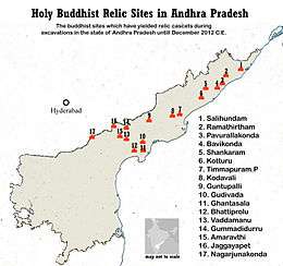
The name Gudivada was derived from Gudi meaning Temple and Vada means Settlement or town in Telugu language. The presence of Habitation at this town may be dated back to 3rd Century BCE or 2nd Century BCE since the time of Sathavahanas as per some inscriptions.[6] Archaeological excavations[7] conducted at Gudivada yielded an ancient Buddhist Stupa Mound and Jain relics. Gudivada is religiously diversified small town with many Hindu Temples and important Jain Tirth[8] of Bhagawan Parshvanath located at market road.
Geography
It is located in the Coastal Andhra region of the state. Gudivada is located 41 kilometres (25.5 mi) east of the district headquarters, Machilipatnam, and 45 kilometres (36.7 mi) south of by road to Amaravati (state capital)[9] It lies on the Eastern coastal plains. The city is located in zone 3 as per Earthquake zones of India.
Climate
Gudivada falls in the hot humid region of the country and it is less than 35 miles from Bay of Bengal. The climate of the town is very hot and it is pleasant during the winter. The hottest day falls in the month of May with shift to June during some years. The maximum temperature observed is 55 C and the minimum temperature observed is 09.80C.
Demographics
As of 2011 census of India, Gudivada had a population of 118,167 with 30,834 households. The total population constitute 59,062 males, 59,105 females and 10,509 in the age group of 0–6 years. It had an average literacy rate of 81.64% with 87,887 literates, significantly higher than the district average of 73.7% and the state average of 67.41%.[2][10]
Government and politics
Civic administration
Gudivada municipality was constituted in the year 1937 as a 'third grade municipality.[11] It was upgraded to special grade municipality and is spread over an area of 12.67 km2 (4.89 sq mi) with 36 election wards.[1] YSR Congress Party won the Gudivada municipal elections in 2014 and the present chairman of the municipality is Yalavarthi Srinivas.[12] The present municipal commissioner is M.Seshagiri.[13]
Transport
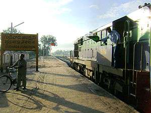
Bus and rail are the major modes of public transport. APSRTC operates buses from Gudivada bus station, which is equipped with a bus depot for storage and maintenance of buses.[14] The city has a total road length of 115.00 km (71.46 mi).[15] The national and state highways that pass through the city include, NH 165–connecting Kathipudi and Pamarru;[16] Gudivada is one of the fourteen B–category stations in the Vijayawada railway division of South Central Railway zone.[17]
Education
The primary and secondary school education is imparted by government, aided and private schools, under the School Education Department of the state.[18][19] The medium of instruction followed by different schools are English, Telugu.
The private aided colleges are, ANR college and KT Reddy women's college. There are eleven other unaided private colleges for undergraduate and postgraduate education.[20] One-forth of the passed out school children will enroll for college education.[21] There are colleges for vocational courses such as, Gudivada Vocational Junior College and St.Johns Vocational Junior College;[22] industrial training centres inlclude, Gudivada Industrial Training Centre, Government Industrial Training Institute for Girls.[23] It is home for Regional Research Institute for Homeopathy.[24][25]
Sports
NTR Stadium in the city was built in partnership with Sports Authority of Andhra Pradesh, the Sports Authority of India and the Gudivada Municipality. It is the multi-purpose stadium for several sports like, athletics, volleyball, cricket, kho kho, kabaddi, badminton, tennikoit and basketball.[26] In January 2016, the stadium hosted the National Rural Sports and Games competition, under the Rajiv Gandhi Khel Abhiyan.[27]
See also
References
- 1 2
- 1 2 3 "District Census Handbook – Krishna" (PDF). Census of India. pp. 16–17, 48. Retrieved 18 January 2015.
- ↑ "Krishna District Mandals" (PDF). Census of India. pp. 504, 528–529. Retrieved 17 July 2015.
- ↑ "Declaration of A.P. Capital Region" (PDF). Andhra Nation. Municipal Administration and Urban Development Department. 22 September 2015. Retrieved 23 September 2015.
- ↑ British Museum Collection
- ↑ Spectrum, Digital (2008-06-05). "Gudivada: Gudivada History". Livegudivada.blogspot.in. Retrieved 2013-05-01.
- ↑ "Archaeological Survey of India". Asihyd.ap.nic.in. Retrieved 2013-05-01.
- ↑ "Shri Gudivada Tirth – Jain Temples in Rest of India". www.Jinalaya.com. Retrieved 2013-05-01.
- ↑ "Gudivada Municipality".
- ↑ "Literacy of AP (Census 2011)" (PDF). Official Portal of Andhra Pradesh Government. p. 43. Retrieved 5 September 2014.
- ↑ "About Us | Gudivada Municipality". gudivada.cdma.ap.gov.in. Retrieved 5 November 2016.
- ↑ "YSR Congress Claims Three Civic Chief Posts in Krishna". The New Indian Express. Machilipatnam. 4 July 2014. Retrieved 28 March 2016.
- ↑ "Contact Details of Commissioners and Mayors of Amrut Cities" (PDF). Atal Mission for Rejuvenation and Urban Transformation. Government of India. Retrieved 28 March 2016.
- ↑ "Depot Name". APSRTC.
- ↑ "Gudivada road length". Municipal Administration and Urban Development Department.
- ↑ "Rationalisation of Numbering Systems of National Highways" (PDF). New Delhi: Department of Road Transport and Highways. Retrieved 3 April 2012.
- ↑ "Divisional info" (PDF). Indian Railways. Retrieved 18 July 2015.
- ↑ "School Eduvation Department" (PDF). School Education Department, Government of Andhra Pradesh. Retrieved 7 November 2016.
- ↑ "The Department of School Education - Official AP State Government Portal | AP State Portal". www.ap.gov.in. Retrieved 7 November 2016.
- ↑ "List of colleges in Krishna district" (PDF). Board of Intermediate Education. Retrieved 27 September 2016.
- ↑ "Gudivada Education".
- ↑ "List of colleges offering vocational courses in Guntur district" (PDF). Sakshi Education. Retrieved 5 October 2016.
- ↑ "Government ITI" (PDF). Sakshi Education. Retrieved 5 October 2016.
- ↑ "REGIONAL RESEARCH INSTITUTE".
- ↑ "Pilot project on 'Integration of Homoeopathy/Yoga' launched in Andhra Pradesh".
- ↑ "NTR Stadium all set to become more sporty". The Hindu. Retrieved 11 April 2016.
- ↑ "National Rural Sports and Games off to a colourful start". The Hindu. Gudivada. 10 January 2016. Retrieved 18 January 2016.
External links
| Wikimedia Commons has media related to Gudivada. |