Gulmi District
| Gulmi Jilla | |
|---|---|
| District | |
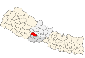 Location of Gulmi | |
| Country | Nepal |
| Region | Western (Pashchimanchal) |
| Zone | Lumbini |
| Headquarters | Tamghas |
| No. of VDC/s | 79 |
| Area | |
| • Total | 1,149 km2 (444 sq mi) |
| Population (2011) | |
| • Total | 280,160 |
| • Density | 240/km2 (630/sq mi) |
| Time zone | NPT (UTC+5:45) |
| Main language(s) | Nepali |
Gulmi District (Nepali: गुल्मी जिल्ला![]() Listen ), a part of Province No. 5, is one of the seventy-five districts of Nepal. The district, with Tamghas as its headquarters, covers an area of 1,149 km², had a population of 296,654 in 2001, 280,160 in 2011 and 268,597 in 2016.[1]
Listen ), a part of Province No. 5, is one of the seventy-five districts of Nepal. The district, with Tamghas as its headquarters, covers an area of 1,149 km², had a population of 296,654 in 2001, 280,160 in 2011 and 268,597 in 2016.[1]
Introduction
It is renowned for coffee farming. Ruru, a Holy Place now also known as Ridi is a market center,where many of the temples are situated. Maghe Sankranti and other festivals are celebrated here. Many local as well as foreign tourists come here to visit the place. Dhurkot's Bichitra Cave, Holy Place Resunga with its rich biodiversity & its historic value, Gyawa Kshetra (Religious & Historical importance place i.e. Ruru Dham, Shringeshwar Tapobhumi , Chhatradevi Mandir-Choyga, Top mountain in this area with historical value is Bauwa & so on), Purtight are some of the attractions of Gulmi. It is believed that first coffee was planted in Anpchaur village of this district.Charpala is also one of the popoluar place in this place. The headquarters of Gulmi, Tamghas, is a small town and the only municipality of Gulmi, situated at the bottom of two hills Resunga and Arjun. It is a place that has been considered sovereign.
Gulmi is rich with naturally beautiful views, natural resources that favour high possibility of tourism.
Communications
There are total of 76 post offices in the district including 1 main district post office,14 ilaka office and 61 others. Number of telecenters have reached 9,[2] FM radios 6, cable TV network 8. According to Nepal Telecom, there are 82,318 GSM mobile subscribers in the district as of 2015. www.gulminews.com is Gulmi's 1st and no. 1 online media that features all the news, articles and information related to Gulmi and Gulmeli. This site has been online since July 2007. Gulmi has 6 FM Radio stations and 1 Radio Nepal FM rely station:
| Radio Station Name | Radio Frequency |
|---|---|
| Radio Resunga | 106.2 MHz |
| Ruru FM | 94.8 MHz |
| Radio Gulmi | 91.2 MHz |
| Radio Sky | 88.4 MHz |
| Radio Nepal | 100.00 MHz |
| Puspanjali Fm | 97.4 MHz |
| Pahilo Radio Baletaksar | 97.8...MHz |
Geography and Climate
| Climate Zone[3] | Elevation Range | % of Area |
|---|---|---|
| Upper Tropical | 300 to 1,000 meters 1,000 to 3,300 ft. |
23.5% |
| Subtropical | 1,000 to 2,000 meters 3,300 to 6,600 ft. |
71.9% |
| Temperate | 2,000 to 3,000 meters 6,400 to 9,800 ft. |
4.6% |
References
- ↑ "National Population and Housing Census 2011(National Report)" (PDF). Central Bureau of Statistics. Government of Nepal. November 2012. Retrieved November 2012. Check date values in:
|access-date=(help) - ↑ "Telecenters in Nepal". TechSansar. Retrieved October 18, 2015.
- ↑ The Map of Potential Vegetation of Nepal - a forestry/agroecological/biodiversity classification system (PDF), . Forest & Landscape Development and Environment Series 2-2005 and CFC-TIS Document Series No.110., 2005, ISBN 87-7903-210-9, retrieved Nov 22, 2013

Coordinates: 28°4′N 83°15′E / 28.067°N 83.250°E
| Wikimedia Commons has media related to Gulmi District. |