Dadeldhura District
| Dadeldhura डडेलधुरा | |
|---|---|
| District | |
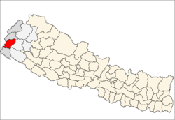 Location of Dadeldhura | |
| Country | Nepal |
| Region | Far-Western (Sudur Pashchimanchal) |
| Zone | Mahakali |
| Headquarters | Dadeldhura |
| Area | |
| • Total | 1,538 km2 (594 sq mi) |
| Population (2011) | |
| • Total | 142,094[1] |
| Time zone | NPT (UTC+5:45) |
| Main language(s) | Dotiyali |
Dadeldhura district (Nepali: डडेलधुरा जिल्ला![]() Listen ), a part of Province No. 7, is one of the seventy-five districts of Nepal. The district, with Dadeldhura as its district headquarters, covers an area of 1,538 km² and had a population of 126,162 in 2001[2] and 142,094 in 2011.[1]
Listen ), a part of Province No. 7, is one of the seventy-five districts of Nepal. The district, with Dadeldhura as its district headquarters, covers an area of 1,538 km² and had a population of 126,162 in 2001[2] and 142,094 in 2011.[1]
The region has a desert-mountainous landscape that contains many religious temples. The district is frequently visited by tourists but contains local routes to Mt Kailaish in Tibet, Ra Ra Lake in Humla district and the last remaining remnants of the Far Western Malla Kingdom. Nagi Malla was the last royal to live here before Nepalese unification.
The spoken language is Doteli and the majority of inhabitants are Hindu. The district is not so rural and is modernizing rapidly. Dadeldhura is the most developed district among other hilly districts in far Western region. It is the most important hub for all the hilly areas l. Dadeldhura is a only way to go up to other upper districts.
Geography and Climate
| Climate Zone[3] | Elevation Range | % of Area |
|---|---|---|
| Lower Tropical | below 300 meters (1,000 ft) | 0.6% |
| Upper Tropical | 300 to 1,000 meters 1,000 to 3,300 ft. |
34.7% |
| Subtropical | 1,000 to 2,000 meters 3,300 to 6,600 ft. |
55.8% |
| Temperate | 2,000 to 3,000 meters 6,400 to 9,800 ft. |
8.9% |
Village Development Committees (VDC/s)
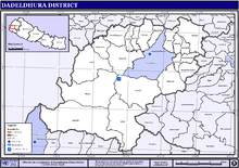 Map of the VDCs in Dadeldhura District |
See also
References
- 1 2 "National Population and Housing Census 2011(National Report)" (PDF). Central Bureau of Statistics. Government of Nepal. November 2012. Retrieved November 2012. Check date values in:
|access-date=(help) - ↑ "Nepal Census 2001". Nepal's Village Development Committees. Digital Himalaya. Retrieved 12 December 2008.
- ↑ The Map of Potential Vegetation of Nepal - a forestry/agroecological/biodiversity classification system (PDF), Forest & Landscape Development and Environment Series 2-2005 and CFC-TIS Document Series No. 110., 2005, ISBN 87-7903-210-9, retrieved Nov 22, 2013
- "Districts of Nepal". Statoids.

Coordinates: 29°18′0″N 80°35′0″E / 29.30000°N 80.58333°E
| Wikimedia Commons has media related to Dadeldhura District. |