Kavrepalanchok District
| Kavrepalanchok काभ्रेपलाञ्चोक जिल्ला | |
|---|---|
| District | |
|
Kavrepalanchok District | |
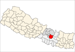 | |
| Country | Nepal |
| Region | Central (Madhyamanchal) |
| Zone | Bagmati |
| Headquarters | Dhulikhel |
| Area | |
| • Total | 1,396 km2 (539 sq mi) |
| Population (2011) | |
| • Total | 381,937 |
| • Density | 270/km2 (710/sq mi) |
| Time zone | NPT (UTC+5:45) |
Kavrepalanchok District (Nepali: काभ्रेपलाञ्चोक जिल्ला![]() Listen Kābhrēpalāñcōk Jillā), (English spelling also: Kavrepalanchowk or Kabhrepalanchok) a part of Province No. 3, is one of the seventy-five districts of Nepal, a landlocked country of South Asia. The district, with Dhulikhel as its district headquarters, covers an area of 1,396 km2 and has a population (2011) of 381,937.
Listen Kābhrēpalāñcōk Jillā), (English spelling also: Kavrepalanchowk or Kabhrepalanchok) a part of Province No. 3, is one of the seventy-five districts of Nepal, a landlocked country of South Asia. The district, with Dhulikhel as its district headquarters, covers an area of 1,396 km2 and has a population (2011) of 381,937.
Geography and climate
| Climate Zone[1] | Elevation Range | % of Area |
|---|---|---|
| Lower Tropical | below 300 meters (1,000 ft) | 0.1% |
| Upper Tropical | 300 to 1,000 meters 1,000 to 3,300 ft. |
23.6% |
| Subtropical | 1,000 to 2,000 meters 3,300 to 6,600 ft. |
65.3% |
| Temperate | 2,000 to 3,000 meters 6,400 to 9,800 ft. |
9.6% |
Health Care
The small health centers in many VDCs are without Auxiliary Health Workers (AHWs), Auxiliary Nurse Midwives (ANMs) and Community Health Workers (CHWs). So, people seeking emergency health assistance have to travel a long distance to the district headquarters or Kathmandu or end up dying because of lack of treatment. Many people still believe in Dhami and Jhakri and don't always seek medicine or go to the hospital for the treatment.
An NGO, PHASE Nepal provides many health care facilities and training programs to Ryale, a VDC of Kavrepalanchok District. Currently PHASE Nepal is working on several projects in this district including community health and education, livelihood, hygiene and sanitation programmes.[2]
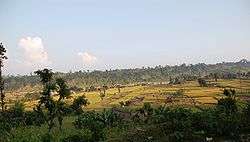
Tourism
Kavre district has great potential in tourism industry. Kavre district is culturally rich with historical places like Dhulikhel, Panauti and Banepa. Big religious fairs like Chandeshwari Jatra of Banepa, Namobuddha Jatra of Namobuddha celebrated on the birth date of Lord Buddha (Buddha Purnima), Kumbha mela of Panauti which happens once in 12 years, are some interesting events to view. Kavre district has great potential in raising its local economy with tourism. Kavre has same potential as that of other tourist sites of Nepal like Pokhara and Jomsom.
The Long Himalayan Gaurishankar range can be seen from Dhulikhel. Kavre is famous for short circuit trekking in places like Dhungkharka-Narayanthan, Dhulikhel-Kavre-Namobuddha-Sankhu-Panauti-Banepa. Some places to visit here in Kavrepalanchok districts are: Palancok Bhagwati, Namobuddha, Dhulikhel, Gaukhureshwar, Hajar Sidhi (1000 Steps to Kali Devi Temple), Devisthan (where Kali Devi Temple is situated), Talu Dada View Tower, Gosainthan, Banepa, Kgopasi, Pasthali, Balthali, Ladkeshwar Mahadev, Nepalthok, Patlekhet, Phulbari.
Kavre can be a good location for those who want to cycle. Cycling is possible in all of the tourist sites mentioned above.
Education
Secondary level
There are many private and governmental schools providing education to the secondary level.
Private schools include Baylor, Vidya Sagar, Sarswati shiksha, Golden future, Siddhart Banasthali, Malpi. Governmental school include Azad, Kavre, Sarbamangala.
Higher secondary And Bachelor level
Nist Education is an education institute in Kavre which offers +2 and Bsc in science for first time in the district. Gyankunj, Siddharth, Balbatika, Indrashower etc. are running +2 and BBS, BEd courses.
University
Kathmandu University[3] is the third oldest university in Nepal. Its popularity is increasing.
References
- ↑ The Map of Potential Vegetation of Nepal – a forestry/agroecological/biodiversity classification system (PDF), . Forest & Landscape Development and Environment Series 2-2005 and CFC-TIS Document Series No.110., 2005, ISBN 87-7903-210-9, retrieved November 22, 2013
- ↑ "Project Area: Kavrepalanchok". PHASE Nepal.
- ↑ http://www.ku.edu.np/kusl/
External links
- Neppol Megasite
- "Districts of Nepal". Statoids.
| Wikimedia Commons has media related to Kavrepalanchok District. |

Coordinates: 27°37′N 85°33′E / 27.617°N 85.550°E