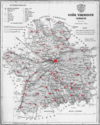
Győr County
| Győr County Comitatus Jauriensis Győr vármegye Komitat Raab | |||||
| County of the Kingdom of Hungary | |||||
| |||||
|
Coat of arms | |||||
 | |||||
| Capital | Győr 47°41′N 17°38′E / 47.683°N 17.633°ECoordinates: 47°41′N 17°38′E / 47.683°N 17.633°E | ||||
| History | |||||
| • | Established | 1598 | |||
| • | Treaty of Trianon | 4 June 1920 | |||
| Area | |||||
| • | 1910 | 1,534 km2 (592 sq mi) | |||
| Population | |||||
| • | 1910 | 136,300 | |||
| Density | 88.9 /km2 (230.1 /sq mi) | ||||
| Today part of | Slovakia, Hungary | ||||

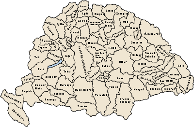
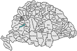
Győr county (in Hungarian: Győr (vár)megye) was an administrative county (comitatus) of the Kingdom of Hungary, it's territory covered present-day north-western Hungary (95%) and south-western Slovakia (about 5%), mostly on the right (south) side of the Danube river. The capital of the county was the city of Győr.
Geography
Győr county shared borders with the counties Moson, Pozsony, Komárom, Veszprém and Sopron. The rivers Danube, and Rába run through the county. Its area was 1534 km² around 1910.
History
The Győr comitatus arose as one of the first comitatus of the Kingdom of Hungary. It was conquered by the Turks in 1541, and again by Habsburg Kingdom of Hungary around 1598.
In 1920 the Treaty of Trianon assigned a very small part of the territory of the county to Czechoslovakia. The rest stayed in Hungary and merged with the eastern part of Moson county and a very small part of Pozsony county to form Győr-Moson-Pozsony county.
After World War II, Győr-Moson-Pozsony county merged with Sopron county to form Győr-Sopron county. This county was renamed to Győr-Moson-Sopron county in the early 1990s. The part of the county north of the river Danube is now in Slovakia, Trnava Region.
Demographics
1900
In 1900, the county had a population of 126,188 people and was composed of the following linguistic communities:[1]
Total:
- Hungarian: 122,925 (97.4%)
- German: 2,465 (2.0%)
- Slovak: 216 (0.2%)
- Croatian: 151 (0.1%)
- Serbian: 27 (0.0%)
- Romanian: 16 (0.0%)
- Ruthenian: 2 (0.0%)
- Other or unknown: 386 (0.3%)
According to the census of 1900, the county was composed of the following religious communities:[2]
Total:
- Roman Catholic: 94,939 (75.2%)
- Lutheran: 15,902 (12.6%)
- Calvinist: 8,800 (7.0%)
- Jewish: 6,403 (5.1%)
- Greek Orthodox: 70 (0.0%)
- Greek Catholic: 61 (0.0%)
- Unitarian: 9 (0.0%)
- Other or unknown: 4 (0.0%)
1910
In 1910, the county had a population of 136,295 people and was composed of the following linguistic communities:[3]
Total:
- Hungarian: 132,991 (97.6%)
- German: 2,023 (1.5%)
- Slovak: 609 (0.5%)
- Croatian: 109 (0.0%)
- Serbian: 17 (0.0%)
- Romanian: 17 (0.0%)
- Ruthenian: 2 (0.0%)
- Other or unknown: 527 (0.4%)
According to the census of 1910, the county was composed of the following religious communities:[4]
Total:
- Roman Catholic: 103,292 (75.8%)
- Lutheran: 16,656 (12.2%)
- Calvinist: 9,080 (6.7%)
- Jewish: 7,046 (5.2%)
- Greek Catholic: 130 (0.0%)
- Greek Orthodox: 55 (0.0%)
- Unitarian: 18 (0.0%)
- Other or unknown: 18 (0.0%)
Subdivisions
In the early 20th century, the subdivisions of Győr county were:
| Districts (járás) | |
|---|---|
| District | Capital |
| Puszta | Győrszentmárton (renamed Pannonhalma) |
| Sokoróalja | Tét |
| Tószigetcsilizköz | Győr |
| Urban counties (törvényhatósági jogú város) | |
| Győr | |
References
- ↑ "KlimoTheca :: Könyvtár". Kt.lib.pte.hu. Retrieved 2012-06-25.
- ↑ "KlimoTheca :: Könyvtár". Kt.lib.pte.hu. Retrieved 2012-06-25.
- ↑ "KlimoTheca :: Könyvtár". Kt.lib.pte.hu. Retrieved 2012-06-25.
- ↑ "KlimoTheca :: Könyvtár". Kt.lib.pte.hu. Retrieved 2012-06-25.