Ung County
| Ung County Comitatus Unghvariensis Ung vármegye | |||||
| County of the Kingdom of Hungary | |||||
| |||||
|
Coat of arms | |||||
 | |||||
| Capital | Ungvár 48°37′N 22°18′E / 48.617°N 22.300°ECoordinates: 48°37′N 22°18′E / 48.617°N 22.300°E | ||||
| History | |||||
| • | Established | 11th century | |||
| • | Treaty of Trianon | June 4, 1920 | |||
| Area | |||||
| • | 1910 | 3,230 km2 (1,247 sq mi) | |||
| Population | |||||
| • | 1910 | 161,989 | |||
| Density | 50.2 /km2 (129.9 /sq mi) | ||||
| Today part of | | ||||
| Uzhhorod is the current name of the capital. | |||||

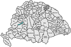
Ung county (in Latin: comitatus Unghvariensis, in Hungarian: Ung (vár)megye in Slovak also: Užský komitát/ Užská župa / Užská stolica) was an administrative county (comitatus) of the Kingdom of Hungary. Its territory is now in eastern Slovakia (1/3) and western Ukraine (2/3).
Geography
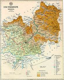
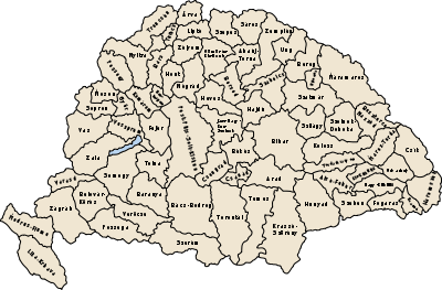
Ung county shared borders with the Austrian crownland Galicia (now in Poland and Ukraine) and the Hungarian counties Bereg, Szabolcs and Zemplén. It was situated between the Carpathian Mountains in the north, the rivers Tisza and Latorca (present-day Latorica) in the south, and the river Laborc (present-day Laborec) in the west. The rivers Latorca and Ung (present-day Uzh) flowed through the county. Its area was 3230 km² around 1910.
Capitals
Initially, the capital of the county was the Uzhhorod Castle (Hungarian: Ungvári vár), later the town of Ungvár (present-day Uzhhorod).
History
Ung is one of the oldest counties of the Kingdom of Hungary. In the aftermath of World War I, most of Ung county became part of newly formed Czechoslovakia, as recognized by the concerned states in the 1920 Treaty of Trianon. The town of Záhony and the village of Győröcske remained in Hungary (county Szabolcs-Ung).
Following the provisions of the First Vienna Award, all but the westernmost part of the county became part of Hungary again in November 1938. After World War II, this westernmost part was returned to Czechoslovakia. The rest (except Záhony and Győröcske) became part of the Soviet Union, Ukrainian SSR, Zakarpattia Oblast.
Demographics
1900
In 1900, the county had a population of 153,266 people and was composed of the following linguistic communities:[1]
Total:
- Ruthenian: 55,742 (36.4%)
- Hungarian: 46,306 (30.2%)
- Slovak: 42,876 (28.0%)
- German: 7,099 (4.6%)
- Romanian: 199 (0.1%)
- Croatian: 192 (0.1%)
- Serbian: 3 (0.0%)
- Other or unknown: 849 (0.6%)
According to the census of 1900, the county was composed of the following religious communities:[2]
Total:
- Greek Catholic: 83,936 (54.8%)
- Roman Catholic: 32,904 (21.5%)
- Calvinist: 19,003 (12.4%)
- Jewish: 16,776 (10.9%)
- Lutheran: 562 (0.4%)
- Greek Orthodox: 56 (0.0%)
- Unitarian: 12 (0.0%)
- Other or unknown: 17 (0.0%)
1910

In 1910, the county had a population of 161,989 people and was composed of the following linguistic communities:[3]
Total:
- Ruthenian: 61,711 (38.1%)
- Hungarian: 53,824 (33.2%)
- Slovak: 36,364 (22.4%)
- German: 8,383 (5.2%)
- Romanian: 133 (0.1%)
- Croatian: 82 (0.0%)
- Serbian: 8 (0.0%)
- Other or unknown: 1,584 (1.0%)
According to the census of 1910, the county was composed of the following religious communities:[4]
Total:
- Greek Catholic: 89,149 (55.0%)
- Roman Catholic: 34,549 (21.3%)
- Calvinist: 20,092 (12.4%)
- Jewish: 17,587 (10.9%)
- Lutheran: 582 (0.3%)
- Greek Orthodox: 90 (0.1%)
- Unitarian: 21 (0.0%)
- Other or unknown: 19 (0.0%)
Subdivisions
In the early 20th century, the subdivisions of Ung county were:
| Districts (járás) | |
|---|---|
| District | Capital |
| Nagyberezna | Nagyberezna, UA Velykyi Bereznyi |
| Nagykapos | Nagykapos, SK Veľké Kapušany |
| Perecseny | Perecseny, UA Perechyn |
| Szerednye | Szerednye, UA Serednye |
| Szobránc | Szobránc, SK Sobrance |
| Ungvár | Ungvár, UA Uzhhorod |
| Urban districts (rendezett tanácsú város) | |
| Ungvár, UA Uzhhorod | |
The towns of Veľké Kapušany and Sobrance are now in Slovakia; the other towns mentioned are in Ukraine.
References
- ↑ "KlimoTheca :: Könyvtár". Kt.lib.pte.hu. Retrieved 2012-06-26.
- ↑ "KlimoTheca :: Könyvtár". Kt.lib.pte.hu. Retrieved 2012-06-26.
- ↑ "KlimoTheca :: Könyvtár". Kt.lib.pte.hu. Retrieved 2012-06-26.
- ↑ "KlimoTheca :: Könyvtár". Kt.lib.pte.hu. Retrieved 2012-06-26.