Máramaros County
| Máramaros County Comitatus Maramarosiensis Máramaros vármegye Komitat Maramuresch Comitatul Maramureș Комітат Марамарош | |||||
| County of the Kingdom of Hungary | |||||
| |||||
|
Coat of arms | |||||
 | |||||
| Capital | Máramarossziget 47°56′N 23°53′E / 47.933°N 23.883°ECoordinates: 47°56′N 23°53′E / 47.933°N 23.883°E | ||||
| History | |||||
| • | Established | 12th century | |||
| • | Treaty of Trianon | 4 June 1920 | |||
| Area | |||||
| • | 1910 | 9,716 km2 (3,751 sq mi) | |||
| Population | |||||
| • | 1910 | 357,700 | |||
| Density | 36.8 /km2 (95.4 /sq mi) | ||||
| Today part of | | ||||
| Sighetu Marmației is the current name of the capital. | |||||

Máramaros (Romanian: Maramureș; Rusyn: Мараморош / Maramorosh, Мараморыш / Maramorŷsh; Ukrainian: Мармарощина – Marmaroshchyna; Latin: Marmatia) was an administrative county (comitatus) of the Kingdom of Hungary. Its territory is now in north-western Romania and western Ukraine. The capital of the county was Máramarossziget (present-day Sighetu Marmației).
Geography
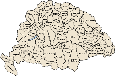
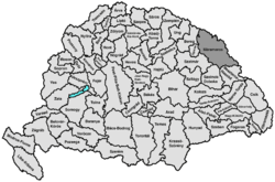
Máramaros county shared borders with the Austrian crownlands Galicia (now in Poland and Ukraine) and Bukovina (now in Romania and Ukraine) and the Hungarian counties Bereg, Ugocsa, Szatmár, Szolnok-Doboka and Beszterce-Naszód. It was situated on both sides of the river Tisza, and in the Carpathian mountains. Its area was 9720 km² around 1910.
History
The first mention of the county in the written sources is from 1119 ("cum in Maramorisio tempore venationis venatum ivissemus"). In the 13th century, it was almost uninhabited or very scarcely inhabited. The growth of its population started when the five crown cities (Máramarossziget, Hosszúmező, Huszt, Técső, Visk) were founded in the 14th century.[1] In 1920, after the Treaty of Trianon, the northern part of the county became part of newly formed Czechoslovakia (Subcarpathian Ruthenia). The southern part (including Sighetu Marmației) became part of Romania.
The northern part was returned to Hungary by the First Vienna Award in 1938 and by the annexation of the remainder of Carpthian Ruthenia after Czechoslovakia ceased to exist in 1939. The county Máramaros was recreated, with Huszt as capital. The southern part was from 1940 part of Hungary until the end of World War II. Afterwards, the formerly Czechoslovak part of Máramaros county became part of the Soviet Union, Ukrainian SSR, Zakarpattia Oblast. Since 1991, when the Soviet Union split up, the Zakarpattya region is part of Ukraine.
The southern part of the county is now part of the Romanian county Maramureș.
Demographics
1900
In 1900, the county had a population of 309,598 people and was composed of the following linguistic communities:[2]
Total:
- Ruthenian: 143,621 (46.4%)
- Romanian: 74,978 (24.2%)
- German: 47,449 (15.3%)
- Hungarian: 42,403 (13.7%)
- Slovak: 545 (0.2%)
- Croatian: 79 (0.0%)
- Serbian: 4 (0.0%)
- Other or unknown: 519 (0.2%)
According to the census of 1900, the county was composed of the following religious communities:[3]
Total:
- Greek Catholic: 220,817 (71.3%)
- Jewish: 56,006 (18.1%)
- Roman Catholic: 23,430 (7.6%)
- Calvinist: 8,918 (2.9%)
- Lutheran: 310 (0.1%)
- Eastern Orthodox: 88 (0.0%)
- Unitarian: 24 (0.0%)
- Other or unknown: 5 (0.0%)
1910
In 1910, the county had a population of 357,705 people and was composed of the following linguistic communities:[4]
Total:
- Ruthenian: 159,489 (44.6%)
- Romanian: 84,510 (23.6%)
- German: 59,552 (16.7%)
- Hungarian: 52,964 (14.8%)
- Slovak: 503 (0.1%)
- Croatian: 41 (0.0%)
- Serbian: 6 (0.0%)
- Other or unknown: 640 (0.2%)
According to the census of 1910, the county was composed of the following religious communities:[5]
Total:
- Greek Catholic: 254,215 (71.1%)
- Jewish: 65,694 (18.4%)
- Roman Catholic: 26,204 (7.3%)
- Calvinist: 9,646 (2.7%)
- Eastern Orthodox: 1,437 (0.4%)
- Lutheran: 464 (0.1%)
- Unitarian: 42 (0.0%)
- Other or unknown: 3 (0.0%)
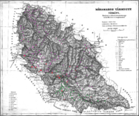
Subdivisions
In the early 20th century, the subdivisions of Máramaros county were:
| Districts (járás) | |
|---|---|
| District | Capital |
| Dolha | Dolha, UA Dovhe |
| Huszt | Huszt, UA Khust |
| Izavölgy | Dragomérfalva, RO Dragomirești |
| Ökörmező | Ökörmező, UA Mizhhir'ya |
| Sugatag | Aknasugatag, RO Ocna Șugatag |
| Sziget | Máramarossziget, RO Sighetu Marmației |
| Taracviz | Taracköz, UA Teresva |
| Técső | Técső, UA Tiachiv |
| Tiszavölgy | Rahó, UA Rakhiv |
| Visó | Felsővisó, RO Vișeu de Sus |
| Urban districts (rendezett tanácsú város) | |
| Máramarossziget, RO Sighetu Marmației | |
Rakhiv, Teresva, Tiachiv, Khust, Dovhe and Mizhhir'ya are now in Ukraine; Sighetu Marmației, Ocna Șugatag, Dragomirești and Vișeu de Sus are now in Romania.
References
- ↑ Györffy György: Máramarosvármegye (4: 118)
- ↑ "KlimoTheca :: Könyvtár". Kt.lib.pte.hu. Retrieved 2012-06-26.
- ↑ "KlimoTheca :: Könyvtár". Kt.lib.pte.hu. Retrieved 2012-06-26.
- ↑ "KlimoTheca :: Könyvtár". Kt.lib.pte.hu. Retrieved 2012-06-26.
- ↑ "KlimoTheca :: Könyvtár". Kt.lib.pte.hu. Retrieved 2012-06-26.