Rhos-y-gwaliau
| Rhos-y-gwaliau | |
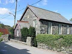 Village chapel |
|
 Rhos-y-gwaliau |
|
| Population | 86 (2011) |
|---|---|
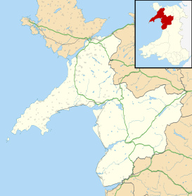
| OS grid reference | SH9434 |
| – Cardiff | 140 miles |
| Community | Llandderfel |
| Principal area | Gwynedd |
| Country | Wales |
| Sovereign state | United Kingdom |
| Post town | BALA |
| Postcode district | LL23 |
| Dialling code | 01678 |
| Police | North Wales |
| Fire | North Wales |
| Ambulance | Welsh |
| EU Parliament | Wales |
| UK Parliament | Dwyfor Meirionnydd |
| Welsh Assembly | Dwyfor Meirionnydd |
Coordinates: 52°54′00″N 3°34′24″W / 52.9001°N 3.5732°W
Rhos-y-gwaliau is a small hamlet in Meirionnydd, Gwynedd, North Wales, about 1.5 miles (2.4 km) south-east of Bala. It is home to the Rhos y Gwaliau Outdoor Activity Centre and a now disused Victorian chapel, built for the Calvinistic Methodists.
The Berwyn Mountains rise behind the village. The village lies towards the lower end of the narrow Hirnant valley formed by the Hirnant stream, which rises at the crest of the Berwyn's and flows into the River Dee.
Close to the village is Plas Rhiwaedog, the manor house of the ancient Rhiwaedog estate.
Regional Cycle Route 12 passes through the village.
External links

This article is issued from Wikipedia - version of the 5/13/2016. The text is available under the Creative Commons Attribution/Share Alike but additional terms may apply for the media files.