Hayden Valley
| Hayden Valley | |
|---|---|
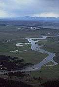
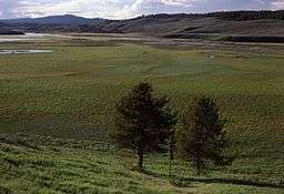 Hayden Valley, 1977 | |
| Name origin: Named for Ferdinand V. Hayden | |
| State | Wyoming |
| Region | Yellowstone National Park |
| Location | 44°38′38″N 110°27′20″W / 44.64389°N 110.45556°WCoordinates: 44°38′38″N 110°27′20″W / 44.64389°N 110.45556°W |
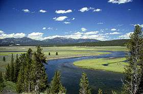
Hayden Valley is a large, sub-alpine valley in Yellowstone National Park straddling the Yellowstone River between Yellowstone Falls and Yellowstone Lake. The valley floor along the river is an ancient lake bed from a time when Yellowstone Lake was much larger. The valley is well known as one of the best locations to view wildlife in Yellowstone.
History
The valley was the natural route to Yellowstone Lake as trappers, explorers and natives made their way up the Yellowstone River. On August 29, 1870 when Henry D. Washburn and Gustavus Cheyney Doane ascended Mount Washburn during the Washburn-Langford-Doane Expedition, they saw the great expanse of the Hayden Valley between Yellowstone Falls and the lake.
In Doane's journal he described the valley as seen from Mount Washburn thus:
A grassy valley, branching between low ridges, running from the river toward the center of the basin. A small stream rose in this valley, breaking through the ridges to the west in a deep cañon, and falling into the channel of the Yellowstone, which here bears in a northeast course, flowing in view as far as the confluence of the small stream, thence plunged into the Grand Cañon, and hidden from sight. No falls can be seen, but their location is readily detected by the sudden disappearance of the river; beyond this open valley the basin appears to be filled with a succession of low, converging ridges, heavily timbered, and all of about an equal altitude. To the south appears a broad sheet of water -- the Yellowstone Lake.[1]
Although it is clear that the valley is named in honor of Ferdinand Vandeveer Hayden[2] and his geological surveys of the Yellowstone region (his 1871 survey led to the creation of the park), there is little definitive evidence as to who actually named the valley. Some credit the Earl of Dunraven, during his visit in 1872, but the name first appeared on maps in 1880 in an annual report from superintendent Philetus Norris.[3]
Location
The Hayden valley is approximately 7 miles (11 km) long north to south and 7 miles (11 km) wide east to west and occupies about 50 square miles (130 km2) of the park. It lies mostly the west of the Yellowstone River between Canyon and Yellowstone Lake. The Canyon to Lake section of the Grand Loop Road follows the eastern side of the valley near the river.
Geothermal features
The geothermal features that are scattered around the valley are not as impressive as those of the large geyser basins, but in many case they were the first to be discovered and described by the early explorers. They include Mud Volcano, Mud Geyser, Sulphur Caldron, and Black Dragon Caldron at the southern end of the valley and Sulphur Spring in the Crater Hills group further north and west of the river.
Sensitive habitat
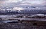
The Hayden Valley is outstanding wildlife habitat and is frequented by buffalo, elk, grizzly bears, coyote and a host of smaller mammals and birds. To protect this habitat and prevent disturbing wildlife, the valley is closed to off-trail foot travel. Two trails make the valley accessible for hikers—the Hayden Valley trail and the Mary Mountain trail. The valley trail parallels the river on the eastern side of the valley from Lake to Canyon, while the Mary Mountain trail skirts the northern edge of the valley along Alum Creek on its way to the Canyon-Lake road. All the rivers, creeks and ponds in the valley are closed to fishing,.[4][5]
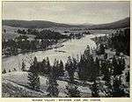
| Images of Hayden Valley | ||||||||
|---|---|---|---|---|---|---|---|---|
|
Notes
- ↑ The report of Lieutenant Gustavus C. Doane upon the so-called Yellowstone Expedition of 1870, presented to the Secretary of War, February 1871
- ↑ Gannett, Henry (1905). The Origin of Certain Place Names in the United States. Govt. Print. Off. p. 153.
- ↑ Haines, Aubrey L. (1996). Yellowstone Place Names-Mirrors of History. Niwot, CO: University Press of Colorado. pp. 198–99. ISBN 0-87081-382-X.
- ↑ Schneider, Bill (2003). Hiking Yellowstone National Park. Guilford, CT: Globe Pequot Press. pp. 219–225. ISBN 0-7627-2539-7.
- ↑ 2007 Yellowstone National Park Fishing Regulations
- ↑ Haynes, F. Jay (1909). Haynes Souvenir Album-Yellowstone National Park. St Paul, MN: Frank J. Haynes.
Yellowstone National Park - Lake and Environs | ||
|---|---|---|
Historic structures and other attractions in the Yellowstone Lake, West Thumb, South and East Entrance areas | ||
| Structures and History |  | |
| West Thumb Geyser Basin | ||
| Geography and Geology |
| |
| ||
Cheyenne (capital) | |
| Topics |
|
| Society |
|
| Regions | |
| Cities | |
| Counties | |