Mount Schurz
| Mount Schurz | |
|---|---|
 1977 | |
| Highest point | |
| Elevation | 11,007 ft (3,355 m) [1] |
| Coordinates | 44°20′33″N 110°04′19″W / 44.34250°N 110.07194°WCoordinates: 44°20′33″N 110°04′19″W / 44.34250°N 110.07194°W [1] |
| Naming | |
| Pronunciation | /ˈʃɜːrts/ |
| Geography | |
| Location |
Yellowstone National Park, Park County, Wyoming, US |
| Parent range | Absaroka Range |
| Topo map | Eagle Peak |
Mount Schurz el. 11,007 feet (3,355 m) is a mountain peak in the Absaroka Range in Yellowstone National Park. Mount Schurz is the second highest peak in Yellowstone. The mountain was originally named Mount Doane by Henry D. Washburn during the Washburn–Langford–Doane Expedition in 1871. Later the name Mount Doane was given to another peak in the Absaroka Range by geologist Arnold Hague. In 1885, Hague named the mountain for the 13th U.S. Secretary of the Interior, Carl Schurz (1877–1881). Schurz was the first Secretary of the Interior to visit Yellowstone and a strong supporter of the national park movement.[2]
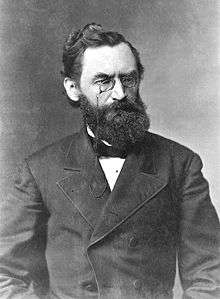
Carl Schurz, namesake of Mount Schurz
See also
Notes
- 1 2 "Mount Schurz". Geographic Names Information System. United States Geological Survey.
- ↑ Whittlesey, Lee (1988). Yellowstone Place Names. Helena, MT: Montana Historical Society Press. pp. 106–107. ISBN 0-917298-15-2.
Yellowstone National Park - Lake and Environs | ||
|---|---|---|
Historic structures and other attractions in the Yellowstone Lake, West Thumb, South and East Entrance areas | ||
| Structures and History | 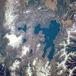 | |
| West Thumb Geyser Basin | ||
| Geography and Geology |
| |
| ||
Cheyenne (capital) | |
| Topics |
|
| Society |
|
| Regions | |
| Cities | |
| Counties | |
This article is issued from Wikipedia - version of the 3/15/2016. The text is available under the Creative Commons Attribution/Share Alike but additional terms may apply for the media files.