Hebden, North Yorkshire
| Hebden | |
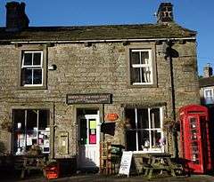 Hebden Post Office (now closed) |
|
 Hebden |
|
| Area | 5.6 sq mi (15 km2) [1] |
|---|---|
| Population | 230 (2011 Census)[2] |
| – density | 41/sq mi (16/km2) |
| OS grid reference | SE02596317 |
| – London | 190 mi (310 km) SSE |
| Civil parish | Hebden |
| District | Craven |
| Shire county | North Yorkshire |
| Region | Yorkshire and the Humber |
| Country | England |
| Sovereign state | United Kingdom |
| Post town | SKIPTON |
| Postcode district | BD23 |
| Dialling code | 01756 |
| Police | North Yorkshire |
| Fire | North Yorkshire |
| Ambulance | Yorkshire |
| EU Parliament | Yorkshire and the Humber |
| UK Parliament | Skipton and Ripon |
Coordinates: 54°03′50″N 1°57′43″W / 54.064°N 1.962°W
Hebden (/ˈhɛb.dən/ HEB-dərn) is a village and civil parish in the Craven district of North Yorkshire, England, and one of four villages in the ecclesiastical parish of Linton. It lies near Grimwith Reservoir and Grassington, in Wharfedale in the Yorkshire Dales National Park. In 2011 it had a population of 230.
Hebden has a church, a chapel, a hotel and public house, a tea room, a community hall, a small general store associated with the pub, and is well served by buses. Until 1983 it had a primary school. Hebden straddles a cross roads. The east-west B6265 road connects it with Grassington 1.7 miles (2.7 km) to the west, and from there south to the market town of Skipton, 11.5 miles (18.5 km) from Hebden. To the east, the road crosses a bridge over Hebden Gill, built in 1827, and thence over the watershed to Pateley Bridge in Nidderdale, 8.5 miles (13.7 km) distant.
Main Street, the village high street, continues south as Mill Lane, towards the bank of the River Wharfe and the villages of Hartlington and Burnsall, the latter being just over 2 miles (3.2 km) away. The road to the north runs to the small hamlet of Hole Bottom, from there continuing as a track onto Grassington Moor.
The layout of the village largely originates from manorial times, but during the 19th century the village grew to become a substantial industrial community with lead mining and a cotton mill as the main sources of employment. Since then it has reverted to a rural community, and is a focal point for walkers and cyclists wishing to enjoy the local countryside.
History
The name Hebden may be derived from either heope, Old English for a rose-hip or heopa, Old English for a bramble, and dene, Old English for a valley,[3] or from the Scandinavian Hebban, a topographical description of a ridge forming an elevated site above a small valley.[4] Two Bronze Age stone circles and remnants of huts on the moors above the village show that the area has been settled since earliest times, [5][6] and a hoard of 33 silver dinari dating from 30 to 170 AD found in a local field indicates that the Romans had a presence.[7] The hoard is now on display at the Craven Museum & Gallery.[8][9][10] An Iron Age or Romano-British settlement has been tentatively identified on the banks of Gate Up Gill on the moors to the north-west of the village.[11] Place names such as Scale Haw indicate the Norse left their influence.[12] There is no documentary record of the area until a mention in the Domesday Book of 1086, in which the settlement was referred to as Hebedene held by Osbern d'Arques, of Thorpe Arch. At the time of the Conquest the land was held by Dreng, which is a Nordic name.[13][14][15][16]
During medieval times, an important east-west droving route used to move sheep between winter pastures around Fountains Abbey and summer pastures around Malham, crossed the Hebden Beck at Hebden.[17] It broadly followed the line of the North Craven Fault avoiding the moorland peat bogs, and became a busy packhorse route for traders.[18]
Although no property in the village is older than the early 17th century,[19] its layout reflects its development in medieval times as a planned village. Eight toft compartments are discernible to the west of Main Street, and the outline of the four surrounding common fields, now divided, may be identified from the pattern of dry stone walls. The fields were largely arable, providing the village with most of its food requirements, but are now farmed exclusively for pasture and hay. The village manor house was on land now occupied by Hebden Hall at the south end of Main Street.[20]
The last stretch of Hebden Beck before it reaches the River Wharfe was used to power a corn mill in the Middle Ages,[21] and corn milling survived into the middle of the 19th century.[22] In the 14th century Fountains Abbey had a fulling mill in the village.[23] In 1791 a three-storey cotton mill was built alongside the corn mill. It housed 54 spinning frames and was productive until 1870 when it was driven out of business by the more efficient stream-driven machinery of the industrial revolution.[24] At its peak, the mill employed more than 70 men, women, and children. The building was used for other purposes including a roller skating rink until it was demolished in 1967.[25]
Lead mining on Grassington Moor became important in the 18th century,[26] and as a result of the mines' success, a number of the mine owners promoted the provision of the Grassington to Pately Bridge turnpike road, which was begun in 1760 and provided an all-weather route across the moors for wagons.[27][28] From the early 19th century Hebden was a dormitory village for some miners, contributing to the population rising to more than 500 in the 1830s.[29] In the early 1850s profitable mines were established in the parish to the north of the village on veins associated with Grassington Moor,[30] which helped sustain the population. Although activity continued sporadically into the last decade of the century, the accessible ore was largely exhausted by 1865, and the population declined to a low of 199 in 1901.[31]
As the freeholders shared the mineral royalties,[32] the mines brought prosperity which gave rise to the remodelling and redevelopment of much of the village. Green Terrace, which includes the old post office, was built in the 1870s, and Main Street was transformed from a back lane into the high street.[33] The village school, with working clock and bell tower, was built by the community in 1874,[32] and the stone-built Ibbotson Institute, now the community hall, was completed in 1903.[34]
The coming of the Yorkshire Dales Railway to Threshfield in 1902 opened up Hebden as a destination for day visitors and holiday makers.[35] A purpose-built timber guest house was opened in 1909 at the south end of the village by the Co-operative Holiday Association, founded by Thomas Arthur Leonard. It passed into private hands in 1960, and continued as a holiday centre until 1990, mainly catering for school parties.[36][37] It was demolished in 2016 and replaced with a private residence.[38]
The village stores and post office shut at the end of 2013 after 100 years of trading, and a new store associated with the public house opened at the beginning of 2014, currently run as a community shop.[39][40] The gold painted George V Type B wall post box was removed from the outside wall of the post office, and replaced with a modern gold painted lamp box a few metres away;[41] and the K6 Tudor Crown phone box was decommissioned, and set up at the cross-roads as a street ornament.[42]
Although it now has a number of second homes, holiday cottages and commuters,[43][44] with eight working farms, a fish farm,[45] coach and haulage companies,[46][47] Hebden remains a working and thriving community.
Governance
Hebden was a township in the parish of Linton, part of the east division of the wapentake of Staincliffe and Ewcross in the historic county of the West Riding of Yorkshire.[48] It became a separate civil parish in Skipton Rural District in 1866 as a result of the enactment of the Poor Law Amendment Act 1866. In 1974 it was transferred to Craven District in North Yorkshire as the result of the enactment of the Local Government Act 1972.[49]
Hebden lies in the Skipton and Ripon Parliamentary Constituency, a seat held by Julian Smith MP for the Conservative;[50] and in the Mid-Craven electoral division of North Yorkshire County Council, represented by Conservative party member, Shelagh Marshall.[51][52] Hebden is in the Grassington ward of Craven District, a non-metropolitan district, which is represented by Richard Foster for the Conservative party.[53][54] As it is located within the Yorkshire Dales National Park, the Yorkshire Dales National Park Authority is the local planning authority for the area.[55]
Hebden has a parish council with five independent members supported by a parish clerk. Elections are held every four years, the most recent in 2016.[56] Council meetings are held every six weeks.[57] The parish council's activities are largely funded by income from parish lands in the form of rent, grants, and easements.[58]
Geography

The south-east boundary of Hebden parish is the River Wharfe, 500 feet (150 m) above sea level, and the north-east boundary runs along the Wharfedale-Nidderdale watershed, reaching a height of 1,770 feet (540 m). The upper section of the eastern boundary is Gate Up Gill, one of the main inflows of Grimwith Reservoir. The parish approximates a parallelogram in shape, averaging under 1.5 miles (2.4 km) in width and some 5 miles (8.0 km) in length.[59] To the north, the land rises away from Hebden to the 2,310 feet (700 m) summit of Great Whernside, some 7 miles (11 km) distant.[60]
The habitations and main farming areas are largely confined to the Wharfe valley, and the rest of the parish is mainly rough moorland pasture. The village is on one of several branches of the North Craven Fault where Hebden Beck emerges from the moors through a steep-sided valley into the Wharfe valley, on an ancient east-west route.
Hebden Beck rises on Grassington Moor some 2.5 miles (4.0 km) from the village, but the main valley continues north as a dry valley, until it reaches Mossdale Caverns and the upper flanks of Great Whernside.
The geology is dominated by rocks Carboniferous in age but, as the parish straddles a complex section of the North Craven Fault, it is varied. To the north-east of the village the rocks are predominantly Bowland sandstones and shales, and to the south-east are largely massive limestones. The River Wharfe runs across the limestone, through an impressive gorge at Loup Scar. The mineral veins of the Bowland series have been exploited for lead ore.[61]
Population change
| Population changes in Hebden since 1801 | ||||||||||||||||||||||
|---|---|---|---|---|---|---|---|---|---|---|---|---|---|---|---|---|---|---|---|---|---|---|
| Year | 1801 | 1811 | 1821 | 1831 | 1841 | 1851 | 1861 | 1871 | 1881 | 1891 | 1901 | 1911 | 1921 | 1931 | 1941 | 1951 | 1961 | 1971 | 1981 | 1991 | 2001 | 2011 |
| Population | 342 | 402 | 377 | 491 | 480 | 460 | 435 | 362 | 313 | 209 | 199 | 225 | 343 | 289 | --- | 252 | 221 | 210 | 213 | 202 | 216 | 230 |
| % change | --- | +14.6 | -6.2 | +30.2 | -2.2 | -4.1 | -5.4 | -16.8 | -13.5 | -33.2 | -4.8 | +13.1 | +52.4 | -15.7 | --- | -12.8 | -12.3 | -5.0 | +1.4 | -5.2 | +6.9 | +6.5 |
| Sources: Vision of Britain,[62] Online Historical Population Reports,[63] 2001 UK Census Data, 2011 North Yorkshire County Council | ||||||||||||||||||||||
Landmarks
Hebden is a centre for walking and cycling in Upper Wharfedale. It has an inn,[64] a shop, and a tea room cater for visitors,[65] and within walking distance are the Dales villages of Appletreewick, Burnsall, Thorpe, Linton and Grassington. A gold post box near the old post office commemorates the 2012 Olympic Games rowing gold medal won by Andrew Triggs Hodge, who grew up in the village.[66][67] Grimwith Reservoir, used for wind surfing, dinghy sailing, and bird watching, is 2 miles (3.2 km) to the east along the B6265, and 2 miles (3.2 km) further is Stump Cross Caverns - a show cave. The Dales Cycle Way passes through Hebden on its way from Appletreewick to Grassington.[68]
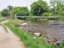
Because of its proximity to the Craven Fault, the scenery is varied. The Dales Way[69] passes through the parish along the banks of the River Wharfe between Burnsall and Grassington, mainly through limestone pastures but occasionally, as at Loup Scar and Linton Falls, through limestone gorges and past waterfalls. It crosses the Wharfe at Hebden on a wrapped steel-cable suspension bridge, a few yards upstream of the reconstructed course of medieval stepping stones. The bridge was built in 1885 by local blacksmith William Bell, and paid for by public subscription. Made of recycled materials, it originally had a central supporting pier (the base of which can be seen in low water conditions), that was removed when the span was raised in 1937 after being damaged in a heavy flood.[70] The bridge has been conserved and is a landmark on the river-side path.[71]
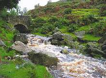
Hebden Beck flows down from Grassington Moor, which is dominated by the long-abandoned remains of the lead mining industry, through a rugged and wooded gill, past the hamlet of Hole Bottom, made famous by William Riley's novel Jerry and Ben,[72][73] and then over the 16 feet (5 m) Scala Falls.[74] A popular walk is an 8 miles (13 km) circuit up to Grassington Moor, and thence to Grassington, returning along the River Wharfe.[75] South of Hebden, the edge of the limestone is heralded by a number of text-book examples of reef knolls, including Elbolton Hill, Stebden Hill, and Kail Hill, which are the conical remnants of limestone reef structures.[76] Behind the reef knolls is a large expanse of Grassington Grit grouse moor, Thorpe Fell and Burnsall Fell, where walking may be enjoyed - especially around the edges.[77]
Conservation area

In 2006 the Yorkshire Dales National Park Authority designated Hebden a conservation area. In the proposal it was stated that:
"The special character of Hebden is defined by a historic settlement pattern of great significance together with a collection of important listed buildings and a group of unlisted buildings which, although essentially vernacular and humble in architectural terms, combine well together to create a harmonious and generally high quality environment of buildings, open spaces and tree cover. In addition, the setting is very distinctive with natural topography of surrounding hills and adjacent steep sided valley combining with a man made agricultural landscape of some age and significance in its own right."[78]
Sport
Hebden Sports Day is held annually on August Bank Holiday. Dating back to the nineteenth century, Hebden Sports provides a variety of running races, novelty races, and entertainments for all age groups.[79] It has hosted the professional Hebden Fell Race since at least 1922,[80] which was a regular feature on the British Open Fell Runners Association calendar until 2013. The village cricket team, the Hebden Hedgehogs plays in the Underdales League, a league with its own set of idiosyncratic rules.[81] Rugby union, football, and crown green bowling facilities are available at Grassington and Threshfield.[82][83][84]
Religion
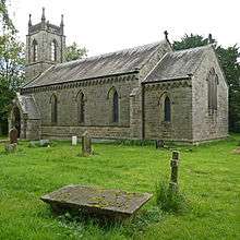
Hebden is part of the ecclesiastical parish of Linton in the Skipton deanery of the Diocese of Bradford, and its church was built as a chapel of ease to St Michael and All Angels Church in Linton in 1841 and dedicated to St Peter.[85][86][87][88] Until then, parishioners attended church in Linton a distance of some 1.5 mi (2.4 km) using the church path across fields to stepping stones crossing the Wharfe.[89] St Peter's Church was built on land donated by the Rev Henry Bailey, and was designed by the curate, the Rev. John Feron, in the Gothic Revival style.[90] It is a Grade II listed building.[87] Its pipe organ was built by Harrison & Harrison of Durham and was dedicated in 1894. It was refurbished in 2010 by A. Carter of Wakefield, and has been granted a Grade II Historic Organ Certificate.[91] The churchyard contains one Commonwealth war grave, of a Royal Air Force airman of the Second World War.[92]
The Methodist church built in 1812 was part of the Skipton and Grassington Methodist Circuit, but it closed in October 2016 with its membership transferring to Grassington Methodist Church.[88][93]
Public services and transport
Local medical facilities are provided by the medical centre in Grassington,[94] and hospital facilities are provided by the Airedale NHS Trust[95] at Airedale General Hospital in Steeton, some 18 miles (29 km) away. Ambulance services are provided by the Yorkshire Ambulance Service NHS Trust,[96] who have an ambulance station in Grassington.
Fire fighting services are provided by North Yorkshire Fire and Rescue Services, who maintain a retained fire station in Grassington,[97] and cave and mountain rescue services are provided by the Upper Wharfedale Fell Rescue Association,[98] based in Grassington. Police Services are provided by the North Yorkshire Police. The nearest manned police station is in Skipton, but there is a team of officers based in Grassington.[99]
Regional television services are provided by BBC Yorkshire and Yorkshire Television. Cable Internet access is not available in the village, and the ADSL broadband speed is about 2.5 Mbit/s.[100] Fast broadband is available from BT Infinity.[101]
Electricity distribution is the responsibility of Northern Powergrid (Yorkshire),[102] which is wholly owned by MidAmerican Energy Holdings Company.[103] There is no domestic gas mains supply. Water is supplied by Yorkshire Water from Embsay Reservoir.[104] Yorkshire Water is responsible for wastewater disposal, and a small-scale treatment plant is located adjacent to the River Wharfe south of Hebden Beck. Refuse collection is handled by Craven District Council,[105] and North Yorkshire County Council provides a household waste and recycling centre at Skibeden,[106] between Bolton Abbey and Skipton.
The village is served by a minibus service to Ilkley via Grassington twice a week in summer, and once a week in winter.[107][108] The nearest railway station is in Skipton, with services to Leeds, Bradford, Carlisle, and Carnforth, and the nearest international airport is Leeds Bradford Airport.
References
Notes
- ↑ "Heavitree - Hednesford". A Topographical Dictionary of England (1848). British History Online. Retrieved 8 December 2013.
- ↑ "2013 Population Estimates Parishes" (PDF). North Yorkshire County Council. North Yorkshire County Council. Retrieved 17 February 2016.
- ↑ Thurlow, William (1979). Yorkshire Place-Names. Dalesman Books. p. 30.
- ↑ "Hebden - Conservation Area Character Appraisal" (PDF). Yorkshire Dales National Park Authority. Retrieved 16 December 2013.
- ↑ "Dumpit Hill A, Hebden, Grassington, North Yorkshire". The Northern Antiquarian. Retrieved 8 December 2013.
- ↑ Joy (2002), pp. 14–15.
- ↑ "Dales treasure hunter finds rare Roman coins". Craven Herald and Pioneer. Newsquest Media Group. 8 December 2013. Retrieved 8 December 2013.
- ↑ "Coin Hoard". www.finds.org.uk. Portable Antiquities scheme. Retrieved 16 March 2016.
- ↑ "V&A Purchase Grant Fund Awards 2012/2013" (PDF). www.vam.ac.uk. Victoria and Albert Museum. Retrieved 16 March 2016.
- ↑ "Craven Museum secures grant to buy Roman coins". Craven Herald & Pioneer. Retrieved 16 March 2016.
- ↑ "Iron Age/Romano-British Settlement, Groove Gill". Archaeology Data Service. University of York. Retrieved 8 December 2013.
- ↑ Joy (2002), p. 16.
- ↑ "Open Domesday Hebden". Open Domesday. Retrieved 11 December 2013.
- ↑ "National Archives: Domesday Book: Hebden, Yorkshire". Domesday Book. The National Archives. Retrieved 8 December 2013.
- ↑ "Osbern de Arches (d'Arques) (c.1059 - c.1115)". geni.com. Retrieved 8 December 2013.
- ↑ "The Internet Surname Database". Name Origin Research. Retrieved 18 December 2013.
- ↑ Raistrick (1976), p. 5.
- ↑ Joy (2002), pp. 7,20–21.
- ↑ "British Listed Buildings Online". Mark Goodge. Retrieved 8 December 2013.
- ↑ Joy (2002), pp. 18–26.
- ↑ Joy (2002), p. 19.
- ↑ Joy (2002), p. 46.
- ↑ Raistrick (1976), p. 15
- ↑ "Hebden cotton mill". outofoblivion.org. Retrieved 12 December 2013.
- ↑ Joy (2002), pp. 46–50.
- ↑ Raistrick, Arthur (1973). Lead Mining in the Mid-Pennines. Truro: D. Bradford Barton Ltd. p. 90.
- ↑ Raistrick (1973), p. 102.
- ↑ Joy (2002), pp. 38–39.
- ↑ Joy (2002), p. 50.
- ↑ Gill, M.C. (1994). The Wharfedale Mines. British Mining. 49. Keighley: Northern Mine Research Society. pp. 97–120. ISBN 0-901450-41-3.
- ↑ "County of York Census Data 1901". Online Historical Population Reports. University of Essex. Retrieved 8 December 2013.
- 1 2 Raistrick, Elizabeth (1971). Village Schools. An Upper Wharfedale History. Clapham (via Lancaster): The Dalesman Publish Company. pp. 41–44.
- ↑ Joy (2002), pp. 69–70.
- ↑ Joy (2002), p. 80.
- ↑ Awdry, Christopher (1990). Encyclopaedia of British Railway Companies. Sparkford: Patrick Stephens Ltd. ISBN 1-8526-0049-7. OCLC 19514063. p. 112.
- ↑ Joy (2002), p. 83.
- ↑ "CHA Guest House, Hebden". outofoblivion.org. Retrieved 30 October 2014.
- ↑ "Planning Application Details". Yorkshire Dales National Park. Yorkshire Dales National Park Authority. Retrieved 30 November 2016.
- ↑ "Hebden Village Stores and Post Office to close". Craven Herald and Pioneer. Newsquest (Yorkshire & North East) Ltd. 27 December 2013. Retrieved 2 June 2014.
- ↑ "Opening of new community-run Hebden Village Store put back to June 1". Craven Herald and Pioneer. Newsquest (Yorkshire & North East) Ltd. 12 May 2016. Retrieved 14 May 2016.
- ↑ "A-Z List of Postboxes" (PDF). What Do They Know. Retrieved 13 September 2015.
- ↑ "Hebden phone box on the move after standing outside former post office since 1936". Craven Herald and Pioneer. Newsquest (Yorkshire & North East) Ltd. 19 June 2015. Retrieved 21 June 2015.
- ↑ "2001 Census: Key Statistics: Parish Profile - Parish Profile - Accommodation and Tenure : Area: Hebden CP (Parish)". Neighbourhood Statistics. Office for National Statistics. Retrieved 19 September 2010.
- ↑ "2001 Census: Key Statistics: Parish Profile - Work and Qualifications: Area: Hebden CP (Parish)". Neighbourhood Statistics. Office for National Statistics. Retrieved 8 December 2013.
- ↑ "All About Northern Trout". Northern Trout. Brow Well Fisheries Ltd. Retrieved 1 March 2014.
- ↑ "Hargreaves Coaches". Hargreaves Coaches Ltd. Retrieved 8 December 2013.
- ↑ "Longthorne of Hebden". Longthorne of Hebden Ltd. Retrieved 8 December 2013.
- ↑ "Heavitree - Hednesford". A Topographical Dictionary of England (1848). British History Online. Retrieved 8 December 2013.
- ↑ "Hebden Tn/CP through time". A Vision of Britain through Time. University of Portsmouth. Retrieved 8 December 2013.
- ↑ "Election 2015 Skipton & Ripon 2010". BBC News. Retrieved 11 May 2016.
- ↑ "Mid-Craven division results". North Yorkshire County Council. Retrieved 10 May 2016.
- ↑ "Councillor Shelagh Marshall". North Yorkshire County Council. Retrieved 10 May 2016.
- ↑ "Craven District Council 2016 Election Results". Craven District Council. Retrieved 10 May 2016.
- ↑ "Councillor Richard Foster". Craven District Council. Retrieved 10 May 2016.
- ↑ "Planning". The Yorkshire Dales National Park Authority. Retrieved 24 January 2013.
- ↑ "Parish Council Election Results 2016". Craven District Council. Retrieved 10 May 2016.
- ↑ "Hebden". Craven District Council. Retrieved 24 May 2012.
- ↑ "Hebden Parish Council Newsletter" (PDF). Hebden Parish Council. Retrieved 24 May 2012.
- ↑ "Hebden Parish Council Boundaries". MapIt: UK. Retrieved 13 March 2014.
- ↑ 1:25000 Explorer Map: Yorkshire Dales Southern & Western Areas (Map) (A1 ed.). Ordnance Survey. ISBN 9780319236550.
- ↑ W. W., Black (1950). The Carboniferous Geology of the Grassington Area. Proceedings of the Yorkshire Geological Society. 28. pp. 29–42. ISSN 0044-0604.
- ↑ "Hebden: total population". Vision of Britain. Retrieved on 1 November 2011.
- ↑ "Census". Online Historical Population Reports. Retrieved on 1 November 2011.
- ↑ "Clarendon Hotel". Retrieved 6 December 2013.
- ↑ "Old School Tea Room, Hebden". Retrieved 6 December 2013.
- ↑ "Gold Post Boxes". Royal Mail Group. Retrieved 6 December 2013.
- ↑ "Stamp of approval for Olympic gold medal winner Andy Hodge". Craven Herald and Pioneer. 9 August 2012. Retrieved 6 December 2013.
- ↑ "Route Information". Cycle the Yorkshire Dales. Yorkshire Dales National Park Authority. Retrieved 14 June 2015.
- ↑ Hanlon, Paul (1998). Dales Way Companion. Hillside Publications. p. 29. ISBN 1-870141-09-1.
- ↑ Lodge, Eric (1994). A Wharfedale Village. Burnsall: Eric Lodge. p. 124.
- ↑ Joy (2002), pp. 77–78.
- ↑ Joy, David (1991). Uphill to Paradise. Hebden, Skipton: Jerry and Ben's.
- ↑ "William Riley's Books". Retrieved 6 December 2013.
- ↑ Fellows, Griffith (2003). The Waterfalls of England. Sigma Leisure. p. 113. ISBN 1-85058-767-1.
- ↑ Unsworth, Walt (1989). Classic Walks in the Yorkshire Dales. Yeovil: Oxford Illustrated Press Limited. pp. 113–117. ISBN 1-85648-207-3.
- ↑ Ramsbottom, W.H.C.; Goosens, R.F.; Smith, E.G.; Calver, M.A. (1974). Rayner, D.H.; Hemingway, J.E., eds. The Geology and Mineral Resources of Yorkshire. Yorkshire Geological Society. pp. 61–64.
- ↑ "Walk route map ny124 Rylstone Fell, Cracoe Fell, Thorpe Fell Top and Embsay Moor from Embsay". go4awalk.com. Retrieved 21 October 2016.
- ↑ "Proposed Conservation Area Designation for the Village of Hebden" (PDF). Yorkshire Dales National Park Authority. Retrieved 6 December 2013.
- ↑ Benn, Victoria. "Pillow fighting, tug of war and smoking races at Hebden Sports". Craven Herald and Pioneer. Newsquest (Yorkshire & North East) Ltd. Retrieved 6 December 2013.
- ↑ Smith, Bill (1985). Stud Marks on the Summit. Preston: SKG Publications. p. 20. Retrieved 26 August 2013.
- ↑ Berry, Chris. "Bails in the Dales". Yorkshire Post. Johnston Publishing Ltd. Retrieved 6 December 2013.
- ↑ "Grassington United Football Club". Retrieved 6 December 2013.
- ↑ "Wharfedale Rugby Union Football Club". Retrieved 6 December 2013.
- ↑ "Grassington & District Bowling Club". Retrieved 6 December 2013.
- ↑ "The Diocese of Bradford". Retrieved 5 March 2010.
- ↑ "St. Peter's Church, Hebden". Retrieved 5 March 2010.
- 1 2 Historic England. "Church of St. Peter, Hebden (1203742)". National Heritage List for England. Retrieved 6 November 2012.
- 1 2 Joy (2002) p. 64.
- ↑ Susan, Brook (1967). The Parish and People of Linton in Craven. Linton Parish Church. p. 6.
- ↑ "Church of St Peter(Hebden)". Archaeology Data Service. University of York. Retrieved 6 December 2013.
- ↑ "Yorkshire, West Riding (Yorkshire, North), Hebden St. Peter [D06838 ]". National Organ Register. The British Institute of Organ Studies. Retrieved 6 December 2013.
- ↑ "CWGC Casualty record, John Hammond Harker". Commonwealth War Graves Commission. Retrieved 23 August 2016.
- ↑ "Skipton and Grassing Circuit: Hebden". Retrieved 30 November 2016.
- ↑ "Grassington Medical Centre". Retrieved 11 March 2011.
- ↑ "Airedale NHS Trust". Retrieved 5 March 2010.
- ↑ "Yorkshire Ambulance Service". Retrieved 5 March 2010.
- ↑ "North Yorkshire Fire and Rescue Service" (PDF). Retrieved 11 March 2011.
- ↑ "The Upper Wharfedale Fell Rescue Association". Retrieved 3 December 2013.
- ↑ "North Yorkshire Police". Retrieved 11 March 2011.
- ↑ "Broadband internet speed test". Retrieved 31 October 2010.
- ↑ "Compare the best broadband deals and save". Existent Ltd. Retrieved 21 February 2015.
- ↑ "Distribution Network Operator (DNO) Companies". National Grid. Retrieved 4 November 2012.
- ↑ "Wider company information". Northern Powergrid. Retrieved 4 November 2012.
- ↑ personal communication from Yorkshire Water Customer Services, 14 October 2008
- ↑ "Refuge Collection". Craven District Council. Retrieved 3 December 2013.
- ↑ "Skipton household waste recycling centre". North Yorkshire County Council. Retrieved 3 December 2013.
- ↑ "Pride of the Dales: Bus Timetable". Retrieved 27 August 2013.
- ↑ "Dalesbus: Bus Timetable". Retrieved 27 August 2013.
Sources
- Joy, David (2002). Hebden The History of a Dales Township. Hole Bottom, Hebden, Skipton: Hebden History Group. ISBN 0-954304-30-6.
- Raistrick, Arthur (1976). Monks and Shepherds in the Yorkshire Dales. Yorkshire Dales National Park Committee. ISBN 0-905455-04-5.
- Raistrick, Arthur (1973). Lead Mining in the Mid-Pennines. Truro: D. Bradford Barton Ltd.
External links
| Wikimedia Commons has media related to Hebden, North Yorkshire. |
- The ancient parish of Linton in Craven: historical and genealogical information at GENUKI (Hebden was in this parish).
- Historic England. "St Peter's Church (382307)". Images of England.
- Website devoted to Hebden Horse Level, a lead mine adit located within the village