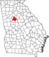
Henry County, Georgia
| Henry County, Georgia | |
|---|---|
 | |
 Location in the U.S. state of Georgia | |
 Georgia's location in the U.S. | |
| Founded | May 15, 1821 |
| Named for | Patrick Henry |
| Seat | McDonough |
| Largest city | Stockbridge |
| Area | |
| • Total | 327 sq mi (847 km2) |
| • Land | 322 sq mi (834 km2) |
| • Water | 4.4 sq mi (11 km2), 1.4% |
| Population (est.) | |
| • (2015) | 217,739 |
| • Density | 633/sq mi (244/km²) |
| Congressional districts | 3rd, 10th, 13th |
| Time zone | Eastern: UTC-5/-4 |
| Website |
www |
Henry County is a county located in the north central portion of the U.S. state of Georgia. Per the 2014 census estimate,[1] the population of Henry County is 213,869. The county seat is McDonough.[2] The county was named for Patrick Henry, Revolutionary War firebrand and champion of individual rights, to whom the slogan "give me liberty, or give me death" is attributed.[3]
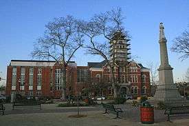
Henry County is part of the Atlanta-Sandy Springs-Roswell, GA Metropolitan Statistical Area. It is home to the Atlanta Motor Speedway in Hampton. The Henry County Courthouse (McDonough, Georgia) is listed on the National Register of Historic Places. In 1995, Henry County was the 6th fastest growing county in the United States.[4]
History
Henry County, Georgia was created by the Georgia State Legislature in 1821 from land acquired from the Creek Indian Nation by the First Treaty of Indian Springs. Henry's original land area was much larger than it is today, stretching from near Indian Springs (present-day Indian Springs State Park) in the south to the Chattahoochee River near Sandy Springs in the north; encompassing most of present-day Metropolitan Atlanta. Before one year passed the size of the County was diminished through the separation of land areas which, in whole or in part, became present day DeKalb, Fulton, Fayette and Newton Counties. Later divisions resulted in Clayton, Spalding, Rockdale and Butts Counties.
In the beginning Henry County was a virgin wilderness, having just been ceded from the Creek Nation. Prior to 1821, the Creeks and a few trappers and traders were the only residents of this area. The Creek Indians left their mark through place names, a few small Indian Mounds scattered around the County and through the arrowheads and broken pottery which can be found throughout Henry County.
Jesse Johnson, son of John Johnson and great-grandfather of U.S. President Lyndon Baines Johnson, was a "first settler" of Henry County. He was a prosperous farmer, sheriff (1822–1835), and judge, before he fled to Alabama.[5]
Geography and transportation
According to the U.S. Census Bureau, the county has a total area of 327 square miles (850 km2), of which 322 square miles (830 km2) is land and 4.4 square miles (11 km2) (1.4%) is water.[6]
The vast majority of Henry County is located in the Upper Ocmulgee River sub-basin of the Altamaha River basin, with just a very small western corner, west of Hampton, located in the Upper Flint River sub-basin of the ACF River Basin (Apalachicola-Chattahoochee-Flint River Basin).[7]
Major highways
-
 Interstate 75
 -
 Interstate 675
 -
 U.S. Route 19
 -
 U.S. Route 23
 -
 U.S. Route 41
 -
 State Route 3
 -
 State Route 20
 -
 State Route 42
 -
 State Route 81
 -
 State Route 138
 -
 State Route 155
 -
 State Route 401 (unsigned designation for I-75)
 -
 State Route 413 (unsigned designation for I-675)
Adjacent counties
- DeKalb County – north
- Rockdale County – northeast
- Newton County – east
- Butts County – southeast
- Spalding County – southwest
- Clayton County – west
Transit systems
- Xpress GA/ RTA Commuter buses serve the county.
Demographics
| Historical population | |||
|---|---|---|---|
| Census | Pop. | %± | |
| 1830 | 10,566 | — | |
| 1840 | 11,756 | 11.3% | |
| 1850 | 14,726 | 25.3% | |
| 1860 | 10,702 | −27.3% | |
| 1870 | 10,102 | −5.6% | |
| 1880 | 14,193 | 40.5% | |
| 1890 | 16,220 | 14.3% | |
| 1900 | 18,602 | 14.7% | |
| 1910 | 19,927 | 7.1% | |
| 1920 | 20,420 | 2.5% | |
| 1930 | 15,924 | −22.0% | |
| 1940 | 15,119 | −5.1% | |
| 1950 | 15,857 | 4.9% | |
| 1960 | 17,619 | 11.1% | |
| 1970 | 23,724 | 34.7% | |
| 1980 | 36,309 | 53.0% | |
| 1990 | 58,741 | 61.8% | |
| 2000 | 119,341 | 103.2% | |
| 2010 | 203,922 | 70.9% | |
| Est. 2015 | 217,739 | [8] | 6.8% |
| U.S. Decennial Census[9] 1790-1960[10] 1900-1990[11] 1990-2000[12] 2010-2013[13] | |||
2000 Census
As of the census[14] of 2000, there were 119,341 people, 41,373 households, and 33,305 families residing in the county. The population density was 370 people per square mile (143/km²). There were 43,166 housing units at an average density of 134 per square mile (52/km²). The racial makeup of the county was 81.38% White, 14.68% Black or African American, 0.23% Native American, 1.76% Asian, 0.04% Pacific Islander, 0.79% from other races, and 1.13% from two or more races. 2.26% of the population were Hispanic or Latino of any race. Census Estimates from the 2008 American Community Survey indicate that the African-American population is 32.6%.
There were 41,373 households out of which 42.90% had children under the age of 18 living with them, 66.40% were married couples living together, 10.30% had a female householder with no husband present, and 19.50% were non-families. 15.40% of all households were made up of individuals and 4.00% had someone living alone who was 65 years of age or older. The average household size was 2.87 and the average family size was 3.19.
In the county the population was spread out with 29.20% under the age of 18, 7.40% from 18 to 24, 34.90% from 25 to 44, 21.00% from 45 to 64, and 7.40% who were 65 years of age or older. The median age was 33 years. For every 100 females there were 97.30 males. For every 100 females age 18 and over, there were 93.80 males.
The median income for a household in the county was $57,309, and the median income for a family was $61,607. Males had a median income of $41,449 versus $29,211 for females. The per capita income for the county was $22,945. About 3.70% of families and 4.90% of the population were below the poverty line, including 5.50% of those under age 18 and 7.80% of those age 65 or over.
2010 census
As of the 2010 United States Census, there were 203,922 people, 70,255 households, and 54,445 families residing in the county.[15] The population density was 633.0 inhabitants per square mile (244.4/km2). There were 76,533 housing units at an average density of 237.6 per square mile (91.7/km2).[16] The racial makeup of the county was 55.0% white, 36.9% black or African American, 2.9% Asian, 0.3% American Indian, 0.1% Pacific islander, 2.4% from other races, and 2.4% from two or more races. Those of Hispanic or Latino origin made up 5.8% of the population.[15] In terms of ancestry, 10.7% were American, 9.3% were Irish, 9.2% were German, and 8.2% were English.[17]
Of the 70,255 households, 45.6% had children under the age of 18 living with them, 55.9% were married couples living together, 16.4% had a female householder with no husband present, 22.5% were non-families, and 18.5% of all households were made up of individuals. The average household size was 2.89 and the average family size was 3.29. The median age was 35.3 years.[15]
The median income for a household in the county was $63,923 and the median income for a family was $70,972. Males had a median income of $50,198 versus $39,785 for females. The per capita income for the county was $25,773. About 6.3% of families and 8.3% of the population were below the poverty line, including 11.7% of those under age 18 and 5.8% of those age 65 or over.[18]
Economy
Goya Foods has its Atlanta offices in an unincorporated area near McDonough.[19]
Media
WKKP AM is the local radio media outlet. It broadcasts 24 hours a day on 1410 AM, and has a classic country format.
The Henry Herald and the Henry County Times are the local county news print media.
Education
Local public schools are run by the Henry County School System.
Elementary schools
- Austin Road Elementary School
- Bethlehem Elementary School
- Cotton Indian Elementary School
- Dutchtown Elementary School
- East Lake Elementary School
- Fairview Elementary School
- Flippen Elementary School
- Hampton Charter Elementary School
- Hickory Flat Charter Elementary School
- Locust Grove Elementary School
- Luella Elementary School
- McDonough Elementary School
- Mt. Carmel Elementary School
- New Hope Elementary School
- Oakland Elementary School
- Ola Elementary School
- Pate's Creek Elementary School
- Pleasant Grove Elementary School
- Red Oak Elementary School
- Rock Spring Elementary School
- Rocky Creek Elementary School
- Smith Barnes Elementary School
- Stockbridge Elementary School
- Timber Ridge Elementary School
- Tussahaw Elementary School
- Union Grove Elementary School
- Walnut Creek Elementary School Home of the Wallabies
- Wesley Lakes Elementary School
- Woodland Elementary School
Middle schools
- Austin Road Middle School
- Dutchtown Middle School
- Eagle's Landing Middle School
- Hampton Middle School
- Henry County Middle School
- Locust Grove Middle School
- Luella Middle School
- Ola Middle School
- Stockbridge Middle School
- Union Grove Middle School
- Woodland Middle School
High schools
Enriched Virtual Program
Alternative schools
- EXCEL Academy
- Mainstay Academy (GNETS - Special Education)
Private schools
- ABC Montessori (Toddler - 12)
- Bible Baptist Christian School (K4–12)
- Community Christian School (Nursery–12)
- Creekside Christian Academy
- Eagle's Landing Christian Academy (K3–12)
- Lake Dow Christian Academy
- New Creation Christian Academy
- North Henry Academy (K3–8)
- Strong Rock Christian School (K–12)
- Peoples Baptist Academy
- Heritage Baptist Christian School
- The Sharon School
Higher education
Mercer University has a Regional Academic Center in McDonough. The center, opened in 2003, offers programs through the university's College of Continuing and Professional Studies and Mercer's Tift College of Education. Clayton State University and Gordon College also offer a range of college courses at the Academy for Advanced Studies in McDonough.
Southern Crescent Technical College's Henry County Center (in McDonough) offers programs in Allied Health, Business Technology, Logistics and Supply Chain Management, Computer Information Systems, Personal Services, Public Safety, and Drafting Technology. [20]
DEVRY UNIVERSITY STOCKBRIDGE CENTER
Located in the Southwest Parkway building, with easy access from Interstate 675 or 75 as well as from Georgia Highway 138, DeVry University Stockbridge Center offers undergraduate and graduate degree programs in some of today's fastest-growing career fields. In close proximity to Fortune 500 corporate headquarters, major financial institutions, and Atlanta's thriving business and high-tech community, DeVry University Stockbridge enables you to explore possible career opportunities in a wide variety of industries.
The Stockbridge Center offers spacious classrooms, a fully wired computer lab, and a comfortable commons area. Once enrolled at the Stockbridge Center, you may also take courses at any Atlanta-area location where the course is offered, or online or in one of our innovative new extended classrooms; our faculty will be there to support you.
Communities
- Blacksville
- Ellenwood (Part)
- Fairview Community
- Flippen
- Hampton
- Kelleytown
- Locust Grove
- Luella
- McDonough
- Ola
- Sandy Ridge[21]
- Stockbridge
See also
References
- ↑ "Henry County QuickFacts from the US Census Bureau". quickfacts.census.gov. Retrieved 2016-02-23.
- ↑ "Find a County". National Association of Counties. Retrieved 2011-06-07.
- ↑ Gannett, Henry (1905). The Origin of Certain Place Names in the United States. Govt. Print. Off. p. 155.
- ↑ "Fastest-growing counties, 1990-95". usatoday30.usatoday.com. Retrieved 2016-02-23.
- ↑ Caro, Robert A. (1983). The Path to Power. The Years of Lyndon Johnson. New York: Alfred A. Knopf. p. 15. ISBN 0394499735. LCCN 90201781.
- ↑ "US Gazetteer files: 2010, 2000, and 1990". United States Census Bureau. 2011-02-12. Retrieved 2011-04-23.
- ↑ "Georgia Soil and Water Conservation Commission Interactive Mapping Experience". Georgia Soil and Water Conservation Commission. Retrieved 2015-11-19.
- ↑ "County Totals Dataset: Population, Population Change and Estimated Components of Population Change: April 1, 2010 to July 1, 2015". Retrieved July 2, 2016.
- ↑ "U.S. Decennial Census". United States Census Bureau. Retrieved June 23, 2014.
- ↑ "Historical Census Browser". University of Virginia Library. Retrieved June 23, 2014.
- ↑ "Population of Counties by Decennial Census: 1900 to 1990". United States Census Bureau. Retrieved June 23, 2014.
- ↑ "Census 2000 PHC-T-4. Ranking Tables for Counties: 1990 and 2000" (PDF). United States Census Bureau. Retrieved June 23, 2014.
- ↑ "State & County QuickFacts". United States Census Bureau. Retrieved June 23, 2014.
- ↑ "American FactFinder". United States Census Bureau. Retrieved 2011-05-14.
- 1 2 3 "DP-1 Profile of General Population and Housing Characteristics: 2010 Demographic Profile Data". United States Census Bureau. Retrieved 2015-12-30.
- ↑ "Population, Housing Units, Area, and Density: 2010 - County". United States Census Bureau. Retrieved 2015-12-30.
- ↑ "DP02 SELECTED SOCIAL CHARACTERISTICS IN THE UNITED STATES – 2006-2010 American Community Survey 5-Year Estimates". United States Census Bureau. Retrieved 2015-12-30.
- ↑ "DP03 SELECTED ECONOMIC CHARACTERISTICS – 2006-2010 American Community Survey 5-Year Estimates". United States Census Bureau. Retrieved 2015-12-30.
- ↑ "Contact Us." Goya Foods. Retrieved on March 26, 2016. "Goya Foods of Atlanta 4005 Haworth Parkway McDonough, GA 30253"
- ↑ https://www.sctech.edu/aboutsctc/locations/henry-county-center/
- ↑ Record of Appointment of Postmasters, 1832-1971. NARA Microfilm Publication, M841, 145 rolls. Records of the Post Office Department, Record Group Number 28. Washington, D.C.: National Archives.
External links
- Henry County Board of Commissioners
- Henry County Chamber of Commerce
- Taste of Henry An annual fundraiser that showcases many of Henry County's best restaurants.
- Kelleytown, GA Website run by Mr. Beau Kelley, a descendant of the original family to which the community is named.
- A Friend's House Henry County's emergency shelter for abused, neglected, and abandoned children.
- Howard, John. "The Sub Series: Henry County, Georgia." Southern Spaces, January 26, 2010.
- Henry County historical marker
 |
Rockdale County and DeKalb County | | ||
| Clayton County | |
Newton County | ||
| ||||
| | ||||
| Spalding County | Butts County |
Municipalities and communities of Henry County, Georgia, United States | ||
|---|---|---|
| Cities | | |
| CDP | ||
| Unincorporated communities | ||
| Footnotes | ‡This populated place also has portions in an adjacent county or counties | |
|  | |||||||
|
| ||||||||
| ||||||||
Template:Georgia
Coordinates: 33°28′N 84°10′W / 33.46°N 84.16°W