Highway 20 (Israel)
| |
|---|---|
|
נתיבי איילון Netivei Ayalon | |
| Ayalon Highway | |
| Route information | |
| Length: | 29 km (18 mi) |
| Major junctions | |
| From: | Rishon LeZion (Holot Interchange) |
| |
| North end: | Herzliya (Begin Interchange) |
| Location | |
| Major cities: | Holon, Herzliya, Bat Yam, Tel Aviv, Givatayim, Ramat Gan |
| Highway system | |
| Highways | |


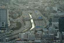
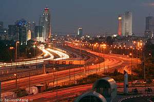
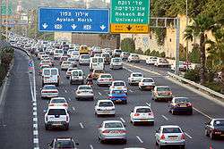


Highway 20, more commonly the Ayalon Highway,[1] or simply Ayalon(Hebrew: נתיבי איילון, pronounced: "Netivei Ayalon", lit. "Ayalon Routes"), is a major intracity freeway in Gush Dan, Israel. The road runs along the eastern border of central Tel Aviv from north to south (with a planned east-west branch as well) and connects all of the major highways leading to the city—such as Highway 4 from Ashdod and the Southern regions, Highway 2 from Haifa and the Northern regions, Highway 5 from the East, and Highway 1 from Jerusalem and the Southeast. The Ayalon Highway is heavily travelled and on an average day almost 600,000 vehicles enter the freeway.[2] It consists of a multi-lane highway with a multi-track railway located between the opposite travel lanes. Some of the highway's route is along the Ayalon River, hence its name.
Background
Before the construction of the Ayalon Highway, all the major inter-city highways leading to Tel Aviv terminated in the outskirts of the city. This created major traffic congestion in the entry and exit points and made driving through the city very difficult. Moreover, before the highway, Tel Aviv had two separate railway stations, one in the north and one in the south, which were not connected. Thus passengers wanting to travel to the South of the country could only do so from the southern station and those who wanted to travel to the North could only do so from the northern (Central) station. Even worse, trains from the northern part of the country could not travel to the southern part of the country without bypassing Tel Aviv from the east, making train travel in Israel very inefficient. Finally there was the problem of the Ayalon River, which went through parts of Tel Aviv and would sometimes cause flooding.
To solve these problems, as early as the 1950s ideas were raised regarding using the route of the river as a transportation corridor, but it wasn't until the mid-1960s that the government began planning. In the 1970s a government-owned company, Ayalon Highways Ltd., was set up to construct the highway. The first phase included construction of a concrete channel for the Ayalon River to alleviate the flooding problem. In 1982, the first section of the road opened, and in 1991 the final section of the central part of the road was completed. This section connects Route 1 in the south with Route 5 and Route 2 in the north. A railway with four stations was built in the center of the highway, which provided for the long-sought connection of Israel's railway network through Tel Aviv.
In the early 1990s the construction of a southern section of the highway had started. This section goes from the HaHagana railway station through the southern Tel Aviv suburbs of Holon, Bat Yam and Rishon LeZion and connects to Highway 4 north of Yavne. After the highway splits with the Ayalon River at Highway 1, it goes on the route of a road called Heyl HaShiryon Road (דרך חיל השריון, "The Armored Corps Road"), then on the route of Yigael Yadin Road until Wolfson Interchange, where it goes on the route of Yigal Allon Road (דרך יגאל אלון).
Impact
The road and railway had a major impact on the Tel Aviv region. While quite congested at times it nevertheless alleviated traveling to and through Tel Aviv. Considerable real estate development of offices, shopping, and housing occurred along the route, so much so, that Tel Aviv's Central Business District lost much of its importance as many businesses relocated to near the road. Israel Railways saw huge increases in passenger numbers now that north/south trains could travel through Tel Aviv instead of around it.
Plans
The southern part of the highway (i.e., the section passing through the Holon, Bat Yam and Rishon LeZion suburbs) was completed in 2012, including a second overpass in the Holon interchange and dual track railroad and 6 stations in the median of the highway (as part of a project which extended the Coastal Railway to Ashdod). An east-west branch "Ayalon East", from Highway 4 to the Tel Aviv University railway station along the path of the Yarkon River has been planned, but is still not approved.[3] Currently the northern terminus of the road is in Herzliya, but is expected to be extended further north to near kibbutz Shefayim, where it will have another connection to Highway 2 by 2018 as part of the Route 531 construction project.
The central section of the road is built along the banks of the Ayalon River. However, Israel railways is in desperate need of adding a fourth railroad track in that area and no space exists to do so but "on top" of the river itself. Several suggestions have been made to solve this problem, ranging from diverting the entire river through Jaffa, to building an elevated highway, to creating a man-made lake for capturing flooding overflow south of the city and burying the river in a large diameter pipe and constructing the railway on top of it. All these solutions involve great cost and no decision has been made yet on how to proceed.
The long-term projection is for Route 20 to run as far north as Hadera. However, this has garnered very strong opposition from environmental groups, since the road would have to cross a nature preserve and other sensitive environmental areas. These groups suggest widening Highway 2 (the so-called "Coastal Highway"), an existing freeway north of Tel Aviv which roughly parallels (several kilometers to the west) Route 20's future route, instead of extending Route 20 northwards.
There is an effort to create a system of bus priority for certain lines that are heavily used and that run through congested areas. This effort is being led by transportation professionals and environmental groups, such as Transport Today and Tomorrow, which seeks to improve sustainable transportation in Israel. Buses are currently subject to the same traffic as cars and creating specific lanes and other forms of prioritization would help to alleviate this problem.
Interchanges
List of interchanges in order from the southernmost at Gan Sorek to the current northern terminus at Menachem Begin St. in Herzliya:
| km | Name | Type | Meaning | Location | Road(s) Crossed |
|---|---|---|---|---|---|
| 0 | מחלף חולות (Holot Interchange) |
|
Sand Dunes | Gan Sorek | |
| 1 | מחלף מבוא איילון (Mevo Ayalon Interchange) |
|
Ayalon Gateway | Rishon LeZion | |
| 3.5 | מחלף משה דיין (Moshe Dayan Interchange) |
|
named after Moshe Dayan |
Rishon LeZion | |
| 5 | מחלף קוממיות (Komemiyut Interchange) |
|
Independence | Bat Yam, Holon |
HaKomemiyut St. |
| 6.5 | מחלף יוספטל (Yoseftal Interchange) |
|
named after Yoseftal |
Bat Yam, Holon |
Yoseftal Blvd. |
| 7.5 | מחלף דב הוז (Dov Hoz Interchange) |
|
named after Dov Hoz |
Holon, Bat Yam |
Dov Hoz Blvd. |
| 9 | מחלף וולפסון (Wolfson Interchange) |
|
Named after nearby Wolfson Medical Center |
Holon, Tel Aviv |
Heinrich Heine St., Ed Koch St., HaRav Heller St., HaLochamim St. |
| 12 | מחלף חולון (Holon Interchange) |
|
named after biblical location[4] (little) sand |
Holon | Levi Eshkol Blvd. |
| 13 | מחלף חיל השריון (Heil HaShiryon) |
|
Armored Corps | Tel Aviv | Hel HaShiryon Blvd. |
| 13 | מחלף קיבוץ גלויות (Kibbutz Galuyot Interchange) |
|
Ingathering of the Exiles |
Tel Aviv | Kibbutz Galuyot St., |
| 14 | מחלף לה גוורדייה (LaGuardia Interchange) |
|
Named after the intersecting LaGuardia Street,[5] which was named in the 1950s for Israel supporter New York mayor Fiorello LaGuardia[6][7] |
Tel Aviv | LaGuardia St. |
| 16 | מחלף השלום (HaShalom Interchange) |
|
(the) Peace | Tel Aviv | HaShalom Road |
| 17 | מחלף ארלוזורוב (Arlozorov Interchange) |
|
Named after Arlozorov |
Tel Aviv | Arlozorov Road, |
| 17.5 | מחלף ההלכה (HaHalakha Interchange) |
|
lit. the way to go | Tel Aviv | HaRav Shlomo Goren St. Bialik St. |
| 19 | מחלף רוקח (Rokah Interchange) |
|
Named after Israel Rokach |
Tel Aviv | Rokah Blvd. |
| 21 | מחלף קרן קיימת (Keren Kayemet Interchange) |
|
National Fund | Tel Aviv | Keren Kayemet LeYisrael Blvd. |
| 23 | מחלף גלילות מזרח (Glilot Mizrah Interchange) |
|
Named after location of former Jewish refugee camp East Glilot |
Ramat HaSharon | |
| 25.5 | מחלף שבעת הכוכבים (Shiv'at HaKohavim Interchange) |
|
The Seven Stars (Herzl's Zionist flag design) |
Herzliya | |
| 27.5 | מחלף המעפילים (HaMa'apilim Interchange) (northbound only) |
|
The Clandestine Immigration | Kfar Shmaryahu | Menachem Begin Blvd. |
| Under construction | |||||
| 29 | (Rishpon Interchange) |
|
Named after nearby moshav Rishpon Village |
Rishpon | |
Railway stations are located nearby the following interchanges (with station name in parenthesis, if differs from interchange name): Shiv'at HaKohavim (Herzliyya), Rokach (University), Arlozorov (Tel Aviv Central), HaShalom, Kibbutz Galuyot (HaHagana), Holon (Holon Junction), Wolfson, Yoseftal, Komemiyut, Moshe Dayan.
References
- ↑ Ayalon Highways, official website \ English
- ↑ "חברת נתיבי איילון בע"מ". Ayalonhw.co.il. Retrieved 2014-02-24.
- ↑ "About the Ayalon East project, from the official website". Ayalonhw.co.il. Retrieved 2014-02-24.
- ↑ Joshua 21:15
- ↑ Travel Israel: An Illustrated Guide, Phrasebook, and Maps, MobiReference, 2007, ISBN 9781605010397, p. PT76 (electronic)
- ↑ Correct street sign spelling of LaGuardia proves elusive, Haaretz (Associated Press), Feb. 15, 2005
- ↑ Judy Shepard & Alvin Rosenfeld, Ticket to Israel: An Informative Guide, Rinehard, 1952, p. 50
External links
| Wikimedia Commons has media related to Highway 20 (Israel). |
- Ayalon Highways Ltd. - Official site. Includes up to the minute traffic reports and live traffic camera views.
- Transport Today and Tomorrow
| Roads |
| ||||||
|---|---|---|---|---|---|---|---|
| Bus operators | |||||||
| Rail transport |
| ||||||
| Sea ports | |||||||
| Aviation |
| ||||||
| Cable cars | |||||||
| By city | |||||||
| Smart cards | |||||||
Coordinates: 32°02′15″N 34°45′52″E / 32.03750°N 34.76444°E