Route 417 (Israel)
| |
|---|---|
|
כביש 417 Kvish Arba-Ahat-Sheva | |
 | |
| Route information | |
| Length: | 16 km (10 mi) |
| Major junctions | |
| West end: |
|
| East end: |
|
| Location | |
| Major cities: |
|
| Highway system | |
| Highways | |
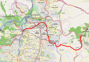
Route 417 (Hebrew: כביש 417, "Kvish Arba'-Achat-Sheva'") is an intercity road in Israel and the West Bank that stretches from the west side of Jerusalem to Ma'ale Adumim and Highway 1 east to the Jordan Valley.
History
Most of the road serves as a local thoroughfare within Jerusalem and East Jerusalem. The road has been non-contiguous since the construction of the Israeli West Bank barrier through Abu Dis in 2006.[1] Route 417 used to be the main route from the west to the Jordan Valley and the Dead Sea, bypassing downtown Jerusalem. With the opening of Jerusalem Road 9 (Derech Yitzhak Shamir and Yigal Yadin Boulevard) and the Ma'ale Adumim Road, the historic route lost that distinction. With the closure of the road in Abu Dis, the route no longer serves that option at all.
Route
The route's name changes many times along the way. From west to east:
Yirmiyahu Street
Named after the biblical prophet,[2] the route begins at Weizmann Boulevard at the base of the Strings Bridge, an area known historically as the western "Jerusalem Gate", the main entrance to the city from the west. It passes the beginning of Jaffa Road near the Jerusalem Central Bus Station and the headquarters of Magen David Adom. It then winds through the Romema neighborhood as a commercial and light-industrial four-lane divided boulevard.
Bar-Ilan Street
Just past the Shikun Chabad neighborhood, the well-known Bar-Ilan St. named after Rabbi Meir Berlin, passes between the Haredi neighborhoods of Tel Arza, Mahanayim and Bukharim. Here the road serves as a major shopping street. In many sections, fencing exists on the median divider to prevent pedestrians from crossing between controlled intersections on this heavily congested section. Before 1955, this was called "The Ring Road", skirting around the northern edge of what was then the built-up area of central Jerusalem.[2]
Hativat HarEl Street
Named after the famous Harel Brigade,[2] this 0.3 km section widens into a 6-lane divided boulevard between the Sanhedria and Shmuel HaNavi neighborhoods.
Levi Eshkol Boulevard
This section, built in 1968, was named after Israel's third prime minister.[2] The route continues past the Ma'alot Dafna, Ramat Eshkol and Givat HaMivtar neighborhhoods. Just short of Haim Bar-Lev Boulevard (Highway 60), also known as Jerusalem Road 1, a 0.2 km tunnel provides an alternate route bypassing the congested traffic-light controlled intersection which includes a crossing of the Jerusalem Light Rail tracks.
Hebrew University Boulevard
This 0.6 km stretch passes Kiryat Menachem Begin, the Dan Jerusalem Hotel (formerly the Hyatt Regency) and the main entrance road to the Hebrew University's Har HaTsofim campus.
Wadi al-Joz Street
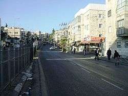
While most traffic continues straight through the new Har HaTzofim tunnels bypassing East Jerusalem's built-up areas and connecting to Highway 1 to Ma'ale Adumim and the Dead Sea, the official Route 417 makes a right turn southward onto Wadi al-Joz St. Here, in the Wadi al-Joz neighborhood, named after the "Walnut Valley",[2] the street serves as a main commercial artery. This section of the road contains many auto-repair shops giving it the nickname among Hebrew speakers of 'Wadi Egzōz' (i.e., exhaust).
al-Maqdesi Street
Continuing southward as a commercial street, this 0.4 km stretch, named after the famous 10th-century Arab geographer,[2] passes the Failey Center for the Arts and the Rockefeller Museum as it approaches the northeast corner of Jerusalem's Old City.
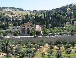
traditional site of Gethsemane with
Church of All Nations (center) and
Church of Maria Magdalene (upper right)
Jericho Road
Along the eastern edge of the Old City, the now named Jericho Road descends into the Kidron Valley, also known by its biblical name, the Valley of Josaphat.[3] The valley is the site of many tombs: the Tomb of the Blessed Virgin Mary, the Pillar of Absalom, the Tomb of Benei Hezir, the Tomb of Zechariah, the tomb of Josaphat and the tomb of Saint James.
The road then runs along the bottom of the Mount of Olives and continues through the Ras al-Amud, Ma'ale ha-Zeitim and Wadi Qadum neighborhoods as a commercial street.
At ash-Shiyah Street at the edge of Abu Dis, the Israeli West Bank barrier has been erected. Originally including a security checkpoint, the road was permanently closed in 2006. Past the barrier, the road continues as a commercial artery through Abu Dis, al-Eizariya and Jahalin.
As it passes Ma'ale Adumim, the route becomes a freeway, finally merging into Highway 1 to the Jordan Valley.
Junctions (west to east)
| km | Location | Name | Type | Meaning | Road(s) Crossed |
|---|---|---|---|---|---|
| ↓Jerusalem Municipality↓ | |||||
| Yirmiyahu Street | |||||
| 0 | Romema | |
Weizmann Blvd. Strings Bridge | ||
| 0.05 | Romema | |
Jaffa Road | ||
| 0.1 | Romema | |
Ha Mem Gimel St. | ||
| 0.2 | Romema | |
Aholiab St.,[4] HaTvi St. | ||
| 0.3 | Romema | |
HaRikma St.[5] | ||
| 0.4 | Romema | |
HaRikma St. | ||
| 0.5 | Romema | |
Tuval St.[6] HaTchelet St. | ||
| 0.6 | Romema | |
HaTchelet St. | ||
| 0.7 | Romema | |
Argaman St.[7] | ||
| 1 | Romema | |
Tuval St. | ||
| 1.1 | Romema | |
Shamgar St.[8] | ||
| 1.2 | Romema | ככר לוין (Rabbi Levin Square) |
|
named after Rabbi Pinhas Ya'akov HaCohen Levin |
Minhat Yitzhak St. |
| 1.6 | Shikun Chabad | ככר הרב עזריאל זעליג סלונים (Rabbi Azriel Zelig Slonim Square) |
|
named after Rabbi Avriel Zelig Slonim |
Elkana St.[9] |
| 1.7 | Tel Arza, Bukharim | ככר הרב אברמסקי (Rabbi Abramsky Square) |
|
named after Rabbi Yehezkel Abramsky |
Eli HaCohen St.[10] Tsfanya St. |
| Bar-Ilan Street | |||||
| 1.73 | Tel Arza, Bukharim | eastbound only | |
Issa Bracha St. | |
| 1.76 | Tel Arza, Bukharim | |
Yosef Ziv St., HaBucharim St. | ||
| 1.82 | Tel Arza, Bukharim | |
Adoniyahu HaCohen St. | ||
| 1.87 | Mahanayim, Bukharim | |
Hacham Shmuel Bruchim St., Ki Tov St. | ||
| 1.89 | Mahanayim, Bukharim | |
Rabeinu Gershom St. | ||
| 1.93 | Mahanayim, Bukharim | westbound only | |
HaGaon MiTurda St. | |
| 1.96 | Mahanayim, Bukharim | |
Ohalei Yosef St., Evyatar HaCohen St.[11] | ||
| 2.08 | Mahanayim, Bukharim | eastbound only | |
Avinadav St.[12] | |
| 2.2 | Mahanayim, Bukharim, Sanhedriya, Shmuel HaNavi |
ככר בית החיים (Beit HaHayyim Square) |
|
House of Life (name of adjacent municipal Funeral Home) |
(Shmuel HaNavi St.)[13] |
| Hativat HarEl Street | |||||
| 2.4 | Sanhedriya, Shmuel HaNavi | |
Etz Hadar St. | ||
| 2.6 | Sanhedriya, Shmuel HaNavi | |
Eretz Hefetz St. | ||
| Levi Eshkol Boulevard | |||||
| 2.65 | Ramat Eshkol, Ma'alot Dafna |
westbound only | |
Mikvei Yisrael St. | |
| 2.7 | Ramat Eshkol, Ma'alot Dafna |
|
Mismar HaGvul St. | ||
| 2.8 | Green Line | ||||
| 2.9 | Ramat Eshkol, Ma'alot Dafna |
|
Ma'avar HaMitla St., Ya'akov (Carl) Netter St. | ||
| 3.5 | Ramat Eshkol, Givat HaMivtar |
|
Sheshet HaYammim St. | ||
| 3.6 | Givat HaMivtar, Givat HaTahmoshet, Kiryat Menachem Begin, HaGiv'a HaTzarfatit |
ככר מיינרצהאגן (Meinertzhagen Square) |
|
named after Richard Meinertzhagen |
(Haim Bar-Lev Blvd.) Jerusalem Light Rail Station |
| Hebrew University Blvd. | |||||
| 4.1 | Kiryat Menachem Begin, Har HaTsofim |
|
Aharon Katzir St. | ||
| 4.2 | Wadi al-Joz, Har HaTsofim |
|
Shayeret HaTzofim Blvd., Yitzhak HaNadiv St. (to Har HaTsofim Tunnels) | ||
| Wadi Al-Joz Street | |||||
| 4.3 | Wadi Al-Joz | |
Beni Ummayya St. | ||
| 4.5 | Wadi Al-Joz | |
Abu Bakir as-Sideeq St. | ||
| 4.8 | Wadi Al-Joz | |
Ibn Tulun St. | ||
| 4.9 | Wadi Al-Joz | |
Uthman ibn Affan St. | ||
| 5 | Wadi Al-Joz | |
Khalid ibn al-Walid St. | ||
| 5.1 | Wadi al-Joz | |
al-Maqdesi Street St. | ||
| al-Maqdesi Street | |||||
| 5.2 | Wadi al-Joz | |
Abu Hanifa St. | ||
| 5.3 | Wadi al-Joz | |
Akhwan as-Saffa St. | ||
| 5.5 | Wadi al-Joz | |
al-Akhtal St. | ||
| 5.6 | Old City Wadi al-Joz Al-Sawaneh |
|
Sultan Suleiman St., Samaw'al ibn 'Adiya St. (At-Tur Road) | ||
| Jericho Road | |||||
| 6.4 | Old City | |
Lions' Gate Road | ||
| 6.5 | Old City | |
Ophel Road | ||
| 6.6 | Har HaZeitim | |
al-Mansuriya St. | ||
| 7.2 | Ras al-Amud Ma'ale ha-Zeitim Har HaZeitim |
|
local street | ||
| 7.3 | Ras al-Amud Ma'ale ha-Zeitim |
|
local street | ||
| 7.5 | Har HaZeitim | |
local street | ||
| 7.7 | Ras al-Amud | |
Ras al-Amud St | ||
| 7.8 | Ras al-Amud | |
local street | ||
| 8.2 | Wadi Qadum | |
Wadi Abdallah St. | ||
| 8.25 | Wadi Qadum | |
local street | ||
| 8.3 | Wadi Qadum | |
local street | ||
| 9 | Abu Dis | Ras al-Qubsa Junction | |
ash-Shiyah St. | |
| ↑Jerusalem Municipality↑ | |||||
| | |||||
| 9 | | ||||
| | |||||
| 9.5 | Abu Dis | |
12 local streets | ||
| 10.3 | Abu Dis, al-Eizariya | |
local street | ||
| 10.9 | al-Eizariya | |
19 local streets | ||
| 12.2 | Jahalin | |
5 local streets | ||
| 12.5 | Jahalin | |
local street | ||
| 12.6 | Jahalin | |
2 local streets | ||
| | |||||
| 13.7 | Kedar | |
Kedar Road | ||
| 13.8 | Ma'ale Adumim | צומת מעלה אדומים (Ma'ale Adumim Junction) |
|
Derech Har HaBayit | |
| 16 | Ma'ale Adumim | מחלף אדומים (Adumim Interchange) |
|
Red (Ascent) | Highway 1 |
See also
References
- ↑ Ruth Lapidot, et al., Amnon Ramon, ed. (2007). "The Historic Basin of Jerusalem - Problems and possible solutions" (PDF). Jerusalem Institute for Israel Studies. p. 27. Retrieved 2012-01-28.
- 1 2 3 4 5 6 "Information about Jerusalem Street Names". Jerusalem Municipality. Retrieved 2012-02-03.(Hebrew)
- ↑ Joel 4:2
- ↑ Exodus 31:6
- ↑ Ezekiel 16:10
- ↑ Genesis 4:22
- ↑ Exodus 26:1 and following
- ↑ Judges 3:31
- ↑ 1Samuel 1:1
- ↑ 1Samuel 1:9
- ↑ 1Kings 1:7
- ↑ 1Samuel 31:2
- ↑ 1Samuel 1:20
Coordinates: 31°46′56.05″N 35°14′20.04″E / 31.7822361°N 35.2389000°E
| Roads |
| ||||||
|---|---|---|---|---|---|---|---|
| Bus operators | |||||||
| Rail transport |
| ||||||
| Sea ports | |||||||
| Aviation |
| ||||||
| Cable cars | |||||||
| By city | |||||||
| Smart cards | |||||||