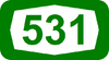
Route 531 (Israel)
| |
|---|---|
| 531 כביש | |
 | |
| Route information | |
| Length: |
7.2 km (4.5 mi) 15.2 km (9.4 mi) upon completion of western extension |
| Major junctions | |
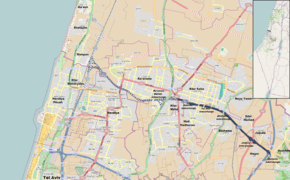
| West end: | Kfar Malal Junction |
| |
| East end: | Horshim Interchange |
| Location | |
| Major cities: | (Rishpon), (Kfar Shmaryahu), (Herzliya), Ra'anana, Kfar Malal, Kfar Saba, Elishama, Jaljulia, Horshim |
| Highway system | |
| Highways | |

Route 531 (Hebrew: כביש 531), is a suburban freeway in the southern Sharon region of Israel, just north of the Tel Aviv Metropolitan Area.
Herzliya–Ra'anana extension
The highway currently begins at Kfar Malal and Kfar Saba and terminates at Highway 6. In 2008 a PFI tender was issued to continue constructing the highway westward towards Highway 20 (Ayalon Highway) near the Mediterranean coast. By doing so it will pass nearby several large cities and connect all the major north-south highways in the region: Highway 6, Highway 4 and Highway 20. The project also includes extending Highway 20 several kilometers northwards, connecting it and Route 531 to Highway 2 (the Coastal Highway) heading northbound at a new interchange near Ga'ash.[1]
In addition, the project includes constructing a dual-track railway including a long railway tunnel and several passenger stations in the median of the highway along nearly the entire length of the road (using a design similar to the recently completed Route 431 suburban freeway). The new railway will connect the existing Hod HaSharon Railway Station to the Coastal Railway.
Shapir Engineering won the tender to extend the road and railway, but due to financial disagreements and complications caused by the worldwide financial crisis, the government canceled the PFI tender in the summer of 2010. Instead, the project will be funded directly by the treasury and managed by the National Roads Company and be split off to several sections, each of which will be tendered separately at an estimated total cost of NIS 4 billion (equivalent to slightly over US$1 billion), a move which will postpone completion by four years, to late 2016.[2]
Interchanges & Junctions
| km | Name | Type | Meaning | Location | Road(s) Crossed |
|---|---|---|---|---|---|
| Under Construction (Completion: 2016)[3][4][5][6] | |||||
| (0) | מחלף Interchange |
|
Rishpon, Kfar Shmaryahu, Herzliya |
to | |
| 0 (3.9) | מחלף הרצליה מזרח Herzliya Mizrach Interchange |
|
East Herzliya | Ra'anana, Herzliya |
(Derech Yerushalayim) |
| (5.6) | מחלף ח"ן Chen Interchange |
|
Abbreviation of Hayim Nahman Bialik |
Ra'anana | Ben Gurion St. |
| (7.1) | מחלף רעננה דרום (Ra'anana Darom Interchange) |
|
Ra'anana South | Ra'anana, Kfar Malal |
(Tchernichovsky St.) |
| 4.1 (8) | צומת מל"ל Malal Junction |
|
Named after Moshe Leib Lilienblum |
Kfar Malal, Kfar Saba |
(HaSharon St.) (Ein Hai St.) |
| 4.8 (8.7) | מחלף סוקולוב Sokolov Interchange |
|
Named after Nahum Sokolow |
Kfar Saba | Sokolov St. |
| 5.9 (9.8) | מחלף תל חי Tel Hai Interchange |
|
Hill of Life | Kfar Saba, Hod HaSharon |
Tel Hai St., Shazar St. |
| 7.3 (11.2) | מחלף אלישמע Elishama Interchange |
|
ult. named after Elishama, son of Ammihud |
Kfar Saba, Elishama |
|
| 9.9 (13.8) | מחלף ג'לג'וליה Jaljulia Interchange |
|
Named after location | Jaljulia, Hagor, Horshim |
to |
| 11.3 (15.2) | מחלף חורשים Horshim Interchange |
|
Ploughmen | Horshim | |
References
- ↑ "Last Two Tenders for Route 531 Published". Port2Port. 2012-02-09. Retrieved 2013-07-11.(Hebrew)
- ↑ Avi Bar-Eli (2011-01-16). "A Year After the PFI Tender was Canceled — Route 531 Project Resumes". TheMarker. Retrieved 2011-01-16.(Hebrew)
- ↑ "Route 531 - Between Route 402 and Highway 20". National Roads Company of Israel. Retrieved 2013-01-29.(Hebrew)
- ↑ "Ashtrom is the winner of the tender". National Roads Company of Israel. Retrieved 2013-01-29.(Hebrew)
- ↑ "Construction of new route 531". Israel Ministry of Transport, National Infrastructure & Road Safety. Retrieved 2013-01-29.(Hebrew)
- ↑ http://www.globes.co.il/en/article-new-road-relieves-raanana-traffic-jams-1001095583
| Roads |
| ||||||
|---|---|---|---|---|---|---|---|
| Bus operators | |||||||
| Rail transport |
| ||||||
| Sea ports | |||||||
| Aviation |
| ||||||
| Cable cars | |||||||
| By city | |||||||
| Smart cards | |||||||
Coordinates: 32°10′6.18″N 34°54′35.54″E / 32.1683833°N 34.9098722°E