Arkansas Highway 90
| ||||
|---|---|---|---|---|
 | ||||
| Route information | ||||
| Maintained by AHTD | ||||
| Length: | 81.93 mi[1] (131.85 km) | |||
| Existed: | 1926 – present | |||
| Major junctions | ||||
| West end: | Main Street, Ravenden | |||
|
| ||||
| East end: |
| |||
| Location | ||||
| Counties: | Lawrence, Randolph, Greene, Clay | |||
| Highway system | ||||
| ||||

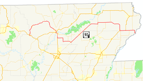
Arkansas Highway 90 (AR 90, Ark. 90, and Hwy. 90) is an east–west state highway in northeast Arkansas. The route of 81.93 miles (131.85 km) runs from Main Street in Ravenden to Route 84 at the Missouri state line.[2] The route is an entirely undivided surface highway that passes through rich cotton country.[3][4][5][6]
Route description
AR 90 begins at Main Street in Ravenden and heads north to cross US 62/US 63/US 412. The route winds to Pocahontas where it meets AR 115 and US 62/US 67/AR 166. US 67/AR 90 run together south to Shannon. AR 90 then turns east to meet AR 231 and AR 34 in O'Kean. The route runs diagonally northeast until meeting AR 135 east of Knobel.
The route runs east to meet AR 141 near Boydsville and US 49/AR 1 in Rector. AR 90 continues west to terminate at Route 84 at the St. Francis River on the Missouri state line.
Major intersections
Mile markers reset at concurrencies.[c 1]
| County | Location | mi[1] | km | Destinations | Notes |
|---|---|---|---|---|---|
| Lawrence | Ravenden | 0.00 | 0.00 | Main Street | Western terminus |
| 0.40 | 0.64 | ||||
| Randolph | | 15.22 | 24.49 | ||
| Pocahontas | 25.38 | 40.85 | |||
| 26.47 | 42.60 | ||||
| | |||||
| | |||||
| Shannon | 0.00 | 0.00 | |||
| | 8.75 | 14.08 | |||
| O'Kean | 10.69 | 17.20 | |||
| Greene | Delaplaine | 17.50 | 28.16 | ||
| | 18.24 | 29.35 | |||
| Clay | Peach Orchard | 22.25 | 35.81 | ||
| | 31.18 | 50.18 | |||
| | |||||
| | 0.00 | 0.00 | |||
| Tipperary | 4.52 | 7.27 | |||
| Boydsville | 7.85 | 12.63 | |||
| Rector | 17.06 | 27.46 | |||
| | |||||
| Hargrave Corner | 0.00 | 0.00 | |||
| | 2.06 | 3.32 | |||
| Holly Island | 4.05 | 6.52 | |||
| Arkansas–Missouri state line | 7.22 | 11.62 | |||
1.000 mi = 1.609 km; 1.000 km = 0.621 mi
| |||||
Notes
- ↑ Although Arkansas highways normally terminate when intersected by a route of greater importance, Highway 90 in Randolph County does not end when intersecting Highway 34 in O'Kean.[7]
References
- 1 2 Planning and Research Division (2010). "Arkansas Road Log Database". Arkansas State Highway and Transportation Department. Archived from the original (Database) on 23 June 2011. Retrieved June 9, 2011.
- ↑ Map of Ravenden, Lawrence County, Arkansas (PDF) (Map) (April 2009 ed.). Arkansas State Highway and Transportation Department, Planning and Research Division. Retrieved August 21, 2011.
- ↑ Arkansas State Highway and Transportation Department. AHTD Lawrence County map Retrieved on August 21, 2009.
- ↑ Arkansas State Highway and Transportation Department. AHTD Randolph County map Retrieved on August 21, 2009.
- ↑ Arkansas State Highway and Transportation Department. AHTD Greene County map Retrieved on August 21, 2009.
- ↑ Arkansas State Highway and Transportation Department. AHTD Clay County map Retrieved on August 21, 2009.
- ↑ Route and Section Map (PDF) (Map) (Randolph County ed.). Arkansas State Highway and Transportation Department. Retrieved August 21, 2011.