Randolph County, Arkansas
| Randolph County, Arkansas | |
|---|---|
 Randolph County courthouse in Pocahontas | |
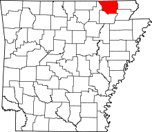 Location in the U.S. state of Arkansas | |
 Arkansas's location in the U.S. | |
| Founded | October 29, 1835 |
| Named for | John Randolph |
| Seat | Pocahontas |
| Largest city | Pocahontas |
| Area | |
| • Total | 656 sq mi (1,699 km2) |
| • Land | 652 sq mi (1,689 km2) |
| • Water | 3.8 sq mi (10 km2), 0.6% |
| Population (est.) | |
| • (2015) | 17,469 |
| • Density | 28/sq mi (11/km²) |
| Congressional district | 1st |
| Time zone | Central: UTC-6/-5 |
Randolph County is a county located in the U.S. state of Arkansas. As of the 2010 census, the population was 17,969.[1] The county seat is Pocahontas.[2] Randolph County is Arkansas's 32nd county, formed on October 29, 1835, and named for John Randolph, a U.S. senator from Virginia, who was influential in obtaining congressional approval of the Louisiana Purchase, of which Randolph County is a part.
Randolph County is currently an alcohol prohibition or dry county.
Geography
According to the U.S. Census Bureau, the county has a total area of 656 square miles (1,700 km2), of which 652 square miles (1,690 km2) is land and 3.8 square miles (9.8 km2) (0.6%) is water.[3]
Major highways
Adjacent counties
- Oregon County, Missouri (northwest)
- Ripley County, Missouri (northeast)
- Clay County (east)
- Greene County (southeast)
- Lawrence County (south)
- Sharp County (west)
Demographics
| Historical population | |||
|---|---|---|---|
| Census | Pop. | %± | |
| 1840 | 2,196 | — | |
| 1850 | 3,275 | 49.1% | |
| 1860 | 6,261 | 91.2% | |
| 1870 | 7,466 | 19.2% | |
| 1880 | 11,724 | 57.0% | |
| 1890 | 14,485 | 23.5% | |
| 1900 | 17,156 | 18.4% | |
| 1910 | 18,987 | 10.7% | |
| 1920 | 17,713 | −6.7% | |
| 1930 | 16,871 | −4.8% | |
| 1940 | 18,319 | 8.6% | |
| 1950 | 15,982 | −12.8% | |
| 1960 | 12,520 | −21.7% | |
| 1970 | 12,645 | 1.0% | |
| 1980 | 16,834 | 33.1% | |
| 1990 | 16,558 | −1.6% | |
| 2000 | 18,195 | 9.9% | |
| 2010 | 17,969 | −1.2% | |
| Est. 2015 | 17,469 | [4] | −2.8% |
| U.S. Decennial Census[5] 1790–1960[6] 1900–1990[7] 1990–2000[8] 2010–2015[1] | |||
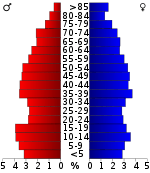
As of the 2000 United States Census,[10] there were 18,195 people, 7,265 households, and 5,245 families residing in the county. The population density was 28 people per square mile (11/km²). There were 8,268 housing units at an average density of 13 per square mile (5/km²). The racial makeup of the county was 96.99% White, 0.97% Black or African American, 0.53% Native American, 0.07% Asian, 0.01% Pacific Islander, 0.27% from other races, and 1.15% from two or more races. 0.82% of the population were Hispanic or Latino of any race.
There were 7,265 households out of which 30.70% had children under the age of 18 living with them, 58.40% were married couples living together, 9.90% had a female householder with no husband present, and 27.80% were non-families. 24.70% of all households were made up of individuals and 12.10% had someone living alone who was 65 years of age or older. The average household size was 2.46 and the average family size was 2.93.
In the county the population was spread out with 24.60% under the age of 18, 8.30% from 18 to 24, 25.70% from 25 to 44, 24.30% from 45 to 64, and 17.00% who were 65 years of age or older. The median age was 39 years. For every 100 females there were 96.00 males. For every 100 females age 18 and over, there were 90.50 males.
The median income for a household in the county was $27,583, and the median income for a family was $33,535. Males had a median income of $25,006 versus $18,182 for females. The per capita income for the county was $14,502. About 11.90% of families and 15.30% of the population were below the poverty line, including 18.80% of those under age 18 and 15.20% of those age 65 or over.
Communities
City
- Pocahontas (county seat)
Towns
Townships
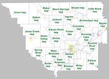
Townships in Arkansas are the divisions of a county. Each township includes unincorporated areas; some may have incorporated cities or towns within part of their boundaries. Arkansas townships have limited purposes in modern times. However, the United States Census does list Arkansas population based on townships (sometimes referred to as "county subdivisions" or "minor civil divisions"). Townships are also of value for historical purposes in terms of genealogical research. Each town or city is within one or more townships in an Arkansas county based on census maps and publications. The townships of Randolph County are listed below; listed in parentheses are the cities, towns, and/or census-designated places that are fully or partially inside the township. [11][12]
- Baker
- Bristow
- Butler
- Columbia
- Current River (Biggers)
- Dalton
- Demun (Pocahontas)
- East Roanoke
- Eleven Point
- Foster
- Ingram
- Jackson
- Janes Creek (Ravenden Springs)
- Little Black
- O'Kean (O'Kean)
- Reyno (Reyno)
- Richardson (Maynard)
- Running Lake
- Shiloh
- Siloam
- Spring River
- Union
- Warm Springs
- Water Valley
- West Roanoke
- Wiley
Notable people
- William Jasper Blackburn, a Reconstruction U.S. Representative from Louisiana
- Edwin R. Bethune, U.S. Representative from Arkansas
- Drew Bowers, the Republican nominee for governor of Arkansas in 1926 and 1928
- Thomas S. Drew, Third Governor of Arkansas
- Rufe Persful, Notorious 1930s hoodlum who, while a prisoner in Alcatraz, cut off his left hand with a fire axe in an effort to get transferred from "The Rock"
- John R. Kizer, Randolph County's first county agent and suspected serial killer responsible for the death's of ten people including two of his wives and his adopted son.
- Joseph J. Alexander, Randolph County's first representative at Arkansas' first State Assembly after becoming a state. He was killed 4 Dec 1837 by the Speaker of the House, John Wilson, during a knife fight on the floor of the assembly chamber.
- A. Manley Jackson, Pocahontas Marshall, who was killed in the line of duty 8 Nov 1931 by Freddie Barker of the notorious "Ma" Barker-Karpus Gang.
- John Z. Norris, Town Marshall of Pocahontas, who was killed in the line of duty 21 Mar 1901 by George Chevrie who was later lynched, the second man to be lynched in Randolph County
- George Nicholas 'Nick' Wilson (1942 - ) former Arkansas lawyer and political leader who served in the Arkansas Senate for almost 30 years..
- George William Baltz (1888 - 1979) inventor of The Wonder Horse.
See also
References
- 1 2 "State & County QuickFacts". United States Census Bureau. Retrieved May 24, 2014.
- ↑ "Find a County". National Association of Counties. Archived from the original on 2011-05-31. Retrieved 2011-06-07.
- ↑ "2010 Census Gazetteer Files". United States Census Bureau. August 22, 2012. Retrieved August 27, 2015.
- ↑ "County Totals Dataset: Population, Population Change and Estimated Components of Population Change: April 1, 2010 to July 1, 2015". Retrieved July 2, 2016.
- ↑ "U.S. Decennial Census". United States Census Bureau. Archived from the original on May 11, 2015. Retrieved August 27, 2015.
- ↑ "Historical Census Browser". University of Virginia Library. Retrieved August 27, 2015.
- ↑ Forstall, Richard L., ed. (March 27, 1995). "Population of Counties by Decennial Census: 1900 to 1990". United States Census Bureau. Retrieved August 27, 2015.
- ↑ "Census 2000 PHC-T-4. Ranking Tables for Counties: 1990 and 2000" (PDF). United States Census Bureau. April 2, 2001. Retrieved August 27, 2015.
- ↑ Based on 2000 census data
- ↑ "American FactFinder". United States Census Bureau. Archived from the original on 2013-09-11. Retrieved 2011-05-14.
- ↑ 2011 Boundary and Annexation Survey (BAS): Randolph County, AR (PDF) (Map). U. S. Census Bureau. Retrieved 2011-08-07.
- ↑ "Arkansas: 2010 Census Block Maps - County Subdivision". United States Census Bureau. Retrieved May 29, 2014.
External links
- Cemeteries of Randolph County
- Randolph County Chamber of Commerce
- Randolph County Tourism Association
- Randolph County Sheriff's Office
 |
Oregon County, Missouri | Ripley County, Missouri | | |
| Sharp County | |
Clay County | ||
| ||||
| | ||||
| Lawrence County | Greene County |
Municipalities and communities of Randolph County, Arkansas, United States | ||
|---|---|---|
| Cities | | |
| Towns | ||
| Unincorporated communities | ||
Coordinates: 36°20′41″N 91°00′46″W / 36.34472°N 91.01278°W