Jamaica Center–Parsons/Archer (Archer Avenue Lines)
| Jamaica Center–Parsons/Archer | |||||||||
|---|---|---|---|---|---|---|---|---|---|
| New York City Subway rapid transit station | |||||||||
|
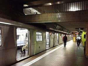
Upper level platform | |||||||||
| Station statistics | |||||||||
| Address |
Parsons Boulevard & Archer Avenue Queens, NY 11433 | ||||||||
| Borough | Queens | ||||||||
| Locale | Jamaica | ||||||||
| Coordinates | 40°42′09″N 73°48′00″W / 40.702407°N 73.799973°WCoordinates: 40°42′09″N 73°48′00″W / 40.702407°N 73.799973°W | ||||||||
| Division | B (BMT/IND) | ||||||||
| Line |
BMT Archer Avenue Line (lower level) IND Archer Avenue Line (upper level) | ||||||||
| Services |
E J Z | ||||||||
| Transit connections |
(all at Jamaica Center Bus Terminal) | ||||||||
| Structure | Underground | ||||||||
| Levels | 2 | ||||||||
| Platforms | 2 island platforms (1 on each level) | ||||||||
| Tracks | 4 (2 on each level) | ||||||||
| Other information | |||||||||
| Opened | December 11, 1988 | ||||||||
| Accessible |
| ||||||||
| Wireless service |
| ||||||||
| Traffic | |||||||||
| Passengers (2015) |
12,622,977[3] | ||||||||
| Rank | 26 out of 422 | ||||||||
| Station succession | |||||||||
|
| |||||||||
| Next |
(Terminal): E | ||||||||
| Next |
Sutphin Boulevard–Archer Avenue–JFK Airport: E | ||||||||
| |||||||||
| |||||||||


Jamaica Center–Parsons/Archer (formerly Jamaica Center–Parsons Boulevard) is the northern terminal station of the IND and BMT Archer Avenue Lines of the New York City Subway, located at Parsons Boulevard and Archer Avenue in Jamaica, Queens. It is a major transfer point for buses from eastern Queens, and replaces the old 160th Street Station of the BMT Jamaica Line, and inadvertently the former Union Hall Street Long Island Rail Road station. This station opened on December 11, 1988.
Station layout
| G | Street Level | Exit/ Entrance |
| B1 | Mezzanine | Fare control, station agents |
| B2 Upper level |
Southbound | ← |
| Island platform, doors will open on the left or right | ||
| Southbound | ← | |
| B3 Lower level |
Southbound | ← |
| Island platform, doors will open on the left or right | ||
| Southbound | ← | |
This is a two-level station with E trains serving the upper level (IND) at all times, and the J and Z trains serving the lower level (BMT), the former of which operates all times and the latter of which operates during rush hours in the peak direction. Each level has two tracks and one island platform. Both platforms are 600 feet (183 m) in length, standard for a full-length B Division train; however, since BMT Eastern Division trains are only 480 feet (146 m) long, there are fences at both of the unused ends of the lower-level platforms to prevent passengers from falling onto the tracks.
This station has tan brick walls and red brick floor on both levels; the ceilings have metal slats and resembles a vaulted ceiling, except there are no curves.
Entrances and exits
.jpg)
There are two entrances to this station.
-
 Exit 1: The first one is at the very north end of the platforms. It contains a mezzanine that has four escalators, two to each platform, and an ADA-accessible elevator serving both platforms. There is a large, single bank of turnstiles leading to fare control. One wide staircase and one escalator leads to a pavilion behind the streets at the northeast corner of Parsons Boulevard and Archer Avenue. A narrower staircase and escalator leads to the southeast corner. An elevator is present as well. This entrance contains a 1991 artwork called Jamaica Center Station Riders by Sam Gilliam made up of blue painted aluminum.[4]
 - Exit 2: The second exit is near the middle of the platforms. Each platform contains two escalators to the mezzanine. The upper level also has one staircase to the mezzanine while the lower level has two. In this mezzanine there is more overlap of walls between fare control and the portion of the mezzanine for the station exits. In addition to the part-time bank of standard turnstiles, there are HEET turnstiles to provide access during off-peak hours. This entrance has three street stairs. Two of them, one of which also has an up-only escalator, lead up to the south side of Archer Avenue outside the bus boarding area. The staircase with the escalator has a brickwork design surrounding it while the other staircase at this entrance has an ultra-wide green metal fence. There is another staircase, the narrowest in the entire station at the northeast corner of Archer Avenue and 153rd Street.[4]
Infrastructure
West of the station, both levels feature diamond crossovers. The upper level's crossover is just west of the platform, while the lower level's is halfway between this station and Sutphin Boulevard–Archer Avenue.[5]
The tracks on both levels extend past the station for possible future extensions, but are currently used for storage.[6][7] On the lower level, they continue one train length of about 480 feet (150 m) and end at bumper blocks at 160th Street;[7][8] they were originally planned to extend as far as Merrick Boulevard.[8] This was a planned extension toward 190th Street–Hollis Avenue (near the Hollis LIRR station). Where the lower level tracks end, there is a provision for a diamond crossover switch at the end of the tunnel (under 160th Street).[9][8] On the upper level, the tracks extend around 2,000 feet (610 m) or just over 3 train lengths of about 600 feet (180 m), curving south under the LIRR Atlantic Branch 60 feet (18 m) below ground. They then run under 160th Street within the York College campus and stop at about South Road, also ending at bumper blocks.[6][7][8][10][11] This was the site of the line's original groundbreaking in 1973.[9] The plan was for this line to use the LIRR Locust Manor Branch (Atlantic) ROW and run to Springfield Boulevard or Rosedale LIRR station.[11][9][8] Where the upper level tracks stub end, there's a provision for a portal to go outside if the line going to Southeastern Queens is ever built.[9][8] The tunnel was originally planned curve west towards the Atlantic ROW just north of Liberty Avenue, running underneath the York College Athletic Field.[8]
East of the upper level platform, a Central Instrument Room (753CIR) is located deep in the tunnel on track D2A (upper level) bench wall.
East of the station, next to the D1A tail track on the upper level, the tunnel catwalk structure widens, and the track curves south along with the D2A track. Where the catwalk structure ends, there is a stairway to the lower level tail tracks.
Jamaica Center Bus Terminal
The subway complex includes the Jamaica Center Bus Terminal. The terminal is a series of bus stops along Sutphin Boulevard (primarily along the southbound side of the street next to the Jamaica LIRR and Sutphin Boulevard subway stations), on Jamaica Avenue, and on Archer Avenue (primarily on the eastbound side), it still serves as a major transit hub within Jamaica.[4] The former 160th Street Jamaica Elevated station on Jamaica Avenue that it replaced was also a major hub for trolley service when it was originally built.[12][13] Several of the trolley lines were the predecessors to current bus service.[12][13]
Jamaica Center station itself has a designated bus terminal area built on the south side of Archer Avenue along the LIRR trestle, with bus stop areas lettered A through H. The western portion of the terminal (bays F through H and the bus layover area) is also known as the "Teardrop Canopy".[14]
| Route | Western terminal (if not the Jamaica Center Bus Terminal) |
Eastern terminal | via | Notes |
|---|---|---|---|---|
| MTA Bus | ||||
| 165th Street Bus Terminal | JFK International Airport | Jamaica Avenue, Sutphin Boulevard, Rockaway Boulevard, North Boundary Road |
||
| 165th Street Bus Terminal | JFK International Airport | Jamaica Avenue, Sutphin Boulevard, Rockaway Boulevard, North Boundary Road |
Limited bus route to JFK Airport | |
| 165th Street Bus Terminal | Spring Creek | Jamaica Avenue, 101st Avenue, Fountain Avenue | ||
| 165th Street Bus Terminal | South Ozone Park | Jamaica Avenue, Supthin Boulevard, Liberty Avenue, 135th Street (Northbound), Van Wyck Expressway Service Road (Southbound), Lincoln Street |
||
| Sutphin Boulevard–Archer Avenue – JFK Airport Subway station |
College Point | Parsons Boulevard, Kissena Boulevard, 127th Street | ||
| Sutphin Boulevard–Archer Avenue – JFK Airport Subway station |
College Point | Parsons Boulevard, Kissena Boulevard, 127th Street | Limited route to College Point | |
| Sutphin Boulevard–Archer Avenue – JFK Airport Subway station |
Whitestone | Parsons Boulevard, Kissena Boulevard, Union Street | ||
| 165th Street Bus Terminal | Howard Beach | 127th Street, 109th Avenue, Cross Bay Boulevard | ||
| Sutphin Boulevard–Archer Avenue – JFK Airport Subway station |
College Point | 164th Street, 45th Avenue, College Point Boulevard | Originally the NY&QC Flushing-Jamaica and College Point trolley lines | |
| Parsons Boulevard Subway station or Jamaica–179th Street Subway station |
Belmont Park | Jamaica Avenue, Hempstead Avenue | ||
| Parsons Boulevard Subway station | Rosedale or Cedarhurst | Guy R. Brewer Boulevard, 147th Avenue, (Cedarhurst Only): Rosedale Road, Peninsula Boulevard |
Originally Queens portion of the LIER Far Rockaway Line | |
| Parsons Boulevard Subway station | Ozone Park | South Road, Liberty Avenue | ||
| Parsons Boulevard Subway station | Far Rockaway | Guy R. Brewer Boulevard, Rockaway Boulevard, Nassau Expressway |
| |
| Guy R. Brewer Boulevard, 147th Avenue, Rockaway Turnpike | ||||
| NYCT Bus | ||||
| Merrick Boulevard, Linden Boulevard | ||||
| Merrick Boulevard, Linden Boulevard | Limited bus route to Cambria Heights | |||
| Merrick Boulevard, Hook Creek Boulevard, Sunrise Highway (to Green Acres Mall only) |
||||
| Merrick Boulevard, Hook Creek Boulevard | Limited bus route to Rosedale | |||
| Merrick Boulevard and Archer Avenue | College Point | Archer Avenue, Main Street, Union Street, 20th Avenue | ||
| Merrick Boulevard and Archer Avenue | College Point | Archer Avenue, Main Street, Union Street, 14th Avenue | ||
| 168th Street and Archer Avenue | Bushwick | Jamaica Avenue, Archer Avenues, Atlantic Avenue, Broadway | ||
| Homelawn Street, Utopia Parkway, Horace Harding Expressway, Springfield Boulevard (Bayside only) |
||||
| Jamaica and Archer Avenues, Homelawn Street, Utopia Parkway, 47th-48th Avenues, Bell Boulevard, Francis Lewis Boulevard. |
||||
| Liberty Avenue, 174th Street, Sayres Avenue | ||||
| Merrick Boulevard and Archer Avenue | West Farms | Archer Avenue, Main Street, Union Street, Parsons Boulevard, Whitestone Expressway, Cross Bronx Expressway |
||
| 170th Street & Jamaica Avenue | Williamsburg Bridge Plaza Bus Terminal | Jamaica Avenue, Metropolitan Avenue, Grand Street | Successors to BMT streetcar service | |
| Broadway Junction | Jamaica Avenue | |||
| Parsons Boulevard Subway station | Cambria Heights or Saint Albans | Liberty Avenue, Murdock Avenue | ||
| Merrick Boulevard, 120th Avenue | ||||
| Merrick Boulevard, Bedell Street, Conduit Avenue, 243rd Street (Rosedale), or Green Acres Road (Green Acres Mall) |
Part of the former NY&LIT Brooklyn-Freeport Line | |||
| NICE Bus | ||||
| Merrick Road, Merrick Boulevard | Part of the former NY&LIT Brooklyn-Freeport Line | |||
| Merrick Road, Merrick Boulevard | Express to Freeport Station | |||
References
- ↑ "NYC Subway Wireless – Active Stations". Transit Wireless Wifi. Retrieved 2016-05-18.
- ↑ More Subway Stations in Manhattan, Bronx in Line to Get Online, mta.info (March 25, 2015). "The first two phases included stations in Midtown Manhattan and all underground stations in Queens with the exception of the 7 Main St terminal."
- ↑ "Facts and Figures: Annual Subway Ridership". Metropolitan Transportation Authority. Retrieved 2016-04-19.
- 1 2 3 "MTA Neighborhood Maps: Jamaica" (PDF). mta.info. Metropolitan Transportation Authority. 2015. Retrieved 30 June 2015.
- ↑ "www.nycsubway.org: New York City Subway Track Maps". www.nycsubway.org. 2015-10-09. Retrieved 2015-10-09.
- 1 2 Joseph B. Raskin (1 November 2013). The Routes Not Taken: A Trip Through New York City's Unbuilt Subway System. Fordham University Press. ISBN 978-0-8232-5369-2. Retrieved 12 August 2015.
- 1 2 3 Queens Subway Options Study, New York: Environmental Impact Statement. United States Department of Transportation, Metropolitan Transportation Authority, Urban Mass Transit Administration. May 1984. pp. 83–. Retrieved 10 July 2016.
- 1 2 3 4 5 6 7 Archer Ave Route (proposed) Construction, Queens: Environmental Impact Statement. Urban Mass Transit Administration, United States Department of Transportation. August 1973. Retrieved 6 August 2016.
- 1 2 3 4 Burks, Edward C. (October 24, 1973). "Work Begun on Queens Subway Extension". The New York Times. Retrieved 26 September 2015.
- ↑ Burks, Edward C. (March 9, 1975). "Building Progresses On Subway In Jamaica". The New York Times. Retrieved 27 September 2015.
- 1 2 Burks, Edward C. (September 24, 1976). "Coming: Light at End of 63d St. Tunnel". The New York Times. Retrieved 27 September 2015.
- 1 2 Seyfried, Vincent F. (1961). "Full text of "Story of the Long Island Electric Railway and the Jamaica Central Railways, 1894-1933 /"". archive.org. F. E. Reifschneider. Retrieved 20 December 2015.
- 1 2 Seyfried, Vincent F. (1950). "Full text of "New York and Queens County Railway and the Steinway Lines, 1867-1939."". archive.org. Vincent F. Seyfried. Retrieved 20 December 2015.
- ↑ "Jamaica Bus Improvement Study" (PDF). nyc.gov. New York City Department of Transportation. May 17, 2011. Retrieved 10 April 2016.
External links
| Wikimedia Commons has media related to Jamaica Center – Parsons/Archer (New York City Subway). |
- nycsubway.org – IND Queens Boulevard Line: Jamaica Center/Parsons–Archer
- Station Reporter — E Train
- Station Reporter — J Train
- The Subway Nut — Jamaica Center–Parsons/Archer Pictures
- MTA's Arts For Transit — Jamaica Center–Parsons/Archer
- Parsons Boulevard entrance from Google Maps Street View
- 153rd Street entrance from Google Maps Street View
- 158th Street entrance from Google Maps Street View
| Routes |  .jpg) | |
|---|---|---|
| Fleet | ||
| Transit center hubs | ||
| Other | ||