Jennings, Louisiana
| Jennings, Louisiana | |
| City | |
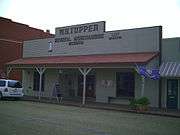
 The front facade of the W. H. Tupper General Merchandise Museum, circa 2008 | |
| Motto: "Cradle of Louisiana Oil"[1] | |
| Country | United States |
|---|---|
| State | Louisiana |
| Parish | Jefferson Davis |
| Elevation | 26 ft (7.9 m) |
| Coordinates | 30°13′20″N 92°39′25″W / 30.22222°N 92.65694°WCoordinates: 30°13′20″N 92°39′25″W / 30.22222°N 92.65694°W |
| Area | 10.3 sq mi (26.7 km2) |
| - land | 10.2 sq mi (26 km2) |
| - water | 0.04 sq mi (0 km2), 0.39% |
| Population | 10,383 (2000) |
| Founded | May 2, 1888 |
| Timezone | CST (UTC-6) |
| - summer (DST) | CDT (UTC-5) |
| ZIP code | 70546 |
| Area code | 337 |
|
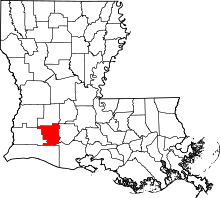
Location of Jennings in Louisiana | |
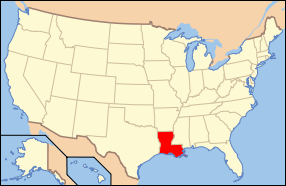
 Location of Louisiana in the United States | |
| Website: City of Jennings, Louisiana | |
Jennings is a small city in and the parish seat of Jefferson Davis Parish, Louisiana, United States,[2] near Lake Charles. The population was 10,383 at the 2010 census, a small decline from the 2000 tabulation. The city is 68 percent white.[3]
Jennings is the principal city of the Jennings Micropolitan Statistical Area, which includes all of Jefferson Davis Parish. It is also part of the larger Lake Charles-Jennings Combined Statistical Area.
History
Jennings McComb, for whom the town was named, was a contractor of the Southern Pacific Railroad. He built the Jennings depot on a divide peculiar to southwest Louisiana.
The first settler was A. D. McFarlain, who came from St. Mary Parish, in 1881. McFarlain was the community’s first rice grower, merchant, postmaster, brick maker, and builder. McFarlain prospered with Jennings’ growth and later became one of the town’s most prominent businessmen and civic leaders. He opened a store in Jennings in 1881.
The Jennings area was settled by Anglo wheat farmers of Iowa, Kansas, Nebraska and other Midwestern states. The new settlers of southwest Louisiana were referred to as "Yankees" by the natives. The Cajuns gave appreciable aid to the settlers in homesteading and homemaking. The people grew rice, cotton, sweet potatoes and corn.[4]
Sylvester L. Cary, who arrived on February 7, 1883 from Iowa and known as the town's "father", stated he was "seeking a home where there was neither winter or mortgages." So impressed was "Father" Cary by the attractiveness of the country around Jennings that he felt impelled to share his findings with others. The conviction resulted in his entering upon the second phase of his great adventure, that of bringing fellow Midwesterners to southwest Louisiana. He began to write letters to his friends in Iowa, extolling the advantages of the countryside surrounding Jennings. When he returned to Iowa to remove his family to their newly acquired home, he successfully persuaded several neighbors, preparing to migrate west, to take advantage of the opportunities he had discovered in Jennings and southwest Louisiana.[4]
Much of southwest Louisiana was developed by the North American Land and Timber Co. Seaman A. Knapp, president of the Iowa State College of Agriculture, was engaged in 1885 to demonstrate the suitability of the region for rice production. Knapp attracted a number of Iowans to settle the area.[5] The settlers were lured to this area by advertisements published in newspapers in the midwestern states.
On May 2, 1888 the settlement of Jennings was incorporated into a village. In 1901, a fire destroyed a large portion of Jennings. However, that same year, Jennings was the location of the first oil well and oil field in the state of Louisiana. Oil brought a boom to the town but this was only a peak in its continuous growth. When oil production declined, the basic agricultural economy kept the town prosperous.[4]
Geography
Jennings is located at 30°13′20″N 92°39′25″W / 30.22222°N 92.65694°W (30.222207, -92.656880)[6] and has an elevation of 26 feet (7.9 m).[7]
According to the United States Census Bureau, the city has a total area of 10.3 square miles (27 km2), of which 10.2 square miles (26 km2) is land and 0.04 square miles (0.10 km2) (0.19%) is water.
Demographics
| Historical population | |||
|---|---|---|---|
| Census | Pop. | %± | |
| 1890 | 412 | — | |
| 1900 | 1,539 | 273.5% | |
| 1910 | 3,925 | 155.0% | |
| 1920 | 3,824 | −2.6% | |
| 1930 | 4,036 | 5.5% | |
| 1940 | 7,343 | 81.9% | |
| 1950 | 9,663 | 31.6% | |
| 1960 | 11,887 | 23.0% | |
| 1970 | 11,783 | −0.9% | |
| 1980 | 12,401 | 5.2% | |
| 1990 | 11,305 | −8.8% | |
| 2000 | 10,986 | −2.8% | |
| 2010 | 10,383 | −5.5% | |
| Est. 2015 | 10,180 | [8] | −2.0% |
As of the census of 2000, there were 10,986 people, 4,090 households, and 2,875 families residing in the city. The population density was 1,072.6 people per square mile (414.2/km²). There were 4,541 housing units at an average density of 443.4 per square mile (171.2/km²). The racial makeup of the city was 70.42% White, 28.00% African American, 0.37% Native American, 0.29% Asian, 0.22% from other races, and 0.70% from two or more races. Hispanic or Latino of any race were 0.92% of the population.
There were 4,090 households out of which 34.8% had children under the age of 18 living with them, 48.1% were married couples living together, 18.4% had a female householder with no husband present, and 29.7% were non-families. 26.3% of all households were made up of individuals and 12.9% had someone living alone who was 65 years of age or older. The average household size was 2.61 and the average family size was 3.16.
In the city the population was spread out with 28.8% under the age of 18, 9.6% from 18 to 24, 25.7% from 25 to 44, 20.2% from 45 to 64, and 15.7% who were 65 years of age or older. The median age was 35 years. For every 100 females there were 87.0 males. For every 100 females age 18 and over, there were 81.3 males.
The median income for a household in the city was $24,410, and the median income for a family was $30,783. Males had a median income of $26,630 versus $19,010 for females. The per capita income for the city was $12,357. About 22.4% of families and 26.2% of the population were below the poverty line, including 34.3% of those under the age of 18 and 18.1% of those ages 65 or older.
Notable people
- A.C. Clemons (1921–1992), first Republican in the 20th century to serve in the Louisiana State Senate
- Chancy Croft (born 1937) Born in Jennings. Moved to Odessa, Texas, then Anchorage, Alaska. President of the Alaska Senate (1975–1977), Democratic Party nominee for Alaska governor (1978), President of the University of Alaska Board of Regents (2001–2002).
- Cleve Francis (born 1945) Country music artist, released three albums in the early 1990's.
- John E. Guinn, current member of the Louisiana House of Representatives from Jennings
- Eugene John Hebert (1923–1990), Society of Jesus Roman Catholic priest who disappeared in Sri Lanka
- W. Scott Heywood (1872–1950), member of the Louisiana State Senate from 1932–1936, author of homestead exemption; discovered oil in Jeff Davis Parish in 1901
- Charles Franklin Hildebrand (1893-1966), publisher of the Jeff Davis Parish News (1930-1948) and the Jennings Daily News (1948-1957)
- June James, NFL player
- Claude Kirkpatrick (1917–1997), member of the Louisiana House of Representatives (1952-1960] from Jefferson Davis Parish, director of Louisiana Department of Public Works (1960–1964), candidate for governor in 1963, instigator of Toledo Bend Reservoir, president of Baton Rouge General Hospital, and builder of three shopping centers in Baton Rouge
- Edith Killgore Kirkpatrick (born 1918), member of Louisiana Board of Regents, 1978–1990; music educator; Baptist state official
- Monte Ledbetter, American football player
- Dan Morrish, Jennings businessman, former state representative, current state senator
- Pat Rapp, Former MLB player (San Francisco Giants, Florida Marlins, Kansas City Royals, Boston Red Sox, Baltimore Orioles, Anaheim Angels)[10]
- Guy Sockrider, member of the Louisiana State Senate from Jennings from 1948 to 1964; industrialist in Jennings and later Lake Charles[11]
- Gerald Theunissen, Jennings banker and former member of both houses of the state legislature
- Donald Ellsworth Walter, U.S. District Judge for the United States District Court for the Western District of Louisiana, based in Shreveport; U.S. attorney from 1969 to 1977, born in Jennings in 1936
Education
Jefferson Davis Parish Public Schools operates public schools serving Jennings. The schools serving Jennings, all within the city, include Ward Elementary School (PK-2), Jennings Elementary School (3-6), and Jennings High School (7-12) .
Bethel Christian School is a PreK-12 Christian school located in unincorporated Jefferson Davis Parish, near Jennings.[12]
Jefferson Davis Parish Library operates the Headquarters Branch at 118 West Plaquemine Street in Jennings. In addition the City of Jennings operates the Jennings Carnegie Public Library at 303 North Cary Avenue.[13]
Climate
The climate in this area is characterized by hot, humid summers and generally mild to cool winters. According to the Köppen Climate Classification system, Jennings has a humid subtropical climate, abbreviated "Cfa" on climate maps.[14]
References
- ↑ "City of Jennings, Louisiana". City of Jennings, Louisiana. Retrieved August 26, 2012.
- ↑ "Find a County". National Association of Counties. Retrieved 2011-06-07.
- ↑ "Jennings (city), Louisiana". quickfacts.census.gov. Retrieved November 26, 2012.
- 1 2 3 library.mcneese.edu "THE HISTORY OF JENNINGS, LOUISIANA"
- ↑ Letter of Nancy B. Vezinet, archivist for the State of Louisiana, Mar. 24, 1982. She excerpted the relevant passages from Cities and Towns if Louisiana by Clare D'Artois Leeper. Cf. also "The Vinton-Lake Charles Colony" by A. A. Wentz in the Vinton (Ia.) Eagle, Apr. 14, 1896.
- ↑ "US Gazetteer files: 2010, 2000, and 1990". United States Census Bureau. 2011-02-12. Retrieved 2011-04-23.
- ↑ "US Board on Geographic Names". United States Geological Survey. 2007-10-25. Retrieved 2008-01-31.
- ↑ "Annual Estimates of the Resident Population for Incorporated Places: April 1, 2010 to July 1, 2015". Retrieved July 2, 2016.
- ↑ "Census of Population and Housing". Census.gov. Retrieved June 4, 2015.
- ↑ "Pat Rapp Stats". Baseball Almanac. Retrieved November 26, 2012.
- ↑ "Guy Sockrider". obits.dignitymemorial.com. February 27, 2011. Retrieved November 1, 2014.
- ↑ "Contact Information." Bethel Christian School. Retrieved on November 26, 2012. "15147 Hwy 102 Jennings, LA 70546"
- ↑ "Carnegie Public Library:." City of Jennings. Accessed September 22, 2008.
- ↑ Climate Summary for Jennings, Louisiana
