Jiangsu
| Jiangsu Province 江苏省 | |
|---|---|
| Province | |
| Name transcription(s) | |
| • Chinese | 江苏省 (Jiāngsū Shěng) |
| • Abbreviation | 苏 (pinyin: Sū) |
| • Wu | Kaonsu San |
.svg.png) Map showing the location of Jiangsu Province | |
| Coordinates: 32°54′N 119°48′E / 32.9°N 119.8°ECoordinates: 32°54′N 119°48′E / 32.9°N 119.8°E | |
| Named for |
江 Jiangning (now Nanjing) 苏 Suzhou |
| Capital (and largest city) | Nanjing |
| Divisions | 13 prefectures, 106 counties, 1488 townships |
| Government | |
| • Secretary | Li Qiang |
| • Governor | Shi Taifeng |
| Area | |
| • Total | 102,600 km2 (39,600 sq mi) |
| Area rank | 25th |
| Population (2012)[1] | |
| • Total | 79,200,000 |
| • Rank | 5th |
| • Density | 770/km2 (2,000/sq mi) |
| • Density rank | 4th |
| Demographics | |
| • Ethnic composition |
Han – 99.6% Hui – 0.2% |
| • Languages and dialects | Jianghuai Mandarin, Wu, Zhongyuan Mandarin |
| ISO 3166 code | CN-32 |
| GDP (2015) |
CNY 7.2 trillion $ 1.1 trillion[2] (2nd) |
| • per capita |
CNY 90,800 US$ 14,100 (4th) |
| HDI (2010) | 0.748[3] (high) (4th) |
| Website |
www |
| Jiangsu | |||||||||||||||||||||||||||||
|
"Jiangsu" in Simplified (top) and Traditional (bottom) Chinese characters | |||||||||||||||||||||||||||||
| Simplified Chinese | 江苏 | ||||||||||||||||||||||||||||
|---|---|---|---|---|---|---|---|---|---|---|---|---|---|---|---|---|---|---|---|---|---|---|---|---|---|---|---|---|---|
| Traditional Chinese | 江蘇 | ||||||||||||||||||||||||||||
| Postal | Kiangsu | ||||||||||||||||||||||||||||
| Literal meaning | Nanjing (from its former name Jiangning) and Suzhou | ||||||||||||||||||||||||||||
| |||||||||||||||||||||||||||||
.svg.png)
Jiangsu (![]() listen ), formerly romanized as Kiangsu, is an eastern-central coastal province of the People's Republic of China, one of the leading provinces in manufacturing electronics and apparel items, with its capital in Nanjing. Jiangsu is the second smallest, but the fifth most populous and the most densely populated of the 23 provinces of the People's Republic of China. Jiangsu has the second highest GDP of Chinese provinces, after Guangdong.[4] Jiangsu borders Shandong in the north, Anhui to the west, and Zhejiang and Shanghai to the south. Jiangsu has a coastline of over 1,000 kilometres (620 mi) along the Yellow Sea, and the Yangtze River passes through the southern part of the province.
listen ), formerly romanized as Kiangsu, is an eastern-central coastal province of the People's Republic of China, one of the leading provinces in manufacturing electronics and apparel items, with its capital in Nanjing. Jiangsu is the second smallest, but the fifth most populous and the most densely populated of the 23 provinces of the People's Republic of China. Jiangsu has the second highest GDP of Chinese provinces, after Guangdong.[4] Jiangsu borders Shandong in the north, Anhui to the west, and Zhejiang and Shanghai to the south. Jiangsu has a coastline of over 1,000 kilometres (620 mi) along the Yellow Sea, and the Yangtze River passes through the southern part of the province.
Since the Sui and Tang dynasties, Jiangsu has been a national economic and commercial center, partly due to the construction of Grand Canal. Cities such as Yangzhou, Nanjing, Wuxi, Suzhou and Shanghai (separated from Jiangsu in 1927) are all major Chinese economic hubs. Since the initiation of economic reforms in 1990, Jiangsu has become a focal point for economic development. It is widely regarded as China's most developed province measured by its Human Development Index (HDI).[3] However, its development is not evenly distributed, with the Wu-speaking southern part of the province being significantly more well-off than its Mandarin-speaking north, which sometimes causes tensions between northern and southern residents.[5]
Jiangsu is home to many of the world's leading exporters of electronic equipment, chemicals and textiles.[6] It has also been China's largest recipient of foreign direct investment since 2006. Its 2014 nominal GDP was more than 1 trillion US dollars, which is the sixth highest of all country subdivisions.
Name
Its name is a compound of the first elements of the names of the two cities of Jiangning (now Nanjing) and Suzhou. The abbreviation for this province is "苏" (Sū), the second character of its name.[7]
History
During the earliest Chinese dynasties, the area in what is now Jiangsu was far removed from the center of Chinese civilization, which was in the northwest Henan; it was home of the Huai Yi (淮夷), an ancient ethnic group. During the Zhou Dynasty more contact was made, and eventually the state of Wu (centered at Gusu, now Suzhou) appeared as a vassal to the Zhou Dynasty in south Jiangsu, one of the many hundreds of states that existed across northern and central China at that time. Near the end of the Spring and Autumn period, Wu became a great power under King Helu of Wu, and was able to defeat in 484 BC the state of Qi, a major power in the north in modern-day Shandong province, and contest for the position of overlord over all states of China. The state of Wu was subjugated in 473 BC by the state of Yue, another state that had emerged to the south in modern-day Zhejiang province. Yue was in turn subjugated by the powerful state of Chu from the west in 333 BC. Eventually the state of Qin swept away all the other states, and established China as a unified nation in 221 BC.[8]
Under the reign of the Han Dynasty (206 BC to 220 AD), Jiangsu was removed from the centers of civilization in the North China Plain, and was administered under two zhou (provinces): Xuzhou Province in the north, and Yangzhou Province in the south. During the Three Kingdoms period, southern Jiangsu became the base of the Eastern Wu (222 to 280) whose capital, Jiankang, is modern Nanjing. When nomadic invasions overran northern China in the 4th century, the imperial court of the Jin Dynasty moved to Jiankang. Cities in southern and central Jiangsu swelled with the influx of migrants from the north. Jiankang remained as the capital for four successive Southern Dynasties and became the largest commercial and cultural center in China.[9]
After the Sui Dynasty united the country in 581, the political center of the country shifted back to the north, but the Grand Canal was built through Jiangsu to link the Central Plain with the prosperous Yangtze Delta. The Tang Dynasty (618 to 907) relied on southern Jiangsu for annual deliveries of grain. It was during the Song Dynasty (960-1279), which saw the development of a wealthy mercantile class and emergent market economy in China, that south Jiangsu emerged as a center of trade. From then onwards, south Jiangsu, especially major cities like Suzhou or Yangzhou, would be synonymous with opulence and luxury in China. Today south Jiangsu remains one of the richest parts of China, and Shanghai, arguably the wealthiest and most cosmopolitan of mainland China cities, is a direct extension of south Jiangsu culture.
The Jurchen Jin Dynasty gained control of North China in 1127 during the Jin-Song wars, and Huai River, which used to cut through north Jiangsu to reach the Yellow Sea, was the border between the north, under the Jin, and the south, under the Southern Song Dynasty. The Mongols took control of China in the thirteenth century. The Ming Dynasty, which was established in 1368 after driving out the Mongols who had occupied China, initially put its capital in Nanjing. Following a coup by Zhu Di (later, the Yongle Emperor), however, the capital was moved to Beijing, far to the north. (The naming of the two cities continue to reflect this: "Nanjing" literally means "southern capital", "Beijing" literally means "northern capital.) The entirety of modern day Jiangsu as well as neighbouring Anhui province kept their special status, however, as territory-governed directly by the central government, and were called Nanzhili (南直隸 "Southern directly governed"). Meanwhile, South Jiangsu continued to be an important center of trade in China; some historians see in the flourishing textiles industry at the time incipient industrialization and capitalism, a trend that was however aborted, several centuries before similar trends took hold in the West.
The Qing Dynasty changed this situation by establishing Nanzhili as Jiangnan province; in 1666 Jiangsu and Anhui were split apart as separate provinces, and Jiangsu was given borders approximately the same as today.
"In 1727 the to-min or "idle people" of Cheh Kiang province (a Ningpo name still existing), the yoh-hu or "music people" of Shan Si province, the si-min or "small people" of Kiang Su province, and the tan-ka or "egg-people" of Canton (to this day the boat population there), were all freed from their social disabilities, and allowed to count as free men."[10]
With the start of the Western incursion into China in the 1840s, the rich and mercantile south Jiangsu was increasingly exposed to Western influence; Shanghai, originally an unremarkable little town of Jiangsu, quickly developed into a metropolis of trade, banking, and cosmopolitanism, and was split out later as an independent municipality. South Jiangsu also figures strongly in the Taiping Rebellion (1851 – 1864), a massive and deadly rebellion that attempted to set up a Christian theocracy in China; it started far to the south in Guangdong province, swept through much of South China, and by 1853 had established Nanjing as its capital, renamed as Tianjing (天京 "Heavenly Capital").
The Republic of China was established in 1912,[11] and China was soon torn apart by warlords. Jiangsu changed hands several times, but in April 1927 Chiang Kai-shek established a government at Nanjing; he was soon able to bring most of China under his control. This was however interrupted by the second Sino-Japanese War, which began full-scale in 1937; on December 13, 1937, Nanjing fell, and the combined atrocities of the occupying Japanese for the next 3 months would come to be known as the Nanjing Massacre. Nanjing was the seat of the collaborationist government of East China under Wang Jingwei, and Jiangsu remained under occupation until the end of the war in 1945.
After the war, Nanjing was once again the capital of the Republic of China, though now the Chinese Civil War had broken out between the Kuomintang government and Communist forces, based further north, mostly in Northeast China. The decisive Huaihai Campaign was fought in northern Jiangsu; it resulted in Kuomintang defeat, and the communists were soon able to cross the Yangtze River and take Nanjing. The Kuomintang fled southwards, and eventually ended up in Taipei, from which the Republic of China government continues to administer Taiwan and its neighboring islands, though it also continues to claim (technically, at least) Nanjing as its rightful capital.
After communist takeover, Beijing was made capital of the People's Republic and Nanjing was demoted to be the provincial capital of Jiangsu. The economic reforms of Deng Xiaoping initially focused on the south coast of China, in Guangdong province, which soon left Jiangsu behind; starting from the 1990s they were applied more evenly to the rest of China. Suzhou and Wuxi, two southern cities of Jiangsu in close proximity to neighboring Shanghai, have since become particularly prosperous, being among the top 10 cities in China in gross domestic product and outstripping the provincial capital of Nanjing. The income disparity between north Jiangsu and south Jiangsu however remains large.
Geography

Jiangsu is very flat and low-lying, with plains covering 68 percent of its total area (water covers another 18 percent), and most of the province stands not more than 50 metres (160 ft) above sea level. Jiangsu is also laced with a well-developed irrigation system, which earned it (especially the southern half) the moniker of 水乡 (shuǐxiāng "land of water"); the southern city of Suzhou is so crisscrossed with canals that it has been dubbed "Venice of the East" or the "Venice of the Orient".[12][13] The Grand Canal of China cuts through Jiangsu from north to south, traversing all the east-west river systems. Jiangsu also borders the Yellow Sea. The Yangtze River, the longest river of China, cuts through the province in the south and reaches the East China Sea. Mount Yuntai near the city of Lianyungang is the highest point in this province, with an altitude of 625 metres (2,051 ft) above sea level. Large lakes in Jiangsu include Lake Taihu (the largest), Lake Hongze, Lake Gaoyou, Lake Luoma, and Lake Yangcheng.
Historically Huai River, a major river in central China and the traditional border between North China and South China, cut through north Jiangsu to reach the Yellow Sea. However, from 1194 the Yellow River further to the north changed its course several times, running into the Huai River in north Jiangsu each time instead of its other usual path northwards into Bohai Bay. The silting caused by the Yellow River was so heavy that after its last episode of "hijacking" the Huai River ended in 1855: the Huai River was no longer able to go through its usual path into the sea. Instead it flooded, pooled up (thereby forming and enlarging Lake Hongze and Lake Gaoyou), and flowed southwards through the Grand Canal into the Yangtze. The old path of the Huai River is now marked by a series of irrigation channels, the most significant of which is the North Jiangsu Main Irrigation Canal (苏北灌溉总渠), which channels a small amount of the water of the Huai River alongside south of its old path into the sea.

Most of Jiangsu has a humid subtropical climate (Cfa or Cwa in the Köppen climate classification), beginning to transition into a humid continental climate (Köppen Dwa) in the far north. Seasonal changes are clear-cut, with temperatures at an average of −1 to 4 °C (30 to 39 °F) in January and 26 to 29 °C (79 to 84 °F) in July. Rain falls frequently between spring and summer (meiyu), typhoons with rainstorms occur in late summer and early autumn. As with the rest of the coast, tornados are possible. The annual average rainfall is 800 to 1,200 millimetres (31 to 47 in), concentrated mostly in summer during the southeast monsoon.
Major cities:[14]
Administrative divisions
Jiangsu is divided into thirteen prefecture-level divisions, all prefecture-level cities (including a sub-provincial city):
| Administrative divisions of Jiangsu | ||||||||||
|---|---|---|---|---|---|---|---|---|---|---|
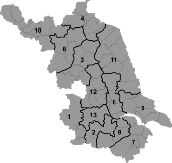 | ||||||||||
| № | Division code[15] | English name | Chinese | Pinyin | Area in km2[16] | Population 2010[17] | Seat | Divisions | ||
| Districts | Counties | CL cities | ||||||||
| 320000 | Jiangsu | 江苏省 | Jiāngsū Shěng | 102600.00 | 78,659,903 | Nanjing | 55 | 21 | 21 | |
| 1 | 320100 | Nanjing | 南京市 | Nánjīng Shì | 6582.31 | 8,004,680 | Xuanwu District | 11 | ||
| 9 | 320200 | Wuxi | 无锡市 | Wúxī Shì | 4787.61 | 6,372,624 | Binhu District | 5 | 2 | |
| 10 | 320300 | Xuzhou | 徐州市 | Xúzhōu Shì | 11764.88 | 8,580,500 | Yunlong District | 5 | 3 | 2 |
| 2 | 320400 | Changzhou | 常州市 | Chángzhōu Shì | 4384.57 | 4,591,972 | Xinbei District | 5 | 1 | |
| 7 | 320500 | Suzhou | 苏州市 | Sūzhōu Shì | 8488.42 | 10,465,994 | Gusu District | 5 | 4 | |
| 5 | 320600 | Nantong | 南通市 | Nántōng Shì | 8001.00 | 7,282,835 | Chongchuan District | 3 | 2 | 3 |
| 4 | 320700 | Lianyungang | 连云港市 | Liányúngǎng Shì | 7615.29 | 4,393,914 | Haizhou District | 3 | 3 | |
| 3 | 320800 | Huai'an | 淮安市 | Huái'ān Shì | 9949.97 | 4,799,889 | Qingjiangpu District | 4 | 4 | |
| 11 | 320900 | Yancheng | 盐城市 | Yánchéng Shì | 16972.42 | 7,260,240 | Tinghu District | 3 | 5 | 1 |
| 12 | 321000 | Yangzhou | 扬州市 | Yángzhōu Shì | 6591.21 | 4,459,760 | Hanjiang District | 3 | 1 | 2 |
| 13 | 321100 | Zhenjiang | 镇江市 | Zhènjiāng Shì | 3840.32 | 3,113,384 | Jingkou District | 3 | 3 | |
| 8 | 321200 | Taizhou | 泰州市 | Tàizhōu Shì | 5787.26 | 4,618,558 | Hailing District | 3 | 3 | |
| 6 | 321300 | Suqian | 宿迁市 | Sùqiān Shì | 8555.00 | 4,715,553 | Sucheng District | 2 | 3 | |
The thirteen prefecture-level divisions of Jiangsu are subdivided into 98 county-level divisions (56 districts, 21 county-level cities, and 21 counties). Those are in turn divided into 1,488 township-level divisions (1,078 towns, 122 townships, one ethnic township, and 287 subdistricts).
Politics
The politics of Jiangsu is structured in a one party (Communist) government system like all other governing institutions in mainland China.
The Governor of Jiangsu is the highest-ranking official in the People's Government of Jiangsu. However, in the province's dual party-government governing system, the Governor has less power than the Jiangsu Communist Party of China Provincial Committee Secretary, colloquially termed the "Jiangsu CPC Party Chief".
Economy
Jiangsu has the highest GDP per capita of all Chinese provinces.
The province has an extensive irrigation system supporting its agriculture, which is based primarily on rice and wheat, followed by maize and sorghum. Main cash crops include cotton, soybeans, peanuts, rapeseed, sesame, ambary hemp, and tea. Other products include peppermint, spearmint, bamboo, medicinal herbs, apples, pears, peaches, loquats, ginkgo. Silkworms form an important part of Jiangsu's agriculture, with the Lake Taihu region to the south a major base of silk production in China. Jiangsu is an important producer of freshwater fish and other aquatic products.
Jiangsu has coal, petroleum, and natural gas deposits, but its most significant mineral products are non-metal minerals such as halite (rock salt), sulfur, phosphorus, and marble. The city of Xuzhou is a coal hub of China. The salt mines of Huaiyin have more than 0.4 trillion tonnes of deposits, one of the greatest collections of deposits in China.
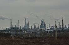
Jiangsu is historically oriented toward light industries such as textiles and food industry. Since 1949, Jiangsu has developed heavy industries such as chemical industry and construction materials. Jiangsu's important industries include machinery, electronic, chemicals, and automobile.[18][19] The government has worked hard to promote the solar industry and hoped by 2012 the solar industry would be worth 100 billion RMB.[20] The economic reforms of Deng Xiaoping have greatly benefited southern cities, especially Suzhou and Wuxi, which outstrip the provincial capital Nanjing in total output. In the eastern outskirts of Suzhou, Singapore has built the Suzhou Industrial Park, a flagship of Sino-Singaporean cooperation and the only industrial park in China that is in its entirety the investment of a single foreign country.
Jiangsu is very wealthy among the provinces of China, with the second highest total GDP, after Guangdong Province. Its GDP per capita was 44,232 yuan in 2009, but a wealth gap between the prosperous south and poorer north has led to unequal economic growth.[18] Cities like Nanjing, Suzhou and Wuxi have GDP per capita around twice the provincial average, making south Jiangsu one of the most prosperous regions in China.
In 2011, Jiangsu's nominal GDP was 4.80 trillion yuan (US$759 billion), making it the second largest GDP of all the provinces and an annual growth rate of 12.4%. Its per capita GDP was 52,448 yuan (US$7,945). In 2009, the share of GDP of Jiangsu's primary, secondary, and tertiary industries were 6.4%, 54.1%, and 39.5% respectively.
Jiangsu contains over 100 different economic and technological development zones devoted to different types of investments.[21]
Demographics
| Historical population | ||
|---|---|---|
| Year | Pop. | ±% |
| 1912[22] | 32,283,000 | — |
| 1928[23] | 34,126,000 | +5.7% |
| 1936–37[24] | 36,469,000 | +6.9% |
| 1947[25] | 36,080,000 | −1.1% |
| 1954[26] | 41,252,192 | +14.3% |
| 1964[27] | 44,504,608 | +7.9% |
| 1982[28] | 60,521,114 | +36.0% |
| 1990[29] | 67,056,519 | +10.8% |
| 2000[30] | 73,043,577 | +8.9% |
| 2010[31] | 78,659,903 | +7.7% |
| Shanghai was part of Jiangsu Province until 1927. Nanjing part of Jiangsu Province until 1927; dissolved in 1952 and incorporated into Jiangsu Province. | ||
The majority of Jiangsu residents are ethnic Han Chinese. Other minorities include the Hui and the Manchus.
- Demographic indicators in 2000
Population: 74.058 million (urban: 34.637 million; rural: 39.421 million) (2003)
Birth rate: 9.04 per 1000 (2003)
Death rate: 7.03 per 1000 (2003)
Sex ratio: 102.55 males per 100 females
Average family size: 3.25
Han Chinese proportion: 99.64%
Literacy rate: 97.88%
Religion

The predominant religions in Jiangsu are Chinese folk religions, Taoist traditions and Chinese Buddhism. According to surveys conducted in 2007 and 2009, 16.67% of the population believes and is involved in cults of ancestors, while 2.64% of the population identifies as Christian.[32] The reports didn't give figures for other types of religion; 80.69% of the population may be either irreligious or involved in worship of nature deities, Buddhism, Confucianism, Taoism, folk religious sects, and small minorities of Muslims.

Transportation
Jiangsu is home to one of the most extensive transportation networks in China.
Air
Nanjing Lukou International Airport (IATA: NKG) serves as the major airport in the province, with flights to Tokyo, Osaka, Hong Kong, Seoul-Incheon, Frankfurt and Bangkok. Other passenger airports include Changzhou Benniu Airport, Sunan Shuofang International Airport, Yangzhou Taizhou Airport, and Nantong Airport. Air traffic in the populated Suzhou area is often diverted to Shanghai Hongqiao Airport, to which Suzhou is conveniently connected to via bus services and by expressway.
Xuzhou Guanyin Airport, Yancheng Nanyang Airport, and Lianyungang Baitabu Airport serve as hubs in northern Jiangsu.
Rail
The southern part of the province, namely the Shanghai-Nanjing corridor, has very high-frequency rail services. Jiangsu is en route of the Jinghu Railway from Beijing to Shanghai, as well as the high speed line between the two cities completed in 2011. Since the completion of the Beijing-Shanghai high speed line, travel time between Beijing and Nanjing has been reduced to approximately four hours (from eleven hours previously); travel time between Nanjing and Shanghai is 1 hour and 39 minutes.
Between the major urban centres of Suzhou and Nanjing, it is possible to catch a high-speed train every five to ten minutes during the day. The conventional and high-speed trains pass through Kunshan, Suzhou, Wuxi, Changzhou, Danyang, Zhenjiang, and Nanjing. Yangzhou has been connected by railway since 2004, and Yancheng since 2007. As of 2007, all major cities in Jiangsu except Suqian have been connected, though discussions are under way to connect Suqian with Xuzhou and Yancheng via intercity rail as of late 2014. The Xinchang Railway originates in Xinyi and heads south, passing through Huai'an, Yancheng, Taizhou, Hai'an, Jiangyin and Yixing.
Xuzhou, a city in northeast Jiangsu, is a very important railway junction in the province as well as the whole of China. Its prominence as a railway hub dates back to at least the Mao era. In 1975, then Vice-Premier Deng Xiaoping targeted railway operations in Xuzhou as part of his overall economic reform efforts in the waning days of the Cultural Revolution. Xuzhou is the crossing point of Longhai Railway and Jinghu railway, and its railway station is among the largest in China. The Longhai railway terminates at port city of Lianyungang near the shore of the Pacific Ocean.
Road
Jiangsu's road network is one of the most developed in the country.[33] The Beijing–Shanghai Expressway (G2) enters the province from the north and passes through Huai'an, Yangzhou, Taizhou, and Wuxi on the way to Shanghai; travelling from Shanghai westbound, G2 forks at Wuxi and continues onto Nanjing separately as G42, the Shanghai–Nanjing Expressway, which serves the widely travelled southern corridor of the province. The Ningchang Expressway links Nanjing with Changzhou. The Suzhou area is extensively networked with expressways, going in all directions. The Yanhai Expressway links the coastal regions of the province, passing through Nantong, Yancheng, and Lianyungang.
Historically, the province was divided by the Yangtze River into northern and southern regions. The first bridge across the river in Jiangsu, the Nanjing Yangtze River Bridge, was completed in 1968 during the Cultural Revolution. The second bridge crossing, Jiangyin Bridge, opened 30 years later at Jiangyin. As of October 2014, there were 11 cross-Yangtze bridges in the province, including the five in Nanjing, which also has two cross-river tunnels. The Jiangyin Bridge (1,385 m (4,544 ft)), Runyang Bridge (opened in 2005, connecting Yangzhou and Zhenjiang, 1,490 m (4,890 ft)), and Fourth Nanjing Bridge (opened in 2012; 1,418 m (4,652 ft)) all rank among the ten longest suspension bridges in the world. The Sutong Bridge, opened in 2008, connecting Nantong and Changshu, has one of the longest cable-stayed bridge spans in the world, at 1,088 m (3,570 ft).
Culture
The province of Jiangsu originated in the seventeenth century with the splitting of the defunct and erroneously named Jiangnan Province ("south of the river") into Jiangsu and Anhui. Before then, the northern and southern parts of Jiangsu had less connection with each other than they later did. Traditionally, South Jiangsu is referred to as the three more prosperous southern cities including Suzhou, Wuxi and Changzhou. Their culture (the "Jiangnan" culture shared with Shanghai and Zhejiang) is more southern than the rest and is oftened referred to as the Wu. Northern Jiangsu, more specifically the cities of Xuzhou and Lianyungang are part of the North China Plain and Southern Shandong by culture. by Central and north-central parts of the province are dominated by the so-called "Jianghuai Culture", which means the culture in the area between the Yangtse River (Jiang) and Huaihe River (Huai), though not all of them lie within the district defined by the term. In history, the term North Jiangsu refers to the cities to the north of the Yangtze River. For cities of Nanjing and Zhenjiang, neither the two terms (North Jiangsu and South Jiangsu) refers to them, because though they are to the south of the River, culturally they are still of the Jianghuai Region. Since about 1998, there is a new classification used frequently by the government and defined by economic means. It groups all the cities to the south of the Yangtse River as South Jiangsu, the cities of Yangzhou, Nantong and Taizhou as Middle Jiangsu, and all the rest as North Jiangsu.
Though the terms of classification are very complex, by cultural means only the very north cities of Xuzhou, Suqian and Lianyungang are culturally north Chinese. All the rest areas of the province are culturally south, though the three South Jiangsu cities are more purely southern while the culture in other cities is more a transitional mixture dominated by the southern.

Two main subdivisions of the Chinese language, Mandarin (not Putonghua, the national standard speech based on the Beijing dialect, also commonly called Mandarin) and Wu, are spoken in different parts of Jiangsu. Mandarin dialects are spoken over the traditional North Jiangsu, while the Wu language is used in South Jiangsu. Mandarin and Wu are not mutually intelligible and the dividing line is sharp and well-defined. (See also Nanjing dialect, Xuzhou dialect, Yangzhou dialect, Suzhou dialect, Wuxi dialect, Changzhou dialect). In addition, Standard Chinese (Putonghua/Mandarin) is also spoken by most people.
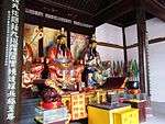
Jiangsu is rich in cultural traditions. Kunqu, originating in Kunshan, is one of the most renowned and prestigious forms of Chinese opera. Pingtan, a form of storytelling accompanied by music, is also popular: it can be subdivided into types by origin: Suzhou Pingtan (of Suzhou), Yangzhou Pingtan (of Yangzhou), and Nanjing Pingtan (of Nanjing). Xiju, a form of traditional Chinese opera, is popular in Wuxi, while Huaiju is popular further north, around Yancheng. Jiangsu cuisine is one of the eight great traditions of the cuisine of China.
Suzhou is also well known for its silk, Chinese embroidery, jasmine tea, stone bridges, pagodas, and its classical gardens. Nearby Yixing is noted for its teaware while Yangzhou is known for its lacquerware and jadeware. Nanjing's yunjin is a noted type of woven silk, while Wuxi is well known for its peaches.
Since ancient times, south Jiangsu has been famed for its prosperity and opulence, and simply inserting south Jiangsu place names (Suzhou, Yangzhou, etc.) into poetry gave an effect of dreaminess, as was indeed done by many famous poets. In particular, the fame of Suzhou (as well as Hangzhou in neighbouring Zhejiang) has led to the popular saying: 上有天堂,下有蘇杭 ("above there is heaven; below there are Suzhou and Hangzhou"), a saying that continues to be a source of pride for the people of these two still prosperous cities. Similarly, the prosperity of Yangzhou has led poets to dream of: 腰纏十萬貫,騎鶴下揚州 ("with a hundred thousand strings of coins wrapped around its waist, a crane landed in Yangzhou").
Higher education
As of 2015, Jiangsu hosts 137 institutions of higher education, ranking 1st of all Chinese provinces. There are 2 Project 985 and 11 Project 211 universities in the province. A combination of 93 members of Chinese Academy of Sciences and Chinese Academy of Engineering work in Jiangsu.[34]
- China Pharmaceutical University, a Project 211 university.
- China University of Mining and Technology, a Project 211 university.
- Hohai University, a Project 211 university.
- Nanjing University, a Project 985 & Project 211 university.
- Nanjing Agricultural University, a Project 211 university.
- Nanjing Normal University, a Project 211 university.
- Nanjing University of Aeronautics and Astronautics, a Project 211 university.
- Nanjing University of Science and Technology, a Project 211 university.
- Jiangnan University, a Project 211 university.
- Southeast University, a Project 985 & Project 211 university.
- Suzhou University, a Project 211 university.
Tourism
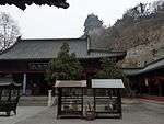
Nanjing was the capital of several Chinese dynasties and contains a variety of historic sites, such as the Purple Mountain, Purple Mountain Observatory, the Sun Yat-sen Mausoleum, Ming Dynasty city wall and gates, Ming Xiaoling Mausoleum (The mausoleum of the first Ming Emperor Zhu Yuanzhang), Lake Xuanwu, Jiming Temple, the Nanjing Massacre Memorial, Nanjing Confucius Temple, Nanjing Yangtze River Bridge, and the Nanjing Zoo, with circus. Suzhou is renowned for its classical gardens (designated as a UNESCO World Heritage Site), as well as the Hanshan Temple, and Huqiu Tower. Nearby is the water-town of Zhouzhuang, an international tourist destination with Venice-like waterways, bridges and dwellings, which have been preserved over centuries. Yangzhou is known for Slender West Lake. Wuxi is known for being the home of the world's tallest buddha statue. In the north, Xuzhou is designated as one of China's "eminent historical cities". The official travel and tourism website for Jiangsu was set up in 2008.
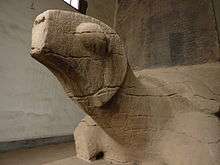
- Lion Garden in Suzhou
- Grand Buddha at Ling Shan, Wuxi
- Chaotian Palace
- Gulin Park
- Jiangxin Island
- Night markets
- Qixia Temple in Qixia Mountains
- Swallow Rock in Yanziji
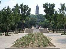
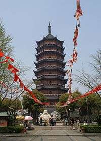
- Tianning Temple Pagoda
- Tombs of Southern Tang Emperor
- Yangzhong Puffer Fish
- Cafe Zeeland
Sports
Professional sports teams in Jiangsu include:
See also
- Major national historical and cultural sites in Jiangsu
- Jiangsu-Hong Kong Personnel Training Cooperation Programme
Notes
- ↑ The data was collected by the Chinese General Social Survey (CGSS) of 2009 and by the Chinese Spiritual Life Survey (CSLS) of 2007, reported and assembled by Xiuhua Wang (2015)[32] in order to confront the proportion of people identifying with two similar social structures: ① Christian churches, and ② the traditional Chinese religion of the lineage (i. e. people believing and worshipping ancestral deities often organised into lineage "churches" and ancestral shrines). Data for other religions with a significant presence in China (deity cults, Buddhism, Taoism, folk religious sects, Islam, et. al.) was not reported by Wang.</ref>
Other religions or not religious people<ref group='note'>This may include:
- Buddhists;
- Confucians;
- Deity worshippers;
- Taoists;
- Members of folk religious sects;
- Small minorities of Muslims;
- And people not bounded to, nor practicing any, institutional or diffuse religion.
References
- ↑ "Communiqué of the National Bureau of Statistics of People's Republic of China on Major Figures of the 2010 Population Census [1] (No. 2)". National Bureau of Statistics of China. 29 April 2011. Retrieved 4 August 2013.
- ↑ "Three provinces lower GDP targets". Chinadaily.com.cn. 2011-02-14. Retrieved 2013-03-26.
- 1 2 "China National Human Development Report 2013" (PDF). United Nations Development Programme. 2013. Retrieved 2014-06-07.
- ↑ http://www.chinadaily.com.cn/bizchina/2014-04/01/content_17393546_2.htm
- ↑ JENNIFER 8. LEE (2009-04-27). "Jiangsu, New York's Chinese Sister". The New York Times. Retrieved 12 September 2014.
- ↑ China provinces ‘to be bigger than Russia’
- ↑ (Chinese) Origin of the Names of China's Provinces, People's Daily Online. (Chinese)
- ↑ Jiangsu History and Cultural life from Britannica
- ↑ (Chinese) 管玉春, 六代繁华帝王都 东晋、南朝的都城——建康 2009-06-24
- ↑ Edward Harper Parker (1903). China, past and present. LONDON: Chapman and Hall, ld. p. 404. Retrieved 2012-02-28.
the lot of both Manchu and Chinese bondsmen. In 1727 the to-min or "idle people" of Cheh Kiang province (a Ningpo name still existing), the yoh-hu or "music people" of Shan Si province, the si-min or "small people" of Kiang Su province, and the tan-ka or "egg-people" of Canton (to this day the boat population there), were all freed from their social disabilities, and allowed to count as free men. So far as my own observations go, after residing for a quarter of a century in half the provinces of China, north, south, east, and west, I should be inclined to describe slavery in China as totally invisible to the naked eye ; personal liberty is absolute where feebleness or ignorance do not expose the subject to the rapacity of mandarins, relatives, or speculators. Even savages and foreigners are welcomed as equals, so long as they conform unreservedly to Chinese custom. On the other hand, the oldfashioned social disabilities of policemen, barbers, and playactors still exist in the eyes of the law, though any idea of caste is totally absent therefrom, and "unofficially" these individuals are as good as any other free men.
- ↑ History about Republic of China from Cultural China
- ↑ "Suzhou -'Venice in the Orient' – China Travel Guide". Uvista.com. Retrieved 2013-03-26.
- ↑ "Nikonians Photo Galleries – Venice of the East". Images.nikonians.org. Retrieved 2013-03-26.
- ↑ List of Major cities of Jiangsu from Jiangsu official Website
- ↑ "中华人民共和国县以上行政区划代码". 中华人民共和国民政部.
- ↑ 深圳市统计局. 《深圳统计年鉴2014》. 深圳统计网. 中国统计出版社. Retrieved 2015-05-29.
- ↑ shi, Guo wu yuan ren kou pu cha ban gong; council, Guo jia tong ji ju ren kou he jiu ye tong ji si bian = Tabulation on the 2010 population census of the people's republic of China by township / compiled by Population census office under the state; population, Department of; statistics, employment statistics national bureau of (2012). Zhongguo 2010 nian ren kou pu cha fen xiang, zhen, jie dao zi liao (Di 1 ban. ed.). Beijing Shi: Zhongguo tong ji chu ban she. ISBN 978-7-5037-6660-2.
- 1 2 "Jiangsu Province: Economic News and Statistics for Jiangsu's Economy". Thechinaperspective.com. Retrieved 2013-03-26.
- ↑ "Country Profile:Jiangsu province -People's Daily Online". English.peopledaily.com.cn. Retrieved 2013-03-26.
- ↑ [The China Perspective http://thechinaperspective.com/articles/jiangsusettoreacha100bphotovoltaicindustry6597/index.html]
- ↑ "Search Results: Economic and Technological Development Zones in Jiangsu". Retrieved 2016-05-10.
- ↑ "1912年中国人口". Retrieved 6 March 2014.
- ↑ "1928年中国人口". Retrieved 6 March 2014.
- ↑ "1936–37年中国人口". Retrieved 6 March 2014.
- ↑ "1947年全国人口". Retrieved 6 March 2014.
- ↑ "中华人民共和国国家统计局关于第一次全国人口调查登记结果的公报". National Bureau of Statistics of China.
- ↑ "第二次全国人口普查结果的几项主要统计数字". National Bureau of Statistics of China.
- ↑ "中华人民共和国国家统计局关于一九八二年人口普查主要数字的公报". National Bureau of Statistics of China.
- ↑ "中华人民共和国国家统计局关于一九九〇年人口普查主要数据的公报". National Bureau of Statistics of China.
- ↑ "现将2000年第五次全国人口普查快速汇总的人口地区分布数据公布如下". National Bureau of Statistics of China.
- ↑ "Communiqué of the National Bureau of Statistics of People's Republic of China on Major Figures of the 2010 Population Census". National Bureau of Statistics of China.
- 1 2 3 China General Social Survey 2009, Chinese Spiritual Life Survey (CSLS) 2007. Report by: Xiuhua Wang (2015, p. 15)
- ↑ Jiangsu road network from Jiangsu Chamber of International Commerce Official Website
- ↑ "2015年江苏省国民经济和社会发展统计公报". Jiangsu Bureau of Statistics.
External links
| Wikimedia Commons has media related to Jiangsu. |
| Wikivoyage has a travel guide for Jiangsu. |
- Jiangsu Government website (Chinese)
- Complete Map of the Seven Coastal Provinces from 1821 to 1850 (English) (Chinese)
 |
Shandong | Yellow Sea | | |
| Anhui | |
|||
| ||||
| | ||||
| Zhejiang | Shanghai East China Sea |
| Provinces | 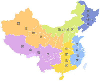 | |
|---|---|---|
| Autonomous regions | ||
| Municipalities | ||
| Special administrative regions | ||
| Other | ||
Note: Taiwan is claimed by the People's Republic of China but administered by the Republic of China (see Political status of Taiwan). Hong Kong and Macau are claimed as provincial-level divisions, but as listed on the constitutional documents and joint declarations their statuses are better to be interpreted as first-level divisions instead. | ||