Jiuzhaigou
| Jiuzhaigou 九寨沟 | |
|---|---|
|
IUCN category III (natural monument or feature) | |
|
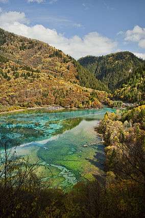
Five Flower Lake | |
 | |
| Location | Jiuzhaigou County, Sichuan |
| Nearest city | Songpan |
| Coordinates | 33°12′N 103°54′E / 33.200°N 103.900°ECoordinates: 33°12′N 103°54′E / 33.200°N 103.900°E |
| Area | 600 to 720 km² |
| Established | 1978 |
| Visitors | 1,190,000 (in 2002) |
| Governing body | Sichuan Provincial Commission for Construction |
| Official name |
Jiuzhaigou Valley Scenic and Historic Interest Area 九寨沟风景名胜区[1] |
| Type | Natural |
| Criteria | vii |
| Designated | 1992 (16th session) |
| Reference no. | 637 |
| State Party | China |
| Region | Asia-Pacific |
| Jiuzhaigou | |||||||||||||||||||||||||
|
"Valley of Nine Fortified Villages (Jiuzhaigou)" in Simplified Chinese (top), Traditional Chinese (middle), and Tibetan (bottom) characters | |||||||||||||||||||||||||
| Chinese name | |||||||||||||||||||||||||
|---|---|---|---|---|---|---|---|---|---|---|---|---|---|---|---|---|---|---|---|---|---|---|---|---|---|
| Simplified Chinese | 九寨沟 | ||||||||||||||||||||||||
| Traditional Chinese | 九寨溝 | ||||||||||||||||||||||||
| Literal meaning | "Valley of Nine Fortified Villages" | ||||||||||||||||||||||||
| |||||||||||||||||||||||||
| Tibetan name | |||||||||||||||||||||||||
| Tibetan | གཟི་རྩ་སྡེ་དགུ། | ||||||||||||||||||||||||
| |||||||||||||||||||||||||
.svg.png)
Jiuzhaigou (pronounced [tɕi̯òu̯ʈʂâi̯kóu̯]; Chinese: 九寨沟; literally: "Valley of Nine Fortified Villages"; Tibetan: གཟི་རྩ་སྡེ་དགུ།, ZYPY: Sirza Degu ) is a nature reserve and national park located in the north of Sichuan province, China.
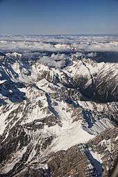
Jiuzhaigou Valley is part of the Min Mountains on the edge of the Tibetan Plateau and stretches over 72,000 hectares (180,000 acres). It is known for its many multi-level waterfalls, colorful lakes, and snow-capped peaks. Its elevation ranges from 2,000 to 4,500 metres (6,600 to 14,800 ft).
Jiuzhaigou Valley was inscribed by UNESCO as a World Heritage Site in 1992 and a World Biosphere Reserve in 1997. It belongs to the category V (Protected Landscape) in the IUCN system of protected area categorization.
History

Jiuzhaigou (literally "Nine Village Valley") takes its name from the nine Tibetan villages along its length.
The remote region was inhabited by various Tibetan and Qiang peoples for centuries. Until 1975 this inaccessible area was little known.[2] Extensive logging took place until 1979, when the Chinese government banned such activity and made the area a national park in 1982. An Administration Bureau was established and the site officially opened to tourism in 1984; layout of facilities and regulations were completed in 1987.
The site was inscribed by UNESCO as a World Heritage Site in 1992 and a World Biosphere Reserve in 1997. The tourism area is classified as a AAAAA scenic area by the China National Tourism Administration.[3]
Since opening, tourist activity has increased every year: from 5,000 in 1984 to 170,000 in 1991, 160,000 in 1995, to 200,000 in 1997, including about 3,000 foreigners. Visitors numbered 1,190,000 in 2002.[4] As of 2004, the site averages 7,000 visits per day, with a quota of 12,000 being reportedly enforced during high season.[2] The Town of Zhangzha at the exit of the valley and the nearby Songpan County feature an ever-increasing number of hotels, including several luxury five-stars, such as Sheraton.
Developments related to mass tourism in the region have caused concerns about the impact on the environment around the park.[5]
Population
Seven of the nine Tibetan villages are still populated today. The main agglomerations that are readily accessible to tourists are Heye, Shuzheng and Zechawa along the main paths that cater to tourists, selling various handicrafts, souvenirs and snacks. There is also Rexi in the smaller Zaru Valley and behind Heye village are Jianpan, Panya and Yana villages. Guodu and Hejiao villages are no longer populated.
Penbu, Panxing and Yongzhu villages lie along the road that passes through the town of Jiuzhaigou/Zhangza outside the valley.
In 2003, the permanent population of the valley was about 1,000 comprising 112 families,[2] and due to the protected nature of the park, agriculture is no longer permitted so the locals now rely on tourism and local government subsidies to make a living.

Geography and climate

Jiuzhaigou lies at the southern end of the Minshan mountain range, 330 km (205 mi) north of the provincial capital of Chengdu. It is part of the Jiuzhaigou County (formerly Nanping County) in the Aba Tibetan Qiang Autonomous Prefecture of northwestern Sichuan province, near the Gansu border.
The valley covers 720 km2 (278 sq mi), with buffer zones covering an additional 600 km2 (232 sq mi). Its elevation, depending on the area considered, ranges from 1,998 to 2,140 m (at the mouth of Shuzheng Gully) to 4,558-4,764 m (on Mount Ganzigonggai at the top of Zechawa Gully).
The climate is subtropical to temperate monsoon with a mean annual temperature of 7.8 °C, with means of −3.7 °C in January and 16.8 °C in July.[2] Total annual rainfall is 761 mm but in the cloud forest it is at least 1,000 mm.[2] 80% of rainfall occurs between May and October.[2]
Ecology

Jiuzhaigou's ecosystem is classified as temperate broad-leaf forest and woodlands, with mixed mountain and highland systems. Nearly 300 km2 (116 sq mi) of the core scenic area are covered by virgin mixed forests. Those forests take on attractive yellow, orange and red hues in the autumn, making that season a popular one for visitors. They are home to a number of plant species of interest, such as endemic varieties of rhododendron and bamboo.
Local fauna includes the endangered giant panda and golden snub-nosed monkey. Both populations are very small (fewer than 20 individuals for the pandas) and isolated. Their survival is in question in a valley subject to increasing tourism. It is one of only three known locations for the threatened Duke of Bedford's vole.[6] Jiuzhaigou is also home to approximately 140 bird species.
Geology and hydrology
Jiuzhaigou's landscape is made up of high-altitude karsts shaped by glacial, hydrological and tectonic activity. It lies on major faultlines on the diverging belt between the Qinghai-Tibet Plate and the Yangtze Plate, and earthquakes have also shaped the landscape. The rock strata is mostly made up of carbonate rocks such dolomite and tufa, as well as some sandstone and shales.
The valley includes the catchment area of three gullies (which due to their large size are often called valleys themselves), and is one of the sources of the Jialing River, part of the Yangtze River system.
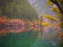
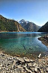
Jiuzhaigou's best-known feature is its dozens of blue, green and turquoise-colored lakes. The local Tibetan people call them "Haizi" in Chinese, meaning "son of the sea". Originating in glacial activity, they were dammed by rockfalls and other natural phenomena, then solidified by processes of carbonate deposition. Some lakes have a high concentration of calcium carbonate, and their water is very clear so that the bottom is often visible even at high depths. The lakes vary in color and aspect according to their depths, residues, and surroundings.
Some of the less stable dams and formations have been artificially reinforced, and direct contact with the lakes or other features is forbidden to tourists.
Notable features

Jiuzhaigou is composed of three valleys arranged in a Y shape. The Rize and Zechawa valleys flow from the south and meet at the centre of the site where they form the Shuzheng valley, flowing north to the mouth of the valley. The mountainous watersheds of these gullies are lined with 55 km (34 mi) of roads for shuttle buses, as well as wooden boardwalks and small pavilions. The boardwalks are typically located on the opposite side of the lakes from the road, shielding them from disturbance by passing buses.
Most visitors will first take the shuttle bus to the end of Rize and/or Shuzheng gully, then make their way back downhill by foot on the boardwalks, taking the bus instead when the next site is too distant. Here is a summary of the sites found in each of the gullies:
Rize Valley
The 18-kilometre-long (11 mi) Rize Valley (日则沟, pinyin: Rìzé Gōu) is the south-western branch of Jiuzhaigou. It contains the largest variety of sites and is typically visited first. Going downhill from its highest point, one passes the following sites:
- The Primeval Forest (原始森林 Yuánshǐ Sēnlín) is a preserved ancient woodland. It is fronted by spectacular views of the surrounding mountains and cliffs, including the 500-metre-high, blade-shaped Sword Rock (剑岩 Jiàn Yán).
- Swan Lake (天鹅海, Tiān'é Hǎi) is a 2250-metre-long, 125-metre-wide picturesque lake named for its visiting swans and ducks.
- Grass Lake (草海, Cǎo Hǎi) is a shallow lake covered in intricate vegetation patterns.
- Arrow Bamboo Lake (箭竹海, Jiànzhú Hǎi), covering an area of 170,000 m2, is a shallow lake with a depth of 6 m. It lies at an elevation of 2,618 m, and was a main feature site for the 2002 Chinese film Hero.
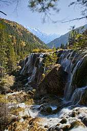
- Panda Lake (熊猫海, Xióngmāo Hǎi) features curious color patterns of blue and green. Giant Pandas were said to have come to this lake to drink, though there have been no sightings for many years. The lake empties into the multi-stream, multi-level Panda Waterfalls, dropping 78 m in three steps.
- Five Flower Lake (五花海, Wǔhuā Hǎi) is a shallow multi-colored lake whose bottom is criss-crossed by ancient fallen tree trunks.
- Pearl Shoal (珍珠滩, Zhēnzhū Tān) is a wide, gently sloping area of active calcareous tufa deposition covered in a thin sheet of flowing water. It empties into the famous Pearl Waterfalls, where the shoal drops 28 m in a 310-metre-wide broad curtain of water. A scene of the television adaptation of Journey to the West was filmed there.
- Mirror Lake (镜海, Jìng Hǎi) is another quiet lake casting beautiful reflections of the surroundings when the water is calm.
Zechawa Valley
The Zechawa Gully (则查洼沟, Zécháwā Gōu) is the south-eastern branch of Jiuzhaigou. It is approximately the same length as Rize gully (18 km) but climbs to a higher altitude (3150 m at the Long Lake). Going downhill from its highest point, it features the following sites:
- Long Lake (长海, Cháng Hǎi) is crescent-shaped and is the highest, largest and deepest lake in Jiuzhaigou, measuring 7.5 km (5 mi) in length and up to 103 m in depth. It reportedly has no outgoing waterways, getting its water from snowmelt and losing it from seepage. Local folklore features a monster in its depths.
- Five-Color Pond (五彩池, Wǔcǎi Chí) is one of the smallest but most spectacular bodies of water in Jiuzhaigou lakes. Despite its very modest dimensions and depth, it has a richly colored underwater landscape with some of the brightest and clearest waters in the area. According to legend, the pond was where Goddess Semo washed her hair and God Dage came daily to bring her water.
- The Seasonal Lakes (季节海, Jìjié Hǎi) are a series of 3 lakes (Lower, Middle and Upper) along the main road, that change from empty to full during each year.
Shuzheng Valley

The Shuzheng Valley (树正沟, Shùzhèng Gōu) is the northern (main) branch of Jiuzhaigou. It ends after 14.5 km (9 mi) at the Y-shaped intersection of the three gullies. Going downhill from the intersection to the mouth of the valley, visitors encounter the following:
- Nuorilang Falls (诺日朗瀑布, Nuòrìlǎng Pùbù), near the junction of the valleys, are 20 m high and 320 m wide. They are reportedly the widest highland waterfall in China, the widest travertine-topped waterfall in the world, and one of the symbols of Jiuzhaigou.
- Nuorilang Lakes (诺日朗群海, Nuòrìlǎng Qúnhǎi) and Shuzheng Lakes (树正群海 Shùzhèng Qúnhǎi) are stepped series of respectively 18 and 19 ribbon lakes formed by the passage of glaciers, then naturally dammed. Some of them have their own folkloric names, such as the Rhinoceros, Unknown, and Tiger lakes.
- Sleeping Dragon Lake (卧龙海, Wòlóng Hǎi) is one of the lower lakes in the area. With a depth of 20 m, it is notable for the clearly visible calcareous dyke running through it, whose shape has been compared to a dragon lying on the bottom.
- Reed Lake (芦苇海, Lúwěi Hǎi) is a 1375-metre-long, reed-covered marsh with a clear turquoise brook (known as the "Jade Ribbon") zigzaging through it. The contrast is particularly striking in the autumn when the reeds turn golden yellow.
Others
- The Fairy Pool (神仙池, Shénxiān Chí) lies 42 km (26 mi) west of Jiuzhaigou and features travertine pools very similar to those of the nearby Huanglong Natural Reserve.
Tourism

The Zharu Valley (扎如沟, Zhārú Gōu) runs southeast from the main Shuzheng gully and is rarely visited by tourists. The valley begins at the Zharu Buddhist monastery and ends at the Red, Black, and Daling lakes.
Zharu Valley is the home of tourism in Jiuzhaigou.[7] The valley has recently been opened to a small number of tourists wishing to go hiking and camping off the beaten track. Visitors can choose from day walks and multiple day hikes, depending on their time availability. Knowledgeable guides accompany tourists through the valley, sharing their knowledge about the unique biodiversity and local culture of the national park. The Zharu Valley has 40% of all the plant species that exist in China and it is the best place to spot wildlife inside the national park.
The main hike follows the pilgrimage of the local Benbo Buddhists circumnavigating the sacred 4,528 m Zha Yi Zha Ga Mountain.[8]
Access
Jiuzhaigou, compared with other high-traffic scenic spots in China, can be difficult to reach by land. The majority of tourists reach the valley by a ten-hour bus ride from Chengdu along the Min River canyon, which is prone to occasional minor rock-slides and, in the rainy season, mudslides that can add several hours to the trip. The new highway constructed along this route was badly damaged during the May 12, 2008 earthquake, but has since been repaired. Further repairs from Mao Xian to Chuan Zhu Si are proceeding, but the road is open to public buses and private vehicles.
Since 2003, it has been possible to fly from Chengdu or Chongqing to Jiuzhai Huanglong Airport on a 3,448-metre-high (11,311 ft) mountain side in Songpan County, and then take an hour-long bus ride to Huanglong, or a 90-minute bus ride to Jiuzhaigou. Since 2006, a daily flight to Xi'an opens in the peak season. In October, 2009, new direct flights were added from Beijing, Shanghai, and Hangzhou. Jiuzhaigou and Huanglong National Parks did not experience any damage during the earthquake of May, 2008, and did not close after the event.
Image gallery
 One of the Lakes
 Pearl Shoal rapids
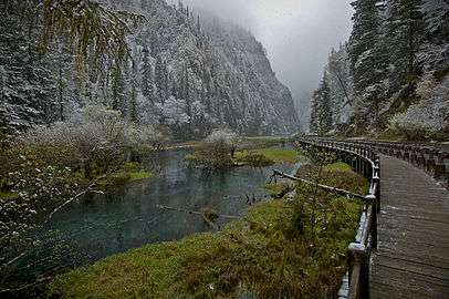 Snowy stream by the mountain pass
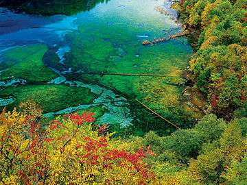 Five Flower Lake
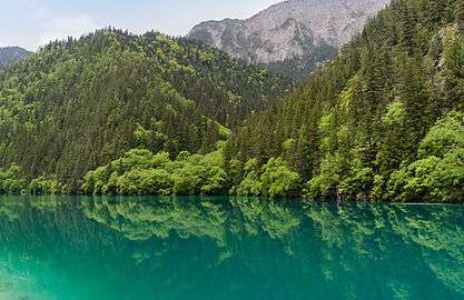 Panda Lake
 Sleeping Dragon Lake
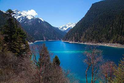 Long Lake
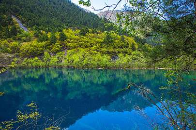 Tiger Lake
See also
- Related places
- Pearl Waterfall
- Huanglong scenic area, south of Jiuzhaigou
- Related lists
References
- ↑ Traditional Chinese: 九寨溝風景名勝區; often abbreviated to: 九寨沟风景区/九寨溝風景區
- 1 2 3 4 5 6 http://www.unep-wcmc.org/medialibrary/2011/06/24/68205af0/Jiuzhaigou%20Valley.pdf
- ↑ "AAAAA Scenic Areas". China National Tourism Administration. 16 November 2008. Retrieved 9 April 2011.
- ↑
- ↑
- ↑ Smith, A.T. & Johnston, C.H. (2008). "Proedromys bedfordi". IUCN Red List of Threatened Species. Version 2008. International Union for Conservation of Nature. Retrieved 10 Jule 2009. Check date values in:
|access-date=(help) Database entry includes a brief justification of why this species is considered to be vulnerable. - ↑ http://www.jiuzhai.com/language/english/ecotourism.html
- ↑ http://www.jiuzhai.com/language/english/info_history.html
- Further reading
- Hoagland, Edward; Yamashita, Michael (March 2009). Johns, Chris, ed. "China's Mystic Waters". National Geographic Magazine. Washington, DC: National Geographic Society. 215 (3): 82–97. ISSN 0027-9358. Retrieved January 7, 2010.
External links
| Wikivoyage has a travel guide for Jiuzhaigou Nature Reserve. |
| Wikimedia Commons has media related to Jiuzhaigou Valley. |
- NGO links
- Jiuzhaigou at the World Heritage Sites of UNESCO
- Jiuzhaigou at the MAB Biosphere Reserves of UNESCO
- Jiuzhaigou at the Terrestrial Ecosystem Monitoring Sites (TEMS) of FAO
- Other links

Sichuan topics | |||||||
|---|---|---|---|---|---|---|---|
| General | |||||||
| History |
| ||||||
| Geography | |||||||
| Culture |
| ||||||
| People | |||||||
| Languages |
| ||||||
| Visitor attractions | |||||||