Taunggyi
| Taunggyi တောင်ကြီးမြို့ | |
|---|---|
|
A view of Taunggyi | |
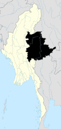
 Taunggyi Location of Taunggyi, Myanmar | |
| Coordinates: 20°47′N 97°02′E / 20.783°N 97.033°E | |
| Country |
|
| Division | Shan State |
| District | Taunggyi District |
| Township | Taunggyi Township |
| Founded | 1894 |
| Elevation | 4,590 ft (1,400 m) |
| Population | |
| • Total | 380,665 |
| • Ethnicities | Tai, Burmese Chinese, Shan, Burmese Indians, Gurkha |
| • Religions | Buddhism, Christianity, Islam |
| Time zone | MST (UTC+6.30) |
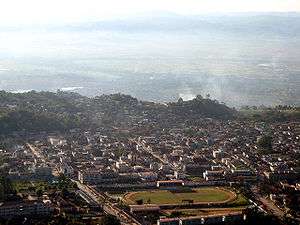
Taunggyi (Burmese: တောင်ကြီးမြို့; MLCTS: taung kri: mrui. [tàʊɴdʑí mjo̰]; Shan: ဝဵင်းတွင်ႇၵျီး [wéŋ tɔ̀ŋ kjí]) is the capital of Shan State, Myanmar. Taunggyi has an estimated population of 380,665 as of 2014,[1] making it the fifth largest city in Myanmar (with Naypyidaw, Bago),[1] and is at an elevation of 4,712 feet (1,436 m) above sea level. The name Taunggyi means "huge mountain" in the Burmese language, and is named after the ridge on the east of the city, part of the Shan Hills system, whose prominent high point is called Taung-chun or "The Spur." Locally this spur is popularly known as Phaya Taung. The ridge has a more prominent and more popular feature known as Chauk Talone, meaning the Craigs.
Recently there has been a flood of Chinese immigrants. Taunggyi lies within the Myelat region of Shan State.
History
Prior to British colonisation, Taunggyi was a small village of a few huts. The area lay on a wide shoulder of the Sittaung Hills of the Shan Hills and was populated by the Shan ethnicity at the time. The signs of the original village of Taunggyi are long gone, but nearby villages can still be discerned quite easily.
During British occupation, the town became the chief city and capital of the Southern Shan States. Taunggyi's modern development began in 1894, when the British moved their administrative offices from Maing Thauk (Fort Stedman) on the eastern shores of Inle Lake to the higher elevation of Taunggyi, for health and geographical reasons. Although geographically within the state of Yawnghwe, the town was denoted as a "notified area" by the British, exempt from the Sawbwa's administration. By 1906, there existed a thousand houses. Because of civil unrest throughout the Shan States during the early 1900s, Taunggyi served as the chief garrison for military police. Taunggyi also served as a supply centre for the Shan States, and catered to persons of many nationalities.
Climate
Taunggyi has a humid subtropical climate (Köppen climate classification Cwa), with subtropical highland climate (Cwb) influence depending on their isotherm they use. There is a winter dry-season (December–March) and a summer wet-season (April–November). Temperatures are warm throughout the year; the winter months (December–February) are milder but the nights can be quite cool.
| Climate data for Taunggyi | |||||||||||||
|---|---|---|---|---|---|---|---|---|---|---|---|---|---|
| Month | Jan | Feb | Mar | Apr | May | Jun | Jul | Aug | Sep | Oct | Nov | Dec | Year |
| Record high °C (°F) | 24.6 (76.3) |
26.7 (80.1) |
29.2 (84.6) |
33.7 (92.7) |
35.2 (95.4) |
32.6 (90.7) |
29.8 (85.6) |
28.5 (83.3) |
25.9 (78.6) |
25.3 (77.5) |
24.1 (75.4) |
21.9 (71.4) |
35.2 (95.4) |
| Average high °C (°F) | 21.9 (71.4) |
24.1 (75.4) |
27.2 (81) |
28.8 (83.8) |
26.7 (80.1) |
24.4 (75.9) |
23.7 (74.7) |
23.4 (74.1) |
24.2 (75.6) |
24.0 (75.2) |
22.8 (73) |
20.8 (69.4) |
24.3 (76.8) |
| Average low °C (°F) | 7.4 (45.3) |
9.1 (48.4) |
12.6 (54.7) |
15.8 (60.4) |
17.1 (62.8) |
17.3 (63.1) |
17.0 (62.6) |
17.1 (62.8) |
16.7 (62.1) |
15.9 (60.6) |
12.2 (54) |
8.2 (46.8) |
13.9 (57.0) |
| Record low °C (°F) | −10 (14) |
−6 (21) |
−3 (27) |
0 (32) |
3.0 (37.4) |
7.8 (46) |
10.3 (50.5) |
12.3 (54.1) |
11.7 (53.1) |
4.2 (39.6) |
−8.9 (16) |
−15 (5) |
−15 (5) |
| Average precipitation mm (inches) | 5 (0.2) |
5 (0.2) |
7 (0.28) |
51 (2.01) |
166 (6.54) |
217 (8.54) |
230 (9.06) |
303 (11.93) |
281 (11.06) |
200 (7.87) |
76 (2.99) |
11 (0.43) |
1,552 (61.11) |
| Source: HKO (1961–1990)[2] | |||||||||||||
Transportation
The main access to Taunggyi is by the mountainous road. A railway line that passes through Taunggyi was recently built in 1995, but at the moment it offers no passenger service to Taunggyi. Regular railway passenger service to the rest of the country is through the town of Shwenyaung, 12 miles (19 km) to the west. The nearest airport is Heho Airport, 24 mi (39 km) about an hour driving distance, by road to the west of Taunggyi.
Culture
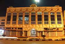
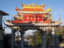

Taunggyi is the melting pot for the Myelat area of the Shan State. Like in most of Myanmar, influence of Buddhism is most evidenced by the monasteries scattered throughout the city. However, being a relatively new city, the monasteries are not of historical significance and architecturally not unique. There is also a significant Christian population, as the center of the Roman Catholic Archdiocese of Taunggyi the St. Joseph's Cathedral and its associated seminary are the main facilities, as well as a Baptist church, both established by early missionaries. There is also a smaller Anglican church, which originally served the British administrators, but recently it has fallen into a state of disrepair. Four mosques serve the Muslim population of the city, Myo Oo Pali, A Lae Pali and Taung Pali are for large population of Burmese Muslims, and Panthay Pali for the Chinese Panthay Muslims. There are also a few temples serving the Chinese Buddhist community.
The Taunggyi area is a popular tourist destination. The city itself has an interesting five-day market, where farmers from around the area would come to the Taunggyi on market day and sell fresh produce in the open market, but with more development of the city, the significance of market day has been lessened. However, the market-day tradition continues strong in the outlying small towns. Nearby, Inle Lake is the home of the unique Intha culture. Inlay is famous for its traditional crafts industry and floating markets that are accessible via traditional longboats. The drive to the Pindaya Caves provides a good view of the Myelat country. Near Taunggyi, in Kekku ကကၠဴ, one can see the local pagoda, whose hundreds of stupas date back to 16th century.
There is no significant industry in Taunggyi. It used to be the trans-shipment point for many of the agricultural products of southern Shan State. However, due to recently imposed zoning regulations, most of these operations have been moved to the surrounding new town of Ayetharyar.
Being the capital of the Shan State, Taunggyi hosts many government offices. There is a museum in town which has displays on the Shan culture, as well as items of historical interest, such as belongings of the Sawbwas. The city is also the headquarters of Eastern Command of the Tatmadaw (Burmese Army), and the army occupies a significant portion of the north-east area of the city.
The city is home to the Taunggyi Education College, University of Computer Stdies,Taunggyi and Taunggyi University.
Shan State Cultural Museum -the state museum lies in Taunggyi.
After 1990s, Chinese migrants are settling in Taunggyi and now they constitute the considerable proportion in communities. The government fails to detect the illegal migration and to investigate the immigration officers who are approving their faked nationality.That enhances the more migration of Chinese from china through eastern part of Shan state.
Notes
- 1 2 http://data.un.org/Data.aspx?d=POP&f=tableCode%3A240. Missing or empty
|title=(help) - ↑ "Climatological Information for Taunggyi, Myanmar". Hong Kong Observatory. Retrieved January 12, 2013.
References
 This article incorporates text from a publication now in the public domain: Chisholm, Hugh, ed. (1911). "article name needed". Encyclopædia Britannica (11th ed.). Cambridge University Press.
| Wikimedia Commons has media related to Taunggyi. |
Capital: Taunggyi | |
|

Coordinates: 20°47′01.08″N 97°02′07.30″E / 20.7836333°N 97.0353611°E