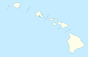
Hawaii Route 560
| ||||
|---|---|---|---|---|
| Kuhio Highway | ||||
| Route information | ||||
| Maintained by HDOT | ||||
| Length: | 10.0 mi (16.1 km) | |||
| Existed: | Late 1960s – present | |||
| Major junctions | ||||
| East end: |
| |||
| West end: | Dead ends at Ha'ena State Park | |||
| Highway system | ||||
| ||||
|
Kaua'i Belt Road--North Shore section | ||||
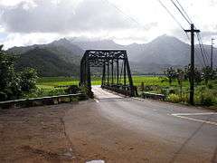
|
Bridge over Hanalei River | ||||
 | ||||
| Location | HI 560, Princeville, Hawaii | |||
| Coordinates | 22°12′43″N 159°31′40″W / 22.21194°N 159.52778°W | |||
| Built | 1900 | |||
| Architect | J.H. Moragne, R.L. Garlinghouse, et al. | |||
| NRHP Reference # | 03001048[1] | |||
| Added to NRHP | February 11, 2004 | |||

Route 560 or Kaua'i Belt Road-North Shore section, is a ten-mile (16 km) scenic road on the northern shore of the island of Kauaʻi in Hawaii. The entire belt road is signed as the Kuhio Highway and Hawaii Route 56 was once signed on this route before it was downgraded to become Hawaii Route 560 in the late 1960s.[2] The Kuhio Highway is named after Jonah Kūhiō Kalaniana'ole, the second non-voting Congressional Delegate from territorial Hawaii.
Route
Kuhio Highway ends its Route 56 designation in Princeville at 22°12′46″N 159°28′17″W / 22.21278°N 159.47139°W. The road drops in elevation heading towards the Hanalei River with lookout points giving breathtaking views of the river valley and the northwestern shore of Kauaʻi. It then goes through the only major town on this route Hanalei, and past the Hanalei Bay. It follows a foot trail used by ancient Hawaiians. An early record is given in the 1849 diary of William DeWitt Alexander, who lived at the Waiʻoli mission which still can be seen along the road. William Tufts Brigham recorded boats used to cross the rivers in 1865. The Hanalei Pier is just north of the road on the bay. At one time the valley was home to rice fields, and the Haraguchi Rice Mill is one of several built along the river.[3]
The road is narrow at times and features eleven one-lane bridges with the first five constructed in 1912. County engineers J. H. Moragne and R. L. Garlinghouse supervised building the bridges and paving through the 20th century.[3]
Many of these bridges have restricted weight limits and some of them are wooden.[4] Traffic must yield at these bridges and it is custom to allow the greater traffic to cross first or after five to seven cars have passed your side of the road to allow to the other side to pass.[5] The road becomes narrower with each passing mile as the Nā Pali Coast begins to inch closer towards the coast. The road dead ends at Haʻena State Park.
Past aspirations
There were plans to extend the road to Route 550 allowing one to circumnavigate the entire island in the 1960s; however, those plans were dropped due to environmental concerns and lack of traffic demand.[6] The Hawaii Department of Transportation was planning to replace these bridges with two-lane bridges, but the plan was later abandoned in 1987. The area is popular for films, although they can cause traffic congestion since there are no alternate routes.[7]
Preservation
Instead, a massive renovation project began for the Hanalei River bridge, promoted by a community preservation group with cooperation of the Hawaii Department of Transportation. A Pratt truss was built as a replica of the original 1912 one-lane structure.[8] The new bridge was officially dedicated in November 2003. A 1960s structure under the roadway supports the heavier weight of modern traffic.[9] Route 560 was added February 11, 2004 to the National Register of Historic Places listings in Hawaii as site 03001048.[1]
See also
- Contributing property
- Cultural landscape
- Historic preservation
- Keeper of the Register
- List of heritage registers
- Property type (National Register of Historic Places)
- United States National Register of Historic Places listings
- State Historic Preservation Office
References
- 1 2 National Park Service (2009-03-13). "National Register Information System". National Register of Historic Places. National Park Service.
- ↑ How did Hawaii's route number system evolve into its present form?
- 1 2 Dawn E. Duensing (April 8, 2002). "Kaua'i Belt Road (North Shore section) nomination form" (PDF). National Register of Historic Places. U.S. National Park Service. Retrieved 2010-04-30.
- ↑ HI 560 Bridge Log
- ↑ One Lane Bridge Crossing the Hanalei River
- ↑ Why can't you drive all the way around Kauai?
- ↑ "Bad timing cited for filming in Hanalei". Kauai Garden Island News. April 23, 2010.
- ↑ Chris Cook (May 15, 2003). "Robeson, Wilcox honored for preserving Hanalei Bridge". Kauai Garden Island News. Retrieved 2010-04-30.
- ↑ "Renovated Hanalei Bridge officially blessed". Kauai Garden Island News. November 9, 2003.
External links
| Topics | |
|---|---|
| Lists by states |
|
| Lists by insular areas | |
| Lists by associated states | |
| Other areas | |
| |