Keedysville Historic District
|
Keedysville Historic District | |
|
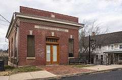
Former Keedysville Bank, now the town hall | |
  | |
| Location | Along Main St., Keedysville, Maryland |
|---|---|
| Coordinates | 39°29′12″N 77°41′56″W / 39.48667°N 77.69889°WCoordinates: 39°29′12″N 77°41′56″W / 39.48667°N 77.69889°W |
| Area | 80 acres (32 ha) |
| Built | 1768 |
| Architectural style | Greek Revival, Italianate, et al. |
| NRHP Reference # | 01001183[1] |
| Added to NRHP | October 26, 2001 |
Keedysville Historic District is a national historic district at Keedysville, Washington County, Maryland, United States. The district boundary is within the corporate limits of the town, generally focused on the properties lining Main Street and those associated with the now-abandoned railroad facilities. It is reflective of the town's growth from the 1768 establishment of Jacob Hess' mill along the old Conococheague migration road to expansion with each new transportation development. The first major development was the Boonsboro-Sharpsburg turnpike. With the advent of the Baltimore and Ohio Railroad through the center of town, shops and manufactures were established and expanded. The town's prosperity waned with the loss of railroad service in 1953. The district is also significant for the wide range of architectural stylistic influences present on the buildings through the historic town.[2]
The district was added to the National Register of Historic Places in 2001.[1]
References
- 1 2 National Park Service (2010-07-09). "National Register Information System". National Register of Historic Places. National Park Service.
- ↑ Paula S. Reed and Edie Wallace (January 2001). "National Register of Historic Places Registration: Keedysville Historic District" (PDF). Maryland Historical Trust. Retrieved 2016-01-01.
External links
- Keedysville Historic District, Washington County, including photo from 2001, at Maryland Historical Trust
- Boundary Map of the Keedysville Historic District, Washington County, at Maryland Historical Trust
| Topics |   | |
|---|---|---|
| Lists by county | ||
| Lists by city | ||
| Other lists | ||
| ||