| [2] |
Name on the Register |
Image |
Date listed[3] |
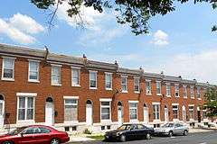
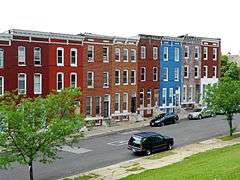
Location |
District[4] |
Description |
|---|
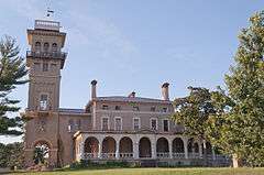
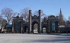
| 1 |
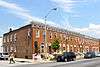
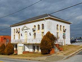
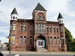
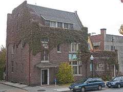
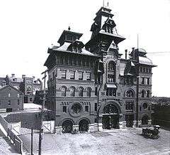
American Brewery |
|
000000001973-05-09-0000May 9, 1973
(#73002179) |
1701 N. Gay St.
39°18′34″N 76°35′06″W / 39.309444°N 76.585°W / 39.309444; -76.585 (American Brewery) |
East |
|
| 2 |
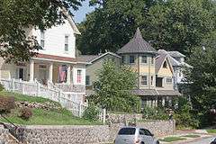
Arcadia-Beverly Hills Historic District |
|
000000002004-12-23-0000December 23, 2004
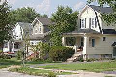
(#04001375) |
Moravia Rd.-Belair Rd.-Herring Run Park-Harford Rd.
39°20′13″N 76°34′06″W / 39.336944°N 76.568333°W / 39.336944; -76.568333 (Arcadia-Beverly Hills Historic District) |
Northeast |
|
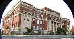
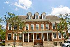
| 3 |
Baltimore City College |
|
000000002003-06-30-0000June 30, 2003
(#03000573) |
3320 The Alameda
39°19′17″N 76°35′46″W / 39.321389°N 76.596111°W / 39.321389; -76.596111 (Baltimore City College) |
Northeast |
|
| 4 |
Baltimore East/South Clifton Park Historic District |
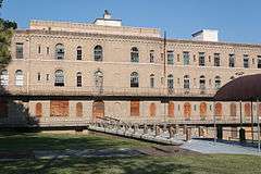
|
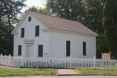
000000002002-12-27-0000December 27, 2002
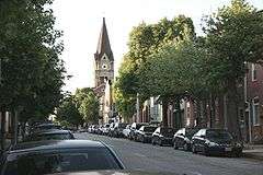
(#02001611) |
Roughly bounded by Clifton Park, N. Broadway, E. Chase St., and N. Rose St.
39°18′33″N 76°35′22″W / 39.309167°N 76.589444°W / 39.309167; -76.589444 (Baltimore East/South Clifton Park Historic District) |
East |
|
| 5 |
Berea-Biddle Street Historic District |
Upload image |
000000002014-12-29-0000December 29, 2014
(#14001092) |
N. Rose, & Federal Sts., Edison Hwy., PCRR.
39°18′18″N 76°34′43″W / 39.305°N 76.5785°W / 39.305; -76.5785 (Berea-Biddle Street Historic District) |
East |
|
| 6 |
Bohemian National Cemetery |
|
000000002010-11-10-0000November 10, 2010
(#10000910) |
1300 Horners Lane
39°18′28″N 76°33′13″W / 39.307778°N 76.553611°W / 39.307778; -76.553611 (Bohemian National Cemetery) |
East |
|
| 7 |
Brewers Hill Historic District |
Upload image |
000000002014-12-22-0000December 22, 2014
(#14001070) |
Roughly bounded by Eastern Ave., S. Conkling, S. Haven & Dillon Sts.
39°17′02″N 76°33′53″W / 39.2839°N 76.5647°W / 39.2839; -76.5647 (Brewers Hill Historic District) |
East |
|
| 8 |
Clifton Park |
|
000000002007-09-12-0000September 12, 2007
(#07000941) |
Bounded by Hartford Rd., Erdman Ave., Clifton Park Terrace, the Baltimore Belt Line, and Sinclair Ln.
39°19′15″N 76°34′58″W / 39.320858°N 76.582831°W / 39.320858; -76.582831 (Clifton Park) |
East |
|
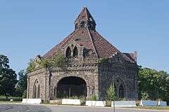
| 9 |
Clifton Park Valve House |
|
000000001971-02-18-0000February 18, 1971
(#71001034) |
2801 Harford Rd.
39°19′09″N 76°35′13″W / 39.319167°N 76.586944°W / 39.319167; -76.586944 (Clifton Park Valve House) |
Northeast |
|
| 10 |
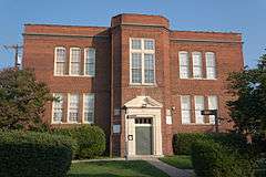
Clifton School |
|
000000001982-12-16-0000December 16, 1982
(#82001583) |
2670 Kennedy Ave.
39°19′18″N 76°35′46″W / 39.321667°N 76.596111°W / 39.321667; -76.596111 (Clifton School) |
Northeast |
|
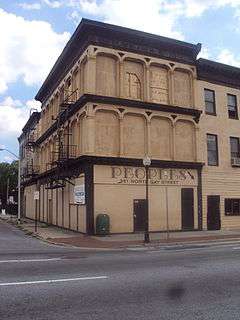
| 11 |
Coca-Cola Bottling Company of Baltimore Building |
Upload image |
000000002013-10-23-0000October 23, 2013
(#13000847) |
2525 Kirk Ave.
39°19′08″N 76°36′01″W / 39.318994°N 76.600199°W / 39.318994; -76.600199 (Coca-Cola Bottling Company of Baltimore Building) |
East |
|
| 12 |
Coldstream Homestead Montebello Historic District |
Upload image |
000000002013-10-23-0000October 23, 2013
(#13000848) |
Roughly bounded by The Alameda, Kennedy & Kirk Aves., Harford Rd., E. 32nd & E. 33rd Sts.
39°19′19″N 76°35′36″W / 39.321948°N 76.593246°W / 39.321948; -76.593246 (Coldstream Homestead Montebello Historic District) |
East |
|
| 13 |
East Monument Historic District |
|
000000002009-12-08-0000December 8, 2009
(#09001061) |
N. Washington St. on the west, an Amtrak rail line on the north to East St., south to Monument, and east to Highland Ave.
39°18′02″N 76°34′48″W / 39.300544°N 76.579944°W / 39.300544; -76.579944 (East Monument Historic District) |
Northeast |
|
| 14 |
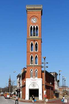
Engine House No. 6 |
|
000000001973-06-18-0000June 18, 1973
(#73002185) |
416 N. Gay St.
39°17′43″N 76°36′20″W / 39.295278°N 76.605556°W / 39.295278; -76.605556 (Engine House No. 6) |
East |
|
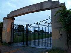
| 15 |
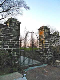
Friends Burial Ground |
|
000000002005-01-12-0000January 12, 2005
(#04001471) |
2506 Harford Rd.
39°19′05″N 76°35′42″W / 39.318056°N 76.595°W / 39.318056; -76.595 (Friends Burial Ground) |
Northeast |
|
| 16 |
Green Mount Cemetery |
|
000000001980-04-02-0000April 2, 1980
(#80001786) |
Bounded by North and Greenmount Aves. and Ensor and Hoffman Sts.
39°18′31″N 76°36′24″W / 39.308611°N 76.606667°W / 39.308611; -76.606667 (Green Mount Cemetery) |
East |
|
| 17 |
Gompers School |
|
000000001985-06-20-0000June 20, 1985
(#85001272) |
1701 E. North Ave.
39°18′43″N 76°35′41″W / 39.311944°N 76.594722°W / 39.311944; -76.594722 (Gompers School) |
East |
|
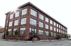
| 18 |
L. Grief and Bro., Inc. Manufactory |
|
000000002007-12-19-0000December 19, 2007
(#07001284) |
901 N. Milton Ave.
39°18′05″N 76°34′57″W / 39.301389°N 76.5825°W / 39.301389; -76.5825 (L. Grief and Bro., Inc. Manufactory) |
East |
|
| 19 |
Gunther Brewing Company |
|
000000002002-12-26-0000December 26, 2002
(#02001607) |
1200, 1211, and 1301 S. Conkling St., 3601 and 3701 O'Donnell St., the eastern side of S. Conkling St., and the rear eastern side of S. Conkling St.
39°16′46″N 76°34′00″W / 39.2795°N 76.566706°W / 39.2795; -76.566706 (Gunther Brewing Company) |
East |
|
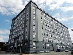
| 20 |
Industrial Building |
|
000000001980-03-10-0000March 10, 1980
(#80001788) |
501 E. Preston St.
39°18′16″N 76°36′31″W / 39.304444°N 76.608611°W / 39.304444; -76.608611 (Industrial Building) |
East |
|
| 21 |
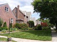
Lauraville Historic District |
|
000000002001-12-28-0000December 28, 2001
(#01001371) |
Roughly bounded by Harford Rd., Herring Run Creek, Cold Spring Ln., Charlton Ave., Halcyon Ave., Grindon Rd., and Echodale Ave.
39°20′44″N 76°34′23″W / 39.345556°N 76.573056°W / 39.345556; -76.573056 (Lauraville Historic District) |
Northeast |
|
| 22 |
Mayfield Historic District |
|
000000002004-01-06-0000January 6, 2004
(#03001371) |
Lake Montebello Rd.-Chesterfield Ave.,-Crossland Ave.-Erdman Ave.
39°19′49″N 76°34′48″W / 39.330278°N 76.58°W / 39.330278; -76.58 (Mayfield Historic District) |
Northeast |
|
| 23 |
McDonogh Place Historic District |
Upload image |
000000002015-04-28-0000April 28, 2015
(#15000172) |
N. Broadway, E. Eager, McDonogh & E. Chase Sts.
39°18′10″N 76°35′39″W / 39.3028°N 76.5941°W / 39.3028; -76.5941 (McDonogh Place Historic District) |
East |
|
| 24 |
North Central Historic District |
|
000000002002-12-27-0000December 27, 2002
(#02001606) |
Roughly bounded by North Ave., Greenmount Ave., Falls Rd., and Interstate 83
39°18′34″N 76°36′48″W / 39.309444°N 76.613333°W / 39.309444; -76.613333 (North Central Historic District) |
East |
|
| 25 |
Null House |
|
000000001983-01-27-0000January 27, 1983
(#83002936) |
1037 Hillen St.
39°17′46″N 76°36′22″W / 39.296111°N 76.606111°W / 39.296111; -76.606111 (Null House) |
East |
|
| 26 |
Oak Street Garage |
Upload image |
000000002013-10-23-0000October 23, 2013
(#13000849) |
2600 N. Howard St.
39°19′10″N 76°37′14″W / 39.319392°N 76.620455°W / 39.319392; -76.620455 (Oak Street Garage) |
East |
|
| 27 |
Old East Baltimore Historic District |
|
000000002006-12-27-0000December 27, 2006
(#06001175) |
Generally bounded by Jones Falls, Greenmount Cemetery, North Ave., Broadway, and Madison, Ashland and Eager Sts.
39°18′19″N 76°36′16″W / 39.305278°N 76.604444°W / 39.305278; -76.604444 (Old East Baltimore Historic District) |
East |
|
| 28 |
Old Hamilton Library |
|
000000002012-09-25-0000September 25, 2012
(#12000817) |
3006 Hamilton Ave.
39°21′06″N 76°33′39″W / 39.351796°N 76.560869°W / 39.351796; -76.560869 (Old Hamilton Library) |
Northeast |
|
| 29 |
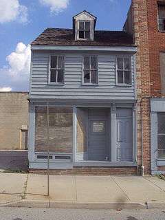
Old Town Savings Bank |
|
000000001996-05-09-0000May 9, 1996
(#96000470) |
353 N. Gay St.
39°17′40″N 76°36′24″W / 39.294444°N 76.606667°W / 39.294444; -76.606667 (Old Town Savings Bank) |
East |
part of the Cast Iron Architecture of Baltimore MPS
|
| 30 |
Public School No. 37 |
|
000000001979-09-25-0000September 25, 1979
(#79001112) |
E. Biddle St. and N. Patterson Park Ave.
39°18′16″N 76°35′08″W / 39.304444°N 76.585556°W / 39.304444; -76.585556 (Public School No. 37) |
East |
|
| 31 |
Public School No. 99 |
|
000000001979-09-25-0000September 25, 1979
(#79001113) |
E. North Ave. and N. Washington St.
39°18′46″N 76°35′25″W / 39.312778°N 76.590278°W / 39.312778; -76.590278 (Public School No. 99) |
East |
|
| 32 |
Public School No. 109 |
Upload image |
000000001979-09-25-0000September 25, 1979
(#79001110) |
N. Broadway and Ashland Ave.
39°18′01″N 76°35′38″W / 39.3003°N 76.5940°W / 39.3003; -76.5940 (Public School No. 109) |
East |
|
| 33 |
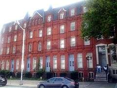
Rowhouses at 303-327 East North Avenue |
|
000000001984-09-13-0000September 13, 1984
(#84001351) |
303-327 E. North Ave.
39°18′40″N 76°36′43″W / 39.311111°N 76.611944°W / 39.311111; -76.611944 (Rowhouses at 303-327 East North Avenue) |
East |
|
| 34 |
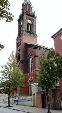
St. James the Less Roman Catholic Church |
|
000000001982-03-15-0000March 15, 1982
(#82004750) |
Aisquith St. at Eager St.
39°18′04″N 76°36′08″W / 39.301111°N 76.602222°W / 39.301111; -76.602222 (St. James the Less Roman Catholic Church) |
East |
|
| 35 |
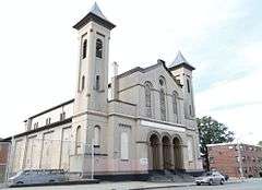
St. John the Evangelist Roman Catholic Church |
|
000000001982-03-15-0000March 15, 1982
(#82004751) |
901 E. Eager St.
39°18′05″N 76°36′17″W / 39.301389°N 76.604722°W / 39.301389; -76.604722 (St. John the Evangelist Roman Catholic Church) |
East |
|
| 36 |
Hans Schuler Studio and Residence |
|
000000001985-09-27-0000September 27, 1985
(#85002510) |
5 East Lafayette Ave.
39°18′34″N 76°36′57″W / 39.309583°N 76.615833°W / 39.309583; -76.615833 (Hans Schuler Studio and Residence) |
East |
|
| 37 |
Sydenham Hospital for Communicable Diseases |
|
000000001998-10-30-0000October 30, 1998
(#98001294) |
Argonne Dr., west of Herring Rd.
39°20′16″N 76°34′52″W / 39.337778°N 76.581111°W / 39.337778; -76.581111 (Sydenham Hospital for Communicable Diseases) |
Northeast |
|
| 38 |
Taylor's Chapel |
|
000000001983-07-28-0000July 28, 1983
(#83002940) |
6001 Hillen Rd., Mount Pleasant Park
39°21′46″N 76°34′40″W / 39.362778°N 76.577778°W / 39.362778; -76.577778 (Taylor's Chapel) |
Northeast |
|
| 39 |
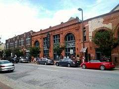
Upper Fells Point Historic District |
|
000000002007-12-20-0000December 20, 2007
(#07001034) |
Roughly bounded by E. Baltimore St., S. Chapel St., E. Pratt St., S. Patterson Park Ave., and S. Chester, Gough, and S. Bethel Sts.
39°17′19″N 76°35′16″W / 39.288636°N 76.587833°W / 39.288636; -76.587833 (Upper Fells Point Historic District) |
East |
|
.jpg)