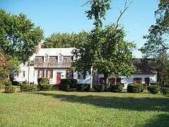
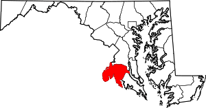
| [3] |
Name on the Register[4] |
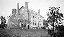
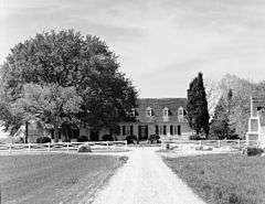
Image |
Date listed[5] |
Location |
City or town |
Description |
|---|
| 1 |
Acquinsicke |
Upload image |
000000001992-02-20-0000February 20, 1992
(#92000070) |
Billingsley Rd. west of its junction with Maryland Route 228
38°36′30″N 77°02′14″W / 38.608333°N 77.037222°W / 38.608333; -77.037222 (Acquinsicke) |
Pomfret |
|
| 2 |
Araby |
|
000000001974-07-25-0000July 25, 1974
(#74000947) |
Southeast of Mason on Maryland Route 425
38°34′43″N 77°06′54″W / 38.578611°N 77.115°W / 38.578611; -77.115 (Araby) |
Mason's Springs |
|
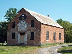
| 3 |
Bryantown Historic District |
|
000000001985-03-14-0000March 14, 1985
(#85000590) |
Maryland Route 5 and County Route 232
38°33′11″N 76°50′39″W / 38.553056°N 76.844167°W / 38.553056; -76.844167 (Bryantown Historic District) |
Bryantown |
|
| 4 |
Cedar Grove |
Upload image |
000000001979-03-02-0000March 2, 1979
(#79001124) |
South of La Plata off Maryland Route 6 west of Blossom Point Rd.
38°28′50″N 77°04′22″W / 38.480556°N 77.072778°W / 38.480556; -77.072778 (Cedar Grove) |
La Plata |
|
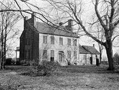
| 5 |
Ellerslie |
|
000000001979-09-24-0000September 24, 1979
(#79003264) |
West of Port Tobacco on Maryland Route 6
38°30′20″N 77°02′29″W / 38.505556°N 77.041389°W / 38.505556; -77.041389 (Ellerslie) |
Port Tobacco |
|
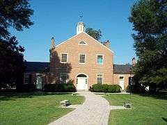
| 6 |
The Exchange |
Upload image |
000000001984-06-07-0000June 7, 1984
(#84001763) |
7310 Greenland Place
38°30′54″N 76°58′23″W / 38.515°N 76.973056°W / 38.515; -76.973056 (The Exchange) |
La Plata |
|
| 7 |
Green's Inheritance |
Upload image |
000000001977-12-16-0000December 16, 1977
(#77000692) |
Northeast of Pomfret on Maryland Route 227
38°35′19″N 77°01′13″W / 38.588611°N 77.020278°W / 38.588611; -77.020278 (Green's Inheritance) |
Pomfret |
|
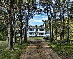
| 8 |
Habre-de-Venture; Thomas Stone National Historic Site |
|
000000001972-10-31-0000October 31, 1972
(#72001595) |
6655 Rose Hill Rd., near its junction with Maryland Routes 6 and 225
38°31′55″N 77°01′53″W / 38.531944°N 77.031389°W / 38.531944; -77.031389 (Habre-de-Venture; Thomas Stone National Historic Site) |
Port Tobacco |
|
| 9 |
The Hermitage |
|
000000001998-07-23-0000July 23, 1998
(#98000886) |
Washington Ave.
38°32′02″N 76°58′52″W / 38.533889°N 76.981111°W / 38.533889; -76.981111 (The Hermitage) |
La Plata |
|
| 10 |
Johnsontown Tobacco Barn No. 2 |
Upload image |
000000002011-12-27-0000December 27, 2011
(#11000947) |
9830 Johnsontown Rd.
38°29′12″N 76°58′17″W / 38.486547°N 76.971419°W / 38.486547; -76.971419 (Johnsontown Tobacco Barn No. 2) |
La Plata vicinity |
part of the Tobacco Barns of Southern Maryland MPS
|
| 11 |
La Grange |
|
000000001976-10-22-0000October 22, 1976
(#76000990) |
Maryland Route 6, west of U.S. Route 301
38°31′27″N 76°59′28″W / 38.524167°N 76.991111°W / 38.524167; -76.991111 (La Grange) |
La Plata |
|
| 12 |
Linden |
|
000000001977-11-23-0000November 23, 1977
(#77000693) |
North of Port Tobacco on Mitchell Rd.
38°33′16″N 77°00′46″W / 38.554444°N 77.012778°W / 38.554444; -77.012778 (Linden) |
Port Tobacco |
|
| 13 |
The Lindens |
|
000000001990-04-23-0000April 23, 1990
(#90000607) |
Maryland Route 488
38°33′07″N 76°52′32″W / 38.551944°N 76.875556°W / 38.551944; -76.875556 (The Lindens) |
Bryantown |
|
| 14 |
Locust Grove |
|
000000001978-07-21-0000July 21, 1978
(#78001454) |
West of La Plata on Maryland Route 225
38°32′32″N 77°01′22″W / 38.542222°N 77.022778°W / 38.542222; -77.022778 (Locust Grove) |
La Plata |
|
| 15 |
Mallows Bay-Widewater Historic and Archeological District |
|
000000002015-04-24-0000April 24, 2015
(#15000173) |
Off Charles County shoreline at Sandy Pt.
38°28′21″N 77°16′07″W / 38.4726°N 77.2686°W / 38.4726; -77.2686 (Mallows Bay-Widewater Historic and Archeological District) |
Nanjemoy vicinity |
|
| 16 |
Marshall Hall |
|
000000001976-05-12-0000May 12, 1976
(#76000152) |
5 miles north of Maryland Routes 210 and 227
38°41′06″N 77°05′55″W / 38.685°N 77.098611°W / 38.685; -77.098611 (Marshall Hall) |
Bryans Road |
|
| 17 |
Maxwell Hall |
Upload image |
000000001974-07-30-0000July 30, 1974
(#74000949) |
East of Patuxent on Teagues Point Rd.
38°32′04″N 76°42′01″W / 38.534444°N 76.700278°W / 38.534444; -76.700278 (Maxwell Hall) |
Patuxent |
|
| 18 |
McPherson's Purchase |
Upload image |
000000001985-01-03-0000January 3, 1985
(#85000019) |
Maryland Route 227
38°35′56″N 77°02′51″W / 38.598889°N 77.0475°W / 38.598889; -77.0475 (McPherson's Purchase) |
Pomfret |
|
| 19 |
Mount Air |
Upload image |
000000001978-12-22-0000December 22, 1978
(#78001453) |
West of Faulkner off U.S. Route 301
38°26′12″N 76°59′50″W / 38.436667°N 76.997222°W / 38.436667; -76.997222 (Mount Air) |
Faulkner |
|
| 20 |
Mount Aventine |
|
000000001996-04-18-0000April 18, 1996
(#94001328) |
1.8 miles southwest of Bryans Rd. on the northwestern side of Chapman's Landing Rd.
38°37′04″N 77°07′03″W / 38.617778°N 77.1175°W / 38.617778; -77.1175 (Mount Aventine) |
Bryans Road |
|
| 21 |
Mt. Carmel Monastery |
|
000000001973-12-04-0000December 4, 1973
(#73000913) |
North of Port Tobacco on Mt. Carmel Rd.
38°33′21″N 77°00′01″W / 38.555833°N 77.000278°W / 38.555833; -77.000278 (Mt. Carmel Monastery) |
Port Tobacco |
|
| 22 |
Oak Grove |
Upload image |
000000001983-11-23-0000November 23, 1983
(#83003777) |
Turkey Hill Rd.
38°35′10″N 76°59′10″W / 38.586111°N 76.986111°W / 38.586111; -76.986111 (Oak Grove) |
La Plata |
|
| 23 |
Oakland |
Upload image |
000000001983-08-04-0000August 4, 1983
(#83002946) |
Maryland Route 5
38°33′30″N 76°48′40″W / 38.558333°N 76.811111°W / 38.558333; -76.811111 (Oakland) |
Bryantown |
|
| 24 |
Pleasant Hill |
Upload image |
000000001997-12-08-0000December 8, 1997
(#97001449) |
9205 Marshall's Corner Rd.
38°35′18″N 76°59′37″W / 38.588333°N 76.993611°W / 38.588333; -76.993611 (Pleasant Hill) |
Pomfret |
|
| 25 |
Port Tobacco Historic District |
|
000000001989-08-04-0000August 4, 1989
(#79003911) |
Off Maryland Route 6
38°30′45″N 77°01′07″W / 38.5125°N 77.018611°W / 38.5125; -77.018611 (Port Tobacco Historic District) |
Port Tobacco |
|
| 26 |
Retreat |
|
000000001988-06-28-0000June 28, 1988
(#88000222) |
Maryland Route 484/Poor House Rd. and Maryland Route 6
38°30′38″N 77°02′48″W / 38.510556°N 77.046667°W / 38.510556; -77.046667 (Retreat) |
Port Tobacco |
|
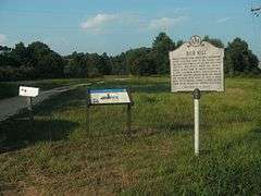
| 27 |
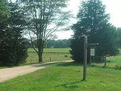
Rich Hill |
|
000000001975-11-12-0000November 12, 1975
(#75000885) |
Northeast of Bel Alton on Bel Alton-Newtown Rd.
38°28′54″N 76°57′03″W / 38.481667°N 76.950833°W / 38.481667; -76.950833 (Rich Hill) |
Bel Alton |
|
| 28 |
Rose Hill |
|
000000001973-03-30-0000March 30, 1973
(#73000914) |
Rose Hill Rd.
38°31′19″N 77°01′42″W / 38.522°N 77.028367°W / 38.522; -77.028367 (Rose Hill) |
Port Tobacco |
|
| 29 |
Rosemary Lawn |
Upload image |
000000001992-04-16-0000April 16, 1992
(#92000380) |
Fire Tower Rd.
38°29′29″N 77°06′17″W / 38.491389°N 77.104722°W / 38.491389; -77.104722 (Rosemary Lawn) |
Welcome |
|
| 30 |
Sarum |
|
000000001974-08-13-0000August 13, 1974
(#74000948) |
Southeast of Newport off Maryland Route 234
38°24′19″N 76°53′42″W / 38.405278°N 76.895°W / 38.405278; -76.895 (Sarum) |
Newport |
|
| 31 |
St. Catharine |
|
000000001974-10-01-0000October 1, 1974
(#74000950) |
East of Waldorf near the junction of Maryland Routes 232 and 382
38°36′34″N 76°49′36″W / 38.609444°N 76.826667°W / 38.609444; -76.826667 (St. Catharine) |
Waldorf |
|
| 32 |
St. Mary's Roman Catholic Church, Newport |
|
000000001991-05-30-0000May 30, 1991
(#91000603) |
St. Mary's Church Rd.
38°25′53″N 76°54′23″W / 38.431389°N 76.906389°W / 38.431389; -76.906389 (St. Mary's Roman Catholic Church, Newport) |
Newport |
|
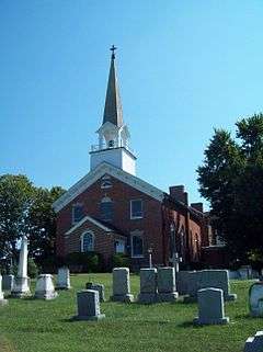
| 33 |
St. Thomas Manor |
|
000000001988-11-10-0000November 10, 1988
(#88002050) |
Maryland Route 427/Chapel Point Rd.
38°27′55″N 77°01′27″W / 38.465278°N 77.024167°W / 38.465278; -77.024167 (St. Thomas Manor) |
Port Tobacco |
|
| 34 |
Spye Park |
Upload image |
000000001990-10-04-0000October 4, 1990
(#90001523) |
Padgett Road
38°35′34″N 76°57′17″W / 38.592778°N 76.954722°W / 38.592778; -76.954722 (Spye Park) |
White Plains |
|
| 35 |
Stagg Hall |
|
000000001988-12-29-0000December 29, 1988
(#88003061) |
County Route 469/Chapel Point Rd.
38°30′42″N 77°01′11″W / 38.511667°N 77.019722°W / 38.511667; -77.019722 (Stagg Hall) |
Port Tobacco |
|
| 36 |
Thainston |
Upload image |
000000001990-03-28-0000March 28, 1990
(#90000436) |
Mitchell Rd., north of Maryland Route 225
38°34′06″N 77°00′35″W / 38.568333°N 77.009722°W / 38.568333; -77.009722 (Thainston) |
La Plata |
|
| 37 |
Timber Neck Farm |
Upload image |
000000001979-09-06-0000September 6, 1979
(#79001123) |
Southeast of Faulkner Rd.
38°25′52″N 76°57′08″W / 38.431111°N 76.952222°W / 38.431111; -76.952222 (Timber Neck Farm) |
Faulkner |
|
| 38 |
Truman's Place |
Upload image |
000000001988-01-20-0000January 20, 1988
(#87002264) |
Gallant Green Rd.
38°33′58″N 76°46′41″W / 38.566111°N 76.778056°W / 38.566111; -76.778056 (Truman's Place) |
Hughesville |
|
| 39 |
Waverley |
|
000000001975-08-11-0000August 11, 1975
(#75000886) |
13535 Waverly Point Road
38°20′19″N 76°57′36″W / 38.338611°N 76.96°W / 38.338611; -76.96 (Waverley) |
Morgantown |
|
.jpg)


.jpg)