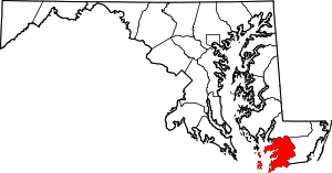
| [3] |
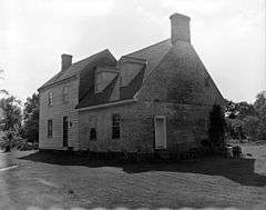
Name on the Register[4] |
Image |
Date listed[5] |
Location |
City or town |
Description |
|---|
| 1 |
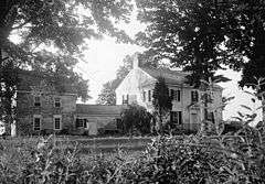
Academy Grove Historic District |
|
000000001984-05-03-0000May 3, 1984
(#84001863) |
Maryland Route 361
38°05′58″N 75°48′32″W / 38.099444°N 75.808889°W / 38.099444; -75.808889 (Academy Grove Historic District) |
Upper Fairmount |
|
| 2 |
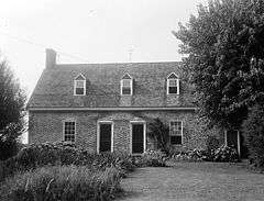
Adams Farm |
Upload image |
000000001988-11-10-0000November 10, 1988
(#88002140) |
Princess Anne-Westover Rd.
38°11′35″N 76°01′48″W / 38.193056°N 76.03°W / 38.193056; -76.03 (Adams Farm) |
Princess Anne |
|
| 3 |
All Saints Church at Monie |
Upload image |
000000001990-08-03-0000August 3, 1990
(#90001167) |
Venton Rd. northwest of its junction with Deal Island Rd.
38°11′37″N 75°45′55″W / 38.193611°N 75.765278°W / 38.193611; -75.765278 (All Saints Church at Monie) |
Venton |
|
| 4 |
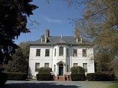
Arlington |
Upload image |
000000001992-05-21-0000May 21, 1992
(#92000588) |
Maryland Route 361
38°07′42″N 75°44′04″W / 38.128333°N 75.734444°W / 38.128333; -75.734444 (Arlington) |
Westover |
|
| 5 |
Beauchamp House |
Upload image |
000000001984-08-09-0000August 9, 1984
(#84003855) |
Old Westover-Marion Rd.
38°05′26″N 75°42′23″W / 38.090556°N 75.706389°W / 38.090556; -75.706389 (Beauchamp House) |
Westover |
|
| 6 |
Beckford |
Upload image |
000000001974-08-13-0000August 13, 1974
(#74000963) |
Beckford Ave.
38°12′02″N 75°41′56″W / 38.200556°N 75.698889°W / 38.200556; -75.698889 (Beckford) |
Princess Anne |
|
| 7 |
Beverly |
|
000000001973-03-30-0000March 30, 1973
(#73000937) |
South of Princess Anne on U.S. Route 13
38°09′27″N 75°41′22″W / 38.1575°N 75.689444°W / 38.1575; -75.689444 (Beverly) |
Princess Anne |
|
| 8 |
Brentwood Farm |
Upload image |
000000001986-09-04-0000September 4, 1986
(#86002174) |
Allen Rd.
38°15′58″N 75°41′22″W / 38.266111°N 75.689444°W / 38.266111; -75.689444 (Brentwood Farm) |
Westover |
|
| 9 |
Caldicott |
Upload image |
000000001983-12-22-0000December 22, 1983
(#83003796) |
Southwest of U.S. Route 13
38°03′13″N 75°39′02″W / 38.053611°N 75.650556°W / 38.053611; -75.650556 (Caldicott) |
Rehobeth |
|
| 10 |
Burton Cannon House |
Upload image |
000000001975-04-03-0000April 3, 1975
(#75000916) |
1 mile north of Cokesbury on Dublin Rd.
38°09′04″N 75°35′40″W / 38.151111°N 75.594444°W / 38.151111; -75.594444 (Burton Cannon House) |
Cokesbury |
|
| 11 |
Catalpa Farm |
Upload image |
000000001988-11-10-0000November 10, 1988
(#88002049) |
Old Princess Anne-Westover Rd.
38°11′09″N 75°40′46″W / 38.185833°N 75.679444°W / 38.185833; -75.679444 (Catalpa Farm) |
Princess Anne |
|
| 12 |
Cedar Hill |
Upload image |
000000001991-03-14-0000March 14, 1991
(#91000255) |
Eastern side of Sign Post Rd. at Back Creek
38°07′55″N 75°42′42″W / 38.131944°N 75.711667°W / 38.131944; -75.711667 (Cedar Hill) |
Westover |
|
| 13 |
CLARENCE CROCKETT |
Upload image |
000000001985-05-16-0000May 16, 1985
(#85001079) |
Lower Thorofare
38°07′41″N 75°56′54″W / 38.128056°N 75.948333°W / 38.128056; -75.948333 (CLARENCE CROCKETT) |
Wenona |
|
| 14 |
Coventry Parish Ruins |
Upload image |
000000001984-08-09-0000August 9, 1984
(#84001869) |
Off Maryland Route 667
38°02′18″N 75°39′59″W / 38.038333°N 75.666389°W / 38.038333; -75.666389 (Coventry Parish Ruins) |
Rehobeth |
|
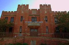
| 15 |
Crisfield Armory |
|
000000001985-09-25-0000September 25, 1985
(#85002669) |
Main St. Extended
38°00′29″N 75°50′34″W / 38.008056°N 75.842778°W / 38.008056; -75.842778 (Crisfield Armory) |
Crisfield |
|
| 16 |
Crisfield Historic District |
Upload image |
000000001990-07-09-0000July 9, 1990
(#90001018) |
Roughly bounded by Chesapeake Ave., Maryland Ave., 4th and Cove Sts., including area between Asbury Ave. and E. Main St.
37°58′53″N 75°50′57″W / 37.981389°N 75.849167°W / 37.981389; -75.849167 (Crisfield Historic District) |
Crisfield |
|
| 17 |
Cullen Homestead Historic District |
Upload image |
000000002009-11-18-0000November 18, 2009
(#09000932) |
4533, 27049, and 27067 Lawson Barnes Rd.
38°00′27″N 75°49′07″W / 38.007614°N 75.818581°W / 38.007614; -75.818581 (Cullen Homestead Historic District) |
Crisfield |
|
| 18 |
Deal Island Historic District |
Upload image |
000000002006-09-06-0000September 6, 2006
(#06000780) |
Deal Island Rd. from Upper Thorofare to Ballard Rd. and intersecting Sts.
38°09′38″N 75°56′49″W / 38.160556°N 75.946944°W / 38.160556; -75.946944 (Deal Island Historic District) |
Deal Island |
|
| 19 |
F.C. LEWIS, JR |
Upload image |
000000001985-05-16-0000May 16, 1985
(#85001080) |
Lower Thorofare
38°07′41″N 75°56′54″W / 38.128056°N 75.948333°W / 38.128056; -75.948333 (F.C. LEWIS, JR) |
Wenona |
|
| 20 |
FANNIE L. DAUGHERTY |
Upload image |
000000001985-05-16-0000May 16, 1985
(#85001081) |
Lower Thorofare
38°07′41″N 75°56′54″W / 38.128056°N 75.948333°W / 38.128056; -75.948333 (FANNIE L. DAUGHERTY) |
Wenona |
|
| 21 |
Glebe House |
Upload image |
000000002009-11-18-0000November 18, 2009
(#09000933) |
10950 Market Lane
38°10′51″N 75°41′25″W / 38.180911°N 75.690369°W / 38.180911; -75.690369 (Glebe House) |
Princess Anne |
|
| 22 |
Grace Episcopal Church |
Upload image |
000000001990-11-01-0000November 1, 1990
(#90001565) |
Mt. Vernon Rd. north of its junction with Ridge Rd.
38°14′36″N 75°46′09″W / 38.243333°N 75.769167°W / 38.243333; -75.769167 (Grace Episcopal Church) |
Mt. Vernon |
|
| 23 |
Harrington |
Upload image |
000000001975-09-11-0000September 11, 1975
(#75000918) |
Northwest of Princess Anne off Maryland Route 362
38°15′41″N 75°45′33″W / 38.261389°N 75.759167°W / 38.261389; -75.759167 (Harrington) |
Princess Anne |
|
| 24 |
Jeptha Hayman House |
Upload image |
000000001990-12-27-0000December 27, 1990
(#90001939) |
Westover-Marion Rd. south of its junction with Charles Barnes Rd.
38°04′08″N 75°42′26″W / 38.068889°N 75.707222°W / 38.068889; -75.707222 (Jeptha Hayman House) |
Kingston |
|
| 25 |
Hayward's Lott |
Upload image |
000000001976-05-13-0000May 13, 1976
(#76001009) |
1.75 miles northwest of Pocomoke City on Hayward Rd.
38°05′35″N 75°35′21″W / 38.093056°N 75.589167°W / 38.093056; -75.589167 (Hayward's Lott) |
Pocomoke City |
|
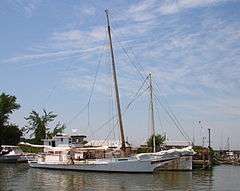
| 26 |
HOWARD (Skipjack) |
Upload image |
000000001985-05-16-0000May 16, 1985
(#85001082) |
Lower Thorofare
38°07′41″N 75°56′54″W / 38.128056°N 75.948333°W / 38.128056; -75.948333 (HOWARD (Skipjack)) |
Wenona |
|
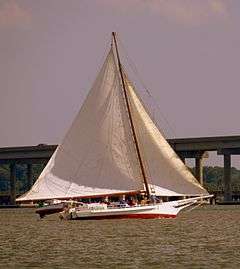
| 27 |
IDA MAY |
|
000000001985-05-16-0000May 16, 1985
(#85001077) |
Upper Thorofare
38°10′10″N 75°56′49″W / 38.169444°N 75.946944°W / 38.169444; -75.946944 (IDA MAY) |
Chance |
|
| 28 |
ISLAND BELLE |
Upload image |
000000001979-03-16-0000March 16, 1979
(#79001141) |
Ewell
37°59′47″N 76°01′44″W / 37.996389°N 76.028889°W / 37.996389; -76.028889 (ISLAND BELLE) |
Smith Island |
|
| 29 |
Kingston Hall |
|
000000001974-12-31-0000December 31, 1974
(#74000962) |
Western side of Maryland Route 667, 0.5 miles from Kingston
38°05′11″N 75°43′08″W / 38.086389°N 75.718889°W / 38.086389; -75.718889 (Kingston Hall) |
Kingston |
|
| 30 |
Lankford House |
Upload image |
000000001984-08-09-0000August 9, 1984
(#84001870) |
Maryland Route 667
38°03′04″N 75°42′21″W / 38.051111°N 75.705833°W / 38.051111; -75.705833 (Lankford House) |
Marion |
|
| 31 |
Liberty Hall |
Upload image |
000000001976-12-27-0000December 27, 1976
(#76001012) |
South of Westover off Maryland Route 361
38°05′35″N 75°43′48″W / 38.093056°N 75.73°W / 38.093056; -75.73 (Liberty Hall) |
Westover |
|
| 32 |
George Maddox Farm |
Upload image |
000000001985-09-17-0000September 17, 1985
(#85002410) |
River Rd.
38°05′59″N 75°45′05″W / 38.099722°N 75.751389°W / 38.099722; -75.751389 (George Maddox Farm) |
Manokin |
|
| 33 |
Maddux House |
Upload image |
000000002002-12-27-0000December 27, 2002
(#02001574) |
9084 Maddox Island Rd.
38°07′59″N 75°47′44″W / 38.133056°N 75.795556°W / 38.133056; -75.795556 (Maddux House) |
Upper Fairmount |
|
| 34 |
Make Peace |
|
000000001975-11-20-0000November 20, 1975
(#75000917) |
1.5 miles southeast of Crisfield on Johnson's Creek Rd.
37°58′25″N 75°49′13″W / 37.973611°N 75.820278°W / 37.973611; -75.820278 (Make Peace) |
Crisfield |
|
| 35 |
Manokin Historic District |
Upload image |
000000001976-06-29-0000June 29, 1976
(#76001010) |
Southwest of Princess Anne at the Manokin River
38°09′16″N 75°47′22″W / 38.154444°N 75.789444°W / 38.154444; -75.789444 (Manokin Historic District) |
Princess Anne |
|
| 36 |
Manokin Presbyterian Church |
|
000000001976-11-21-0000November 21, 1976
(#76001011) |
N. Somerset Ave.
38°12′27″N 75°41′43″W / 38.2075°N 75.695278°W / 38.2075; -75.695278 (Manokin Presbyterian Church) |
Princess Anne |
|
| 37 |
Mt. Zion Memorial Church |
Upload image |
000000002007-11-01-0000November 1, 2007
(#07001116) |
29071 Polks Rd.
38°15′37″N 75°44′38″W / 38.260278°N 75.743889°W / 38.260278; -75.743889 (Mt. Zion Memorial Church) |
Princess Anne |
|
| 38 |
Nelson Homestead |
Upload image |
000000001985-09-12-0000September 12, 1985
(#85002175) |
Cash Corner and Hopewell-Bedsworth Rds.
37°59′29″N 75°49′38″W / 37.991389°N 75.827222°W / 37.991389; -75.827222 (Nelson Homestead) |
Crisfield |
|
| 39 |
Panther's Den |
Upload image |
000000001984-03-22-0000March 22, 1984
(#84001872) |
Drawbridge Rd.
38°12′12″N 75°47′25″W / 38.203333°N 75.790278°W / 38.203333; -75.790278 (Panther's Den) |
Venton |
|
| 40 |
Pomfret Plantation |
Upload image |
000000001984-09-07-0000September 7, 1984
(#84001874) |
Maryland Route 667
38°02′31″N 75°48′06″W / 38.041944°N 75.801667°W / 38.041944; -75.801667 (Pomfret Plantation) |
Marion Station |
|
| 41 |
Princess Anne Historic District |
|
000000001980-10-14-0000October 14, 1980
(#80001834) |
Off Maryland Route 413
38°12′14″N 75°41′38″W / 38.203889°N 75.693889°W / 38.203889; -75.693889 (Princess Anne Historic District) |
Princess Anne |
|
| 42 |
Dr. William B. Pritchard House |
Upload image |
000000001996-08-08-0000August 8, 1996
(#96000879) |
29994 Polks Rd.
38°15′49″N 75°42′36″W / 38.263611°N 75.71°W / 38.263611; -75.71 (Dr. William B. Pritchard House) |
Princess Anne |
|
| 43 |
Puncheon Mill House |
Upload image |
000000001994-07-27-0000July 27, 1994
(#94000763) |
Puncheon Landing Rd.
38°04′35″N 75°36′26″W / 38.076389°N 75.607222°W / 38.076389; -75.607222 (Puncheon Mill House) |
Pocomoke City |
|
| 44 |
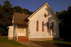
Quindocqua United Methodist Church |
|
000000001996-03-28-0000March 28, 1996
(#96000313) |
Junction of Quindocqua, Whittington, and L.Q. Powell Rds.
38°01′02″N 75°44′58″W / 38.017222°N 75.749444°W / 38.017222; -75.749444 (Quindocqua United Methodist Church) |
Marion Station |
|
| 45 |
Rehobeth Presbyterian Church |
Upload image |
000000001974-11-05-0000November 5, 1974
(#74000964) |
South of Rehobeth off Maryland Route 667
38°02′21″N 75°39′53″W / 38.039167°N 75.664722°W / 38.039167; -75.664722 (Rehobeth Presbyterian Church) |
Rehobeth |
|
| 46 |
Reward |
Upload image |
000000001974-08-13-0000August 13, 1974
(#74000965) |
Southeast of Shelltown on Williams Point Rd.
37°57′24″N 75°39′26″W / 37.956667°N 75.657222°W / 37.956667; -75.657222 (Reward) |
Shelltown |
|
| 47 |
Rock Creek Methodist Episcopal Church |
Upload image |
000000001990-11-02-0000November 2, 1990
(#90001718) |
Deal Island Rd. northeast of Scotts Cove
38°10′35″N 75°56′12″W / 38.176389°N 75.936667°W / 38.176389; -75.936667 (Rock Creek Methodist Episcopal Church) |
Chance |
|
| 48 |
Salisbury Plantation |
Upload image |
000000001975-06-20-0000June 20, 1975
(#75000919) |
Southwest of Westover off Maryland Route 361
38°05′18″N 75°44′13″W / 38.088333°N 75.736944°W / 38.088333; -75.736944 (Salisbury Plantation) |
Westover |
|
| 49 |
Schoolridge Farm |
Upload image |
000000001984-09-07-0000September 7, 1984
(#84001876) |
Maryland Route 361
38°05′53″N 75°48′19″W / 38.098056°N 75.805278°W / 38.098056; -75.805278 (Schoolridge Farm) |
Upper Fairmount |
|
| 50 |
SEA GULL |
Upload image |
000000001985-05-16-0000May 16, 1985
(#85001078) |
Lower thorofare
38°07′41″N 75°56′54″W / 38.128056°N 75.948333°W / 38.128056; -75.948333 (SEA GULL) |
Deal Island |
|
| 51 |
William S. Smith House |
Upload image |
000000001991-07-09-0000July 9, 1991
(#91000891) |
Southern side of Oriole Rd., east of its junction with Crab Island Rd.
38°10′22″N 75°48′56″W / 38.172778°N 75.815556°W / 38.172778; -75.815556 (William S. Smith House) |
Oriole |
|
| 52 |
Somerset Academy Archaeological Site |
|
000000001986-09-11-0000September 11, 1986
(#86002356) |
Address Restricted
|
Princess Anne |
|
| 53 |
St. John's Methodist Episcopal Church and Joshua Thomas Chapel |
Upload image |
000000001990-11-01-0000November 1, 1990
(#90001550) |
Deal Island Rd. north of its junction with Tangier Rd.
38°09′19″N 75°56′50″W / 38.155278°N 75.947222°W / 38.155278; -75.947222 (St. John's Methodist Episcopal Church and Joshua Thomas Chapel) |
Deal Island |
|
| 54 |
St. Mark's Episcopal Church |
Upload image |
000000001990-10-25-0000October 25, 1990
(#90001569) |
Junction of Westover-Marion and Charles Barnes Rds.
38°04′21″N 75°42′35″W / 38.0725°N 75.709722°W / 38.0725; -75.709722 (St. Mark's Episcopal Church) |
Kingston |
|
| 55 |
St. Paul's Methodist Episcopal Church |
Upload image |
000000001996-04-12-0000April 12, 1996
(#96000403) |
Junction of Maryland Route 413 and Sign Rd.
38°07′23″N 75°42′26″W / 38.123056°N 75.707222°W / 38.123056; -75.707222 (St. Paul's Methodist Episcopal Church) |
Westover |
|
| 56 |
St. Paul's Protestant Episcopal Church |
Upload image |
000000001990-08-03-0000August 3, 1990
(#90001153) |
Near the junction of Farm Market Rd. and St. Pauls Church Rd.
38°00′56″N 75°46′14″W / 38.015556°N 75.770556°W / 38.015556; -75.770556 (St. Paul's Protestant Episcopal Church) |
Tulls Corner |
|
| 57 |
St. Peter's Methodist Episcopal Church |
Upload image |
000000001990-11-02-0000November 2, 1990
(#90001721) |
Junction of Old Crisfield-Marion Rd. and Heart's Ease Rd.
38°01′01″N 75°49′13″W / 38.016944°N 75.820278°W / 38.016944; -75.820278 (St. Peter's Methodist Episcopal Church) |
Hopewell |
|
| 58 |
Sudler's Conclusion |
|
000000001973-08-28-0000August 28, 1973
(#73000936) |
Northwest of Manokin off Maryland Route 361
38°07′16″N 75°46′37″W / 38.121111°N 75.776944°W / 38.121111; -75.776944 (Sudler's Conclusion) |
Manokin |
|
| 59 |
SUSAN MAY |
Upload image |
000000001985-05-16-0000May 16, 1985
(#85001083) |
Lower Thorofare
38°07′41″N 75°56′54″W / 38.128056°N 75.948333°W / 38.128056; -75.948333 (SUSAN MAY) |
Wenona |
|
| 60 |
Capt. Leonard Tawes House |
Upload image |
000000001990-04-05-0000April 5, 1990
(#90000598) |
Somerset Ave.
37°58′32″N 75°50′43″W / 37.975556°N 75.845278°W / 37.975556; -75.845278 (Capt. Leonard Tawes House) |
Crisfield |
|
| 61 |
Teackle Mansion |
|
000000001971-10-26-0000October 26, 1971
(#71000378) |
Mansion St.
38°12′12″N 75°42′08″W / 38.203333°N 75.702222°W / 38.203333; -75.702222 (Teackle Mansion) |
Princess Anne |
|
| 62 |
THOMAS W. CLYDE |
|
000000001985-05-16-0000May 16, 1985
(#85001084) |
Lower Thorofare
38°07′41″N 75°56′54″W / 38.128056°N 75.948333°W / 38.128056; -75.948333 (THOMAS W. CLYDE) |
Wenona |
|
| 63 |
Tudor Hall |
Upload image |
000000001974-12-19-0000December 19, 1974
(#74000966) |
Southeast of Upper Fairmount off Maryland Route 361
38°05′52″N 75°46′31″W / 38.097778°N 75.775278°W / 38.097778; -75.775278 (Tudor Hall) |
Upper Fairmount |
|
| 64 |
William T. Tull House |
Upload image |
000000001996-03-26-0000March 26, 1996
(#96000302) |
Along the western side of Maryland Route 413
38°07′32″N 75°42′22″W / 38.125556°N 75.706111°W / 38.125556; -75.706111 (William T. Tull House) |
Westover |
|
| 65 |
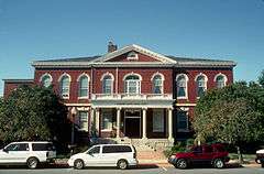
University of Maryland Eastern Shore |
Upload image |
000000002005-09-16-0000September 16, 2005
(#05001021) |
1 Backbone Rd.
38°12′36″N 75°41′08″W / 38.21°N 75.685556°W / 38.21; -75.685556 (University of Maryland Eastern Shore) |
Princess Anne |
|
| 66 |
Upper Fairmount Historic District |
Upload image |
000000001993-09-13-0000September 13, 1993
(#93000900) |
Both sides of Maryland Route 361
38°06′25″N 75°48′01″W / 38.106944°N 75.800278°W / 38.106944; -75.800278 (Upper Fairmount Historic District) |
Upper Fairmount |
|
| 67 |
Waddy House |
Upload image |
000000001988-11-03-0000November 3, 1988
(#88002221) |
Perryhawkin Rd.
38°11′37″N 75°38′54″W / 38.193611°N 75.648333°W / 38.193611; -75.648333 (Waddy House) |
Princess Anne |
|
| 68 |
Ward Brothers' House and Shop |
|
000000001997-11-21-0000November 21, 1997
(#94000790) |
3199 Sackertown Rd.
37°58′13″N 75°50′42″W / 37.970278°N 75.845°W / 37.970278; -75.845 (Ward Brothers' House and Shop) |
Crisfield |
|
| 69 |
Waterloo |
Upload image |
000000001986-02-13-0000February 13, 1986
(#86000257) |
Mt. Vernon Rd.
38°13′35″N 75°45′09″W / 38.226389°N 75.7525°W / 38.226389; -75.7525 (Waterloo) |
Princess Anne |
|
| 70 |
Waters' River |
Upload image |
000000001984-08-09-0000August 9, 1984
(#84001882) |
Hood Rd.
38°05′54″N 75°45′50″W / 38.098333°N 75.763889°W / 38.098333; -75.763889 (Waters' River) |
Manokin |
|
| 71 |
Watkins Point Farm |
Upload image |
000000002002-12-27-0000December 27, 2002
(#02001586) |
27737 Phoenix Church Rd.
37°58′51″N 75°47′28″W / 37.980833°N 75.791111°W / 37.980833; -75.791111 (Watkins Point Farm) |
Marion Station |
|
| 72 |
White Hall |
Upload image |
000000001984-06-07-0000June 7, 1984
(#84003868) |
Cooley Rd.
38°15′59″N 75°43′23″W / 38.266389°N 75.723056°W / 38.266389; -75.723056 (White Hall) |
Princess Anne |
|
| 73 |
Williams' Conquest |
Upload image |
000000001984-05-03-0000May 3, 1984
(#84001886) |
Charles Cannon Rd.
38°04′23″N 75°45′43″W / 38.073056°N 75.761944°W / 38.073056; -75.761944 (Williams' Conquest) |
Marion Station |
|
.jpg)
.jpg)

_2.jpg)
.jpg)

