Kentucky Route 15
| ||||
|---|---|---|---|---|
| Route information | ||||
| Maintained by KYTC | ||||
| Length: | 131.418 mi[1] (211.497 km) | |||
| Major junctions | ||||
| South end: |
| |||
|
| ||||
| North end: |
| |||
| Location | ||||
| Counties: | Letcher, Knott, Perry, Breathitt, Wolfe, Powell, Clark | |||
| Highway system | ||||
| ||||

Kentucky Route 15 begins at a junction of US 119/Corridor F & Business KY 15 in Whitesburg, and terminates in Winchester at US 60. It is a major route, connecting the coalfields of the Cumberland Plateau with Lexington and other cities in the Bluegrass region. The segment from Whitesburg to KY 15 at Campton, which in turn connects to the Bert T. Combs Mountain Parkway near the town, is also the primary part of Corridor I of the Appalachian Development Highway System.
Future
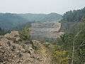
Currently, KY 15 is being relocated onto a new four-lane divided alignment in phases. Construction on section 17 of the relocation project is from KY 205 at Vancleve to Fivemile; construction began on January 6, 2005 at a cost of $36.4 million and is 100% complete.[2] Work is also progressing on section 16 from Fivemile to Wolverine; construction began on November 2, 2006 with a projected cost of $4.7 million and is approximately 95% complete. There are additional plans to reconstruct the segment from Jackson south to Hazard on new alignment beginning in 2008.
The current construction is progressing from Vancleve to Jackson. Local reports suggest that the roadway will be opening for traffic flow by the summer of 2013. Construction of the section between Jackson and Haddix, KY has not started. The current budget crisis and lowered revenues for state and federal construction projects may delay groundbreaking on that section for years. (Updated June 2013)
-

Working on a cut near Vancleve.
-
Looking north across Frozen Creek and KY 1812.
-
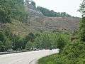
Looking south on KY 15 near the northern end of construction on section 17 at KY 205.
Major intersections
| County | Location | mi | km | Destinations | Notes |
|---|---|---|---|---|---|
| Letcher | Whitesburg | ||||
| Letcher County Veterans Memorial Museum (KY 15C north) | |||||
| south end of KY 931 overlap | |||||
| north end of KY 931 overlap | |||||
| | |||||
| | |||||
| Van | south end of KY 160 overlap | ||||
| | |||||
| Isom | south end of KY 7 overlap | ||||
| | north end of KY 7 overlap | ||||
| Knott | | north end of KY 160 overlap | |||
| | |||||
| Sassafras | |||||
| Perry | Vicco | ||||
| Jeff | interchange | ||||
| Glomawr | |||||
| | |||||
| Hazard | |||||
| interchange | |||||
| interchange; south end of KY 80 overlap | |||||
| interchange; north end of KY 80 overlap | |||||
| Bonnyman | |||||
| | |||||
| | |||||
| Breathitt | Ned | ||||
| | |||||
| Lost Creek | |||||
| Haddix | |||||
| | |||||
| | south end of KY 30 overlap | ||||
| Jackson | south end of KY 1812 overlap | ||||
| north end of KY 1812 overlap | |||||
| north end of KY 30 overlap | |||||
| | south end of KY 205 overlap | ||||
| | north end of KY 205 overlap | ||||
| | south end of KY 1812 overlap | ||||
| Vancleve | interchange; north end of KY 1812 overlap | ||||
| Wolfe | Bethany | south end of KY 1261 overlap | |||
| north end of KY 1261 overlap | |||||
| | |||||
| | |||||
| Campton | |||||
| | |||||
| | |||||
| | Mountain Pkwy. exit 40 | ||||
| | south end of KY 715 overlap | ||||
| Pine Ridge | north end of KY 715 overlap | ||||
| Powell | Slade | south end of KY 11 overlap | |||
| Nada | |||||
| | |||||
| Bowen | |||||
| | |||||
| Rosslyn | |||||
| Stanton | |||||
| Clay City | |||||
| Clay City (Waltersville) | north end of KY 11 overlap | ||||
| Clay City (Powell Valley) | |||||
| Mountain Pkwy. exit 16 | |||||
| Virden | |||||
| Clark | | south end of KY 974 overlap | |||
| Goffs Corner | north end of KY 974 overlap | ||||
| Pilot View | |||||
| | |||||
| | |||||
| Winchester | |||||
| 1.000 mi = 1.609 km; 1.000 km = 0.621 mi | |||||
Bannered routes
Kentucky Route 15X
| |
|---|---|
| Location: | Whitesburg, Letcher County |
| Length: | 2.838 mi[1] (4.567 km) |
Kentucky Route 15 Business in Whitesburg, in Letcher County, signed as KY 15X, is the business route of KY 15 in Whitesburg. It begins at KY 15's southern terminus and ends at KY 15 north of town. The route is 2.838 miles (4.567 km) long.
Kentucky Route 15 Connector
| |
|---|---|
| Location: | Whitesburg, Letcher County |
| Length: | 0.24 mi[1] (0.386 km) |
Kentucky Route 15 Connector (KY 15C) provides access from KY 15 to KY KY 15X and the Letcher County Veterans Memorial Museum in Whitesburg. It is 0.24 miles (0.39 km) long.
Kentucky Route 15 Business (Hazard)
| |
|---|---|
| Location: | Hazard, Perry County |
| Length: | 2.306 mi[1] (3.711 km) |
Kentucky Route 15 Business (KY 15 BUS) is a business route of KY 15 in Hazard, Perry County. It is the original alignment of KY 15 through the city. It is 2.306 miles (3.711 km) long.
References
- 1 2 3 4 "Kentucky Transportation Cabinet - Division of Planning - Highway Information System Official Milepoint Route Log Extract". Archived from the original on April 30, 2007. Retrieved 2007-06-11.
- ↑ KY-15 Corridor. Kentucky Transportation Cabinet. Archived from the original on March 3, 2007. Retrieved 2007-05-17.