Giresun
| Giresun | ||
|---|---|---|
| Municipality | ||
|
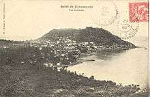
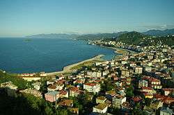
General view of eastern part of Giresun city | ||
| ||
 Giresun | ||
| Coordinates: 40°54′55″N 38°23′22″E / 40.91528°N 38.38944°ECoordinates: 40°54′55″N 38°23′22″E / 40.91528°N 38.38944°E | ||
| Country | Turkey | |
| Province | Giresun | |
| Government | ||
| • Mayor | Kerim Aksu (CHP) | |
| Area[1] | ||
| • District | 295.71 km2 (114.17 sq mi) | |
| Population (2012)[2] | ||
| • Urban | 100,712 | |
| • District | 123,129 | |
| • District density | 420/km2 (1,100/sq mi) | |
| Climate | Cfa | |
| Website |
www | |
Giresun (pronounced [ɡiɾeˈsun]) is the provincial capital of Giresun Province in the Black Sea Region of northeastern Turkey, about 175 km (109 mi) west of the city of Trabzon.
Etymology
Giresun was known to the ancient Greeks as Choerades or more prominently as Kerasous or Cerasus (Ancient Greek: Κερασοῦς), the origin of the modern name.
Pre-Greek and Greek linguist Robert S. P. Beekes has stated that the name Kerasous corresponds to κερασός (kerasós) "cherry" + -ουντ (a place marker).[3] Thus, he notes that the Greek root of the word "cherry", κερασός (kerasós), predates the name of the city,[3] Beekes holds that the ultimate origin of the word cherry (and thus the name of the city) is from a Pre-Greek substrate, likely of Anatolian origin, given the intervocalic σ in Κερασοῦς and the apparent cognates of it found in other languages the region.[3]
However, Black Sea Region researcher Özhan Öztürk has said that Kerasous instead corresponds to κέρας (keras) "horn" + -ουντ (a place marker), for the prominent horn-shaped peninsula that the city is situated on (compare with the Greek name for the horn-shaped Golden Horn waterway in Istanbul, Κέρας (Keras) "Horn").[4] According to Öztürk, the toponym later mutated into Kerasunt (sometimes written Kérasounde or Kerassunde), and the word "cherry" (as well as its cognates found in other local languages) was derived from the name of the city itself, rather than the other way around as Beekes claims.[4]
Pharnaces I of Pontus renamed the city Pharnacia after himself after he captured the city in 183 BCE, and it was called by that name as late as the 2nd century CE. According to A. H. M. Jones, the city officially reverted to its original name, Kerasous, in 64 CE.[5] Whatever the etymology, the Greek name Kerasous was Turkified into Giresun after Turks gained permanent control of the region in the late 15th century.
The English word cherry, French cerise, Spanish cereza, Persian گیلاس (gilas) and Turkish kiraz, among countless others, all come from Ancient Greek κερασός "cherry tree", which has been identified with Kerasous, although whether the word κερασός pre-dates the city's name or not is up for debate, as noted above. According to Pliny, the cherry was first exported from Cerasus to Europe in Roman times by Lucullus.[6]
Geography
The surrounding region has a rich agriculture, growing most of Turkey's hazelnuts as well as walnuts, cherries, leather and timber, and the port of Giresun has long handled these products. The harbour was enlarged in the 1960s and the town is still a port and commercial centre for the surrounding districts, but Giresun is not large, basically one avenue of shops leading away from the port.
Like everywhere else on the Black Sea coast it rains (and often snows in winter) and is very humid throughout the year, with a lack of extreme temperatures both in summer and winter. As a result Giresun and the surrounding countryside is covered by luxuriant flora. As soon as you get beyond the city buildings you get into the hazelnut growing area and the high pastures (yayla) further in the mountains are gorgeous.
Climate
Giresun has an humid subtropical climate (Köppen climate classification: Cfa), like most of the eastern Black Sea coast of Turkey, with warm and humid summers and cool and damp winters. Giresun has a high and evenly distributed precipitation throughout the year. Precipitation is heaviest in autumn and spring.
Snowfall is quite common between the months of December and March, snowing for a week or two, and it can be heavy once it snows.
The water temperature, like in the rest of the Black Sea coast of Turkey, is always cool and fluctuates between 8° and 20 °C throughout the year.
| Climate data for Giresun | |||||||||||||
|---|---|---|---|---|---|---|---|---|---|---|---|---|---|
| Month | Jan | Feb | Mar | Apr | May | Jun | Jul | Aug | Sep | Oct | Nov | Dec | Year |
| Record high °C (°F) | 24.9 (76.8) |
29.5 (85.1) |
34.9 (94.8) |
36.0 (96.8) |
35.4 (95.7) |
36.2 (97.2) |
35.3 (95.5) |
35.2 (95.4) |
32.8 (91) |
37.3 (99.1) |
32.8 (91) |
28.0 (82.4) |
37.3 (99.1) |
| Average high °C (°F) | 10.6 (51.1) |
10.7 (51.3) |
11.7 (53.1) |
15.1 (59.2) |
18.8 (65.8) |
23.4 (74.1) |
26.1 (79) |
26.5 (79.7) |
23.6 (74.5) |
19.7 (67.5) |
16.1 (61) |
12.9 (55.2) |
17.93 (64.29) |
| Daily mean °C (°F) | 7.3 (45.1) |
7.2 (45) |
8.1 (46.6) |
11.4 (52.5) |
15.5 (59.9) |
20.0 (68) |
22.7 (72.9) |
23.0 (73.4) |
20.0 (68) |
16.2 (61.2) |
12.5 (54.5) |
9.5 (49.1) |
14.45 (58.02) |
| Average low °C (°F) | 4.7 (40.5) |
4.4 (39.9) |
5.3 (41.5) |
8.6 (47.5) |
12.7 (54.9) |
16.9 (62.4) |
19.8 (67.6) |
20.1 (68.2) |
17.2 (63) |
13.6 (56.5) |
9.9 (49.8) |
6.8 (44.2) |
11.67 (53) |
| Record low °C (°F) | −6.2 (20.8) |
−9.8 (14.4) |
−4.0 (24.8) |
−1.4 (29.5) |
4.0 (39.2) |
6.8 (44.2) |
12.1 (53.8) |
12.1 (53.8) |
4.8 (40.6) |
4.3 (39.7) |
−4.7 (23.5) |
−2.4 (27.7) |
−9.8 (14.4) |
| Average precipitation mm (inches) | 122.1 (4.807) |
97.7 (3.846) |
91.3 (3.594) |
77.3 (3.043) |
69.9 (2.752) |
78.0 (3.071) |
75.9 (2.988) |
88.4 (3.48) |
126.0 (4.961) |
167.0 (6.575) |
148.0 (5.827) |
124.4 (4.898) |
1,266 (49.842) |
| Average rainy days | 14.8 | 14.2 | 16.2 | 15.5 | 14.6 | 11.9 | 10.6 | 10.8 | 12.8 | 14.4 | 13.6 | 14.4 | 163.8 |
| Mean monthly sunshine hours | 74.4 | 86.8 | 86.8 | 114 | 164.3 | 192 | 186 | 139.5 | 114 | 105.4 | 96 | 58.9 | 1,418.1 |
| Mean daily sunshine hours | 1.5 | 2.4 | 2.5 | 3.6 | 5.1 | 6.5 | 5.5 | 5.0 | 4.1 | 3.0 | 3.2 | 1.5 | 3.66 |
| Source: Turkish State Meteorological Service [7] | |||||||||||||
History

Giresun's history goes back to the late 6th century BC, when it was founded by Greek colonists from Sinope, 110 km east of the homonymous city founded by Pharnaces I of Pontus, using citizens transferred from Kotyora (modern Ordu), circa 180 BCE.[8] The name of the city is first cited in the book Anabasis by Xenophon as Kerasus. Historic records reveal that the city was dominated by the Miletians, Persians, Romans, Byzantines and Empire of Trebizond. The older parts of the city lie on a peninsula crowned by a ruined Byzantine fortress, sheltering the small natural harbour. Nearby is Giresun Island, in ancient times called Aretias, the only major Black Sea island in Turkish territory. According to legend, the island was sacred to the Amazons, who had dedicated a temple to the war god Ares here. Even today, fertility rites are performed there every May, usually involving the famed boulder named the Hamza Stone on the east side of the island, now shrouded as a popular practice but in reality a 4,000-year-old celebration.
Cerasus in late antiquity became a Christian bishopric, and the names of several of its bishops are preserved in the acts of church councils: Gregorius at the Council of Ephesus in 431, Gratianus at the Council of Chalcedon in 451, Theophylactus at the Third Council of Constantinople in 680, Narses at the Trullan Council in 692, Ioannes at the Second Council of Nicaea in 787, and Simeon at the Photian Council of Constantinople in 879. An episcopal seal records a Leo of the 9th century, and a Michael was transferred from here to the see of Ancyra at the time of Michael Caerularius.[9][10][11] It was the seat of a Greek Orthodox metropolitan until 1703, when the city was placed under the metropolitan of Trebizond.[12] Accordingly, it is today listed by the Catholic Church as a titular see.[13] The Ecumenical Patriarchate of Constantinople also considers Cerasus (Kerasous), together with Chaldia and Cheriana, as a titular metropolitanate in Turkey.
During the medieval period, Kerasunt was part of the Byzantine Empire and later the second city of the Empire of Trebizond ruled by the Komnenian dynasty. Alexios II Komnenos, Emperor of Trebizond, defeated the Turkmen "Koustoganes" at Kerasunt in September 1302; to secure his victory, Alexios II built a fortress which overlooks the sea.[14] From 1244 onwards the Seljuk Turks moved into the area, pursued at times by the Mongol hordes until in 1461, subsequent to the fall of Constantinople, the whole of this coast was brought within the Ottoman Empire by Sultan Mehmet II. It was briefly occupied by Emirate of Hacıemiroğlu (Emirate of Chalybia) between 1398-1400. Local traditions claim that Kerasunt held out for many months after the fall of Trebizon in 1461, then surrendered on terms that the Christian inhabitants could remain and retain their arms, but were required to maintain a boat for the use of the Turks on a nearby river.[15]
4.2 km east-northeast of Kerasus is a fortified island called Ares (Αρητιας νήσος or Αρεώνησος). According to the poetic account of Apollonius of Rhodes, it was here that the Argonauts encountered both the Amazons and a flock of vicious birds. The Greeks of the island held out against the Ottomans for 7 years after the fall of Trebizond (modern Trabzon) in 1461.
Economy
Historically, Giresun was known for producing hazelnut. As of 1920, hazelnuts covered 460 square miles of the area. [16] Manganese mines were also in the area, producing 470 tons as of 1901.[17]
Places of interest
- The well preserved Giresun Castle in the city centre.
- Giresun Island
- Hacı Hüseyin Mosque, Kale Mosque, Seyyid-i Vakkas tomb, Mausoleum of Topal Osman
- Old Ottoman houses of Zeytinlik district
- Highlands (Kümbet, Bektaş, Kulakkaya, Çakrak, Tohumluk, Kurtbeli, Kazıkbeli, Ayıbeli, Beytarla, Buları, Kırkharman)
International relations
Twin towns and sister cities
Giresun is twinned with:
-
 Sagae, Yamagata Prefecture, Japan [18] (since June 25, 1988)
 -
 Shaki, Azerbaijan (since March 12, 2001)
References
- ↑ "Area of regions (including lakes), km²". Regional Statistics Database. Turkish Statistical Institute. 2002. Retrieved 2013-03-05.
- ↑ "Population of province/district centers and towns/villages by districts - 2012". Address Based Population Registration System (ABPRS) Database. Turkish Statistical Institute. Retrieved 2013-02-27.
- 1 2 3 Robert S. P. Beekes (2010). Etymological Dictionary of Greek. Brill. ISBN 978-90-04-17418-4.
As the improved cherry came from the Pontos area (cf. Κερασοῦς "rich in cherries", town on the Pontos), the name is probably Anatolian as well. Given its intervocalic σ, the form must be Anatolian or Pre-Greek. For the suffix, cf. ▶-θíασος, ▶-κάρπασος, which too are of foreign origin. Assyr. karšu has also been adduced. Cf. on ▶κράνον 'cornelian cherry'. Gr. κέρασος, -íα, κεράσιον were borrowed into many languages: Asiatic names of the cherry-tree and the cherry, like Arm. ker̄as, Kurd. ghilas, and in the West, Lat. cerasus, -ium, VLat. ★cerasia, ★ceresia, -ea; from Latin came the Romance and Germanic forms like MoFr. cerise, OHG chirsa > Kirsche. Lit.: Olck in PW 11: 509f. and Hester Lingua 13 (1965): 356.
- 1 2 Özhan Öztürk (2005). Karadeniz: Ansiklopedik Sözlük [Black Sea: Encyclopedic Dictionary]. Istanbul: Heyamola Publishing. ISBN 975-6121-00-9.
- ↑ Arrian: Periplus Ponti Euxini, edited and translated by Aidan Liddle (London: Bristol Classical Press, 2003), p. 117
- ↑ Pliny the Elder. "Olives, olive-oil and fruit-trees". Natural History 15.30.
Before the victory of Lucius Lucullus in the war against Mithridates, that is down to 74 BCE, there were no cherry-trees in Italy. Lucullus first imported them from Pontus...
- ↑ "Giresun". Turkish State Meteorological Service. Retrieved 1 September 2016.
- ↑ The Princeton Encyclopedia of Classical Sites, PHARNAKEIA KERASOUS (Giresun) Pontus, Turkey
- ↑ Michel Lequien, Oriens christianus in quatuor Patriarchatus digestus, Paris 1740, Vol. I, coll. 513-516
- ↑ Raymond Janin, v. Cérasonte, in Dictionnaire d'Histoire et de Géographie ecclésiastiques, vol. XII, Paris 1953, coll. 154-155
- ↑ Pius Bonifacius Gams, Series episcoporum Ecclesiae Catholicae, Leipzig 1931, p. 442
- ↑ Speros Vryonis Jr., The Decline of medieval Hellenism in Asia Minor: and the process of Islamization from the eleventh through the fifteenth century, (Berkeley: University of California, 1971), p. 449 n. 13
- ↑ Annuario Pontificio 2013 (Libreria Editrice Vaticana 2013 ISBN 978-88-209-9070-1), p. 866
- ↑ William Miller, Trebizond: The last Greek Empire of the Byzantine Era: 1204-1461, 1926 (Chicago: Argonaut, 1969), p. 33
- ↑ Miller, Trebizond, p. 107
- ↑ Prothero, W.G. (1920). Armenia and Kurdistan. London: H.M. Stationery Office. p. 61.
- ↑ Prothero, W.G. (1920). Armenia and Kurdistan. London: H.M. Stationery Office. p. 73.
- ↑ "International Exchange". List of Affiliation Partners within Prefectures. Council of Local Authorities for International Relations (CLAIR). Retrieved 21 November 2015.
- The Byzantine Monuments and Topgraphy of the Pontos by A. Bryer and D. Winfield
- The Encyclopaedia of Pontian Hellenism.
External links
| Wikimedia Commons has media related to Giresun. |
- Official website
- Giresun culture and travel info
- Giresun.com.tr (in Turkish)
- Giresun culture and travel info (in Turkish)
- Çanakçı photos
- Kerasus (Giresun)

