Görele
| Görele | ||
|---|---|---|
| Town | ||
| ||
 Görele | ||
| Coordinates: 41°02′N 39°02′E / 41.033°N 39.033°ECoordinates: 41°02′N 39°02′E / 41.033°N 39.033°E | ||
| Country |
| |
| Region | Black Sea | |
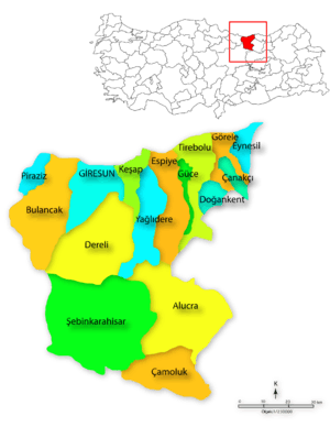
| Province | Giresun | |
| Government | ||
| • Mayor | Tolga Erener (AKP) | |
| Area[1] | ||
| • District | 178.65 km2 (68.98 sq mi) | |
| Elevation | 158 m (518 ft) | |
| Population (2012)[2] | ||
| • Urban | 15,839 | |
| • District | 30,276 | |
| • District density | 170/km2 (440/sq mi) | |
| Time zone | EET (UTC+2) | |
| • Summer (DST) | EEST (UTC+3) | |
| Postal code | 28800 | |
| Area code(s) | (+90) 454 | |
| Licence plate | 28 | |
| Climate | Cfa | |
| Website | http://www.gorele.bel.tr | |

Görele is a town and a district of Giresun Province on the Black Sea coast of eastern Turkey. The population was 16,033 in 2010.
Geography
The district is mainly mountainous and watered by streams and rivers running into the Black Sea, the highest peaks are Mount Sis and Haç (Haş). Up to 600m the hillsides are covered with hazelnuts, along with alder, poplars and other deciduous trees. The agriculture of the district is mainly hazelnuts along with some tea planting, beekeeping, and gardening for domestic consumption, while the higher elevations are forest and pasture.
Recently trout farming has begun in the mountain waterways and more importantly the attractive high pasture lands have begun to attract visitors on trekking holidays. Traditionally in this part of the world people would move their sheep and cattle to the high pastures (yayla) for summer grazing and today this has become something of an event with summer folklore festivals in places like Sis Dağı attracting visitors from all over Turkey, who come to hear the Kemençe and watch people dance the Horon. The sale of local costumes and craftwork such as wooden toys and woven goods bring extra income to the district.
The climate is typical of the Black Sea region; it rains in every season and in the high mountains it snows in winter. The mountain hinterland is hard to access, with many dirt roads and the villages are continuously shrinking as the villagers migrate to Turkey's larger cities in search of work.
Görele itself is a large town of 27,000 people on the Black Sea coast. The Black Sea coast highway from Giresun to Trabzon runs through here and Görele is about halfway between the two cities, 70 km from each. There is no real port at Görele so goods and people all come though this coast road, but there is a small fishing fleet. The main industry is hazelnut processing, and in August the whole area is busy with people harvesting hazelnuts and bringing them into town.
Görele has its own kemençe style and tradition. Famous Görelean kemençe players include Halil Ağa and Picoğlu Osman.
History
There was a Genoese trading post here and the ruins of their castle is 20 km east of the town of Görele today. Chepni Turks arrived Görele from Khorasan in the early years of the 13/14th century.
As the castle of Kordyle, this was one of the last Christian outposts to fall to Sultan Mehmet II after he conquered the Empire of Trebizond in 1461. According to Pontic ballads, it was defended against the Sultan's soldier by a peasant girl until she took her life by throwing herself from a window. According to William Miller, the window could still be seen up to the Crimean War.[3]
From 1878 to 1922, it was a part of Ottoman Trebizond Vilayet. During republic era, it became a part of newly founded Giresun province.
Görele, like the rest of this coast was occupied by Russian troops for two years during the First World War.
Prominent natives/residents
- Tuzcuoğlu Mehmet Ali, kemenche player
- Picoğlu Osman (1901-1946) famous kemençe player
- Hasan Ali Yücel poet and politician, former minister of education, and his son the poet Can Yücel
- Hamit Görele, artist and thinker
- Bedri Rahmi Eyüboğlu artist and poet
- Fatih Kırtorun, poet
- Kemal Gürses, conductor and composer[4]
See also
References
- ↑ "Area of regions (including lakes), km²". Regional Statistics Database. Turkish Statistical Institute. 2002. Retrieved 2013-03-05.
- ↑ "Population of province/district centers and towns/villages by districts - 2012". Address Based Population Registration System (ABPRS) Database. Turkish Statistical Institute. Retrieved 2013-02-27.
- ↑ Miller, Trebizond: The last Greek Empire of the Byzantine Era: 1204-1461, 1926 (Chicago: Argonaut, 1969), p. 107
- ↑ Kemal Gürses profile, gorele.gen.tr; accessed 20 May 2012).
External links
- (Turkish) Gorele News Official Page
- (Turkish) GoreleGenclik Official Page
- (Turkish) Gorele News Official Page
- (Turkish) Radyo Gorele Official Page
- (Turkish) Gorelespor Official Page
- (Turkish) Gorele School Official Page
- (Turkish) Gorele Official Page
- (Turkish) Gorele Official Page
- (Turkish) Gorele Ekspres Official Page